
by Elizabeth Goldbaum Thursday, May 19, 2016
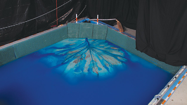
Researchers used an experimental basin filled with water and sand-, silt- and clay-sized sediments to mimic natural deltas and study the formation and preservation of stratigraphic records. Credit: Kyle Straub.
Earth’s stratigraphic record offers a patchwork diary of how different parts of the planet have formed and changed over time. Some of the most extensive pieces of the stratigraphic record are found in deltas, making them ideal places to look for long-term chronicles of Earth’s history, as well as clues to future changes to our coastal landscapes.
The stratigraphy of deltas, which form where rivers empty into the ocean, is primarily controlled by fluctuations in sea level. When sea level rises and shorelines move inland, for example, the layers of sediment deposited in a delta may change from sands and plant roots washed down rivers to mud and shells more characteristic of deeper marine environments. But internal processes in deltas, such as the shifting paths of different stream channels, muddle records of sea-level fluctuations caused by external events like glaciations, complicating efforts to interpret those records. In a new study published in Geology, researchers using physical models to imitate natural deltaic processes have shed new light on how and when scientists can confidently use deltaic stratigraphic records to glean insights into Earth history.
The team constructed model river deltas out of sand-, silt- and clay-sized sediment grains in an experimental basin in a laboratory. The setup allowed them to control the amount of water that flowed into and out of the delta, the amount of sediment that settled in the delta, and the level of the model ocean surface in the basin. During experiments in which sea level was raised at a constant rate, for instance, they observed “incredibly vibrant … dynamics that were happening with the delta,” says Kyle Straub, a sedimentologist at Tulane University and a co-author of the study. Stream channels jumped around, moving to new locations and adding their own story to changes in the model stratigraphic record brought by the rising and lowering sea level.
The goal of the work, Straub says, is to distinguish records of sea-level variations caused by larger environmental changes outside the delta from changes caused by a delta’s internal activity.
Sea levels have naturally fluctuated in the past — rising and falling by millimeters over periods of days, up to hundreds of meters over hundreds of millions of years. Short-period sea-level fluctuations are primarily driven by shifting atmospheric conditions, such as storms over deltas; longer-period fluctuations can be caused by widespread glaciation or the breakup or assembly of supercontinents. “Earth has done countless natural experiments for us,” says Chris Paola, a sedimentologist at the University of Minnesota who was not involved with the study. And this study “tells us something about how to read,” or sometimes not to read, the stratigraphic record based on those experiments, Paola says.
Straub and his colleagues were particularly interested in studying sea-level fluctuations brought on by Milankovitch Cycles driven by variations in Earth’s orbit and axis, which contribute substantially to the planet’s glacial cycles. The study found that during icehouse conditions, when continental-scale glaciers grow and shrink, the range of the resulting sea-level fluctuations, which varied from tens of meters to more than 100 meters, was large enough to be recorded in the stratigraphic records of almost all deltas. During greenhouse conditions, however, when there were no continental-scale ice sheets and sea-level fluctuations were relatively small, large deltas mostly did not record sea-level changes while small deltas typically did. The researchers concluded that the larger deltas did not record the smaller sea-level changes because they experienced more internal activity over larger areas and longer timescales that overprinted the signal of sea-level change. The delta’s internal activity, including variations in channel size and location, can leave imprints on the stratigraphic record that cannot be separated from imprints left by the sea-level fluctuations, the authors say.
The study provides guidelines for understanding how the size of an ancient delta system relates to the scale of sea-level fluctuations that can be confidently interpreted from that system, says Elizabeth Hajek, a sedimentologist at Penn State University who was not involved in the study. For instance, during greenhouse conditions, a small delta system like the Rio Grande Delta will likely preserve evidence of sea-level change, whereas a larger delta system like the Mississippi Delta will not record that same change.
These physical experiments are useful for demonstrating, in a measureable way, what happens over long timescales in Earth’s history, Hajek says. This study “is an exciting example of how we’re starting to take the sedimentary record … and treat it much more quantitatively.”
Learning how deltas responded to past sea-level fluctuations should also help researchers forecast potential impacts from future fluctuations in sea level, Straub says. “When you live only a meter or two above sea level — or in some locations in New Orleans, several meters below sea level — any change in sea level is going to cause a big problem,” he says.
Gaining confidence in interpreting past sea-level changes in deltas is important for preparing for future changes, Hajek adds. “Our landscapes and our coastlines are going to be changing with climate change, and we’re sort of heading into uncharted territory,” she says.
© 2008-2021. All rights reserved. Any copying, redistribution or retransmission of any of the contents of this service without the expressed written permission of the American Geosciences Institute is expressly prohibited. Click here for all copyright requests.