
by Timothy Oleson Monday, July 28, 2014
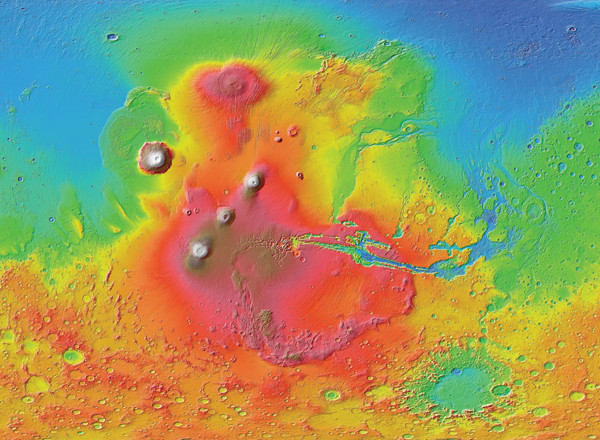
The high-elevation Tharsis region appears in shades of red and brown in this topographic map produced with data from the Mars Orbiter Laser Altimeter aboard NASA's now-defunct Mars Global Surveyor. Credit: NASA/JPL-Caltech/Arizona State University.
Thousands of kilometers across and bulging to elevations of almost 10 kilometers, the Tharsis region on Mars hosts several massive volcanoes and straddles the border between the planet’s northern lowlands and southern highlands. Some scientists have postulated that the bulge resulted from a stationary hot spot, or plume, of warmer-than-normal mantle rock beneath it, but a new study supports a competing idea that the hot spot migrated to its present position. Karina Cheung and Scott King of Virginia Tech University identified a plume pathway, based on measurements of crustal thickness and surface topography, from Mars’ south pole to the current Tharsis bulge. The pathway is characterized by thick crust underlying a relatively smooth stretch of surface that stands out from the surrounding pockmarked surface, and which may have resulted as plume-powered volcanism wiped out craters as it traveled north. The researchers noted in the Journal of Geophysical Research: Planets that the presumed Tharsis hot spot track resembles the path left by the Yellowstone plume as it has migrated under the western U.S.
East of Tharsis, the 7-kilometer-deep Valles Marineris scars Mars’ surface for more than 4,000 kilometers. The massive canyon’s origins have remained a mystery to scientists, although various explanations have been suggested, including that it was carved by flowing water, that it is a huge tectonic fault, or, perhaps most commonly, that it is a crack that resulted from stress on the crust due to heavy volcanic activity in the Tharsis region. But in a new study in the Journal of Volcanology and Geothermal Research, Giovanni Leone of ETH Zurich in Switzerland has hypothesized that Valles Marineris and the nearby area of spider-webbed valleys known as Noctis Labyrinthus originally formed as subsurface channels funneling lava away from Tharsis. When the pressure of lava in these tubes subsided, he suggested, their thin ceilings gave way. Subsequent lava flows along the same routes then incised the canyons further, resulting in the features we see today. In a statement, Leone, who analyzed satellite imagery collected by MRO for the study, noted that he expects “a spirited debate” with other scientists over the lava-tube notion.
Construction of NASA’s next Mars lander, InSight, is set to begin after the project passed its Mission Critical Design Review in mid-May. Scheduled for launch in March 2016, InSight (Interior exploration using Seismic Investigations, Geodesy and Heat Transport) will study Mars’ internal structure and investigate the formation of rocky planets using instruments that can detect seismic waves and heat flow through the planet’s subsurface. “We now move from doing the design and analysis to building and testing the hardware and software that will get us to Mars and collect the science that we need to achieve mission success,” said project manager Tom Hoffman of NASA’s Jet Propulsion Laboratory in Pasadena, Calif., in a statement. Like the Phoenix lander, with which InSight shares many design features, InSight will be built by Lockheed Martin in conjunction with NASA and the French and German space agencies.
© 2008-2021. All rights reserved. Any copying, redistribution or retransmission of any of the contents of this service without the expressed written permission of the American Geosciences Institute is expressly prohibited. Click here for all copyright requests.