
by Mary Caperton Morton Tuesday, September 19, 2017
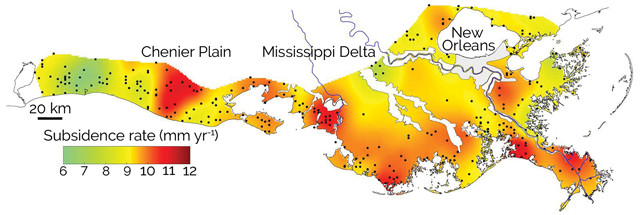
A new map of subsidence rates is helping scientists and policymakers chart land loss along the Louisiana coast. Credit: Nienhuis et al., GSA Today, June 2017.
Since the 1930s, Louisiana has lost an area of coastal wetlands larger than the state of Delaware. A new map, published in GSA Today, charts the land loss from a combination of man-made and natural factors, including reduced sediment flow from the Mississippi River, land subsidence and sea-level rise.
To create the map, Jaap Nienhuis of Tulane University in New Orleans and colleagues used data from hundreds of surface elevation tables installed along the Louisiana coast after Hurricane Katrina hit in 2005. The instruments allowed the team to accurately measure the rate of subsidence in the shallow subsurface. They found that since 2005, subsidence has occurred at a rate of 9 millimeters per year. Previously, subsidence rates had only been estimated by models, not measured in real time. The newly calculated present-day subsidence rates are higher overall than predictions based on modeling and tide gages, with higher than average subsidence rates occurring in the eastern Chenier Plain, the Atchafalaya and Wax Lake deltas, and along the Mississippi River downstream of New Orleans.
“This information will be valuable for policy decisions about coastal restoration, such as planning of large sediment diversions that are intended to make portions of Louisiana’s coast more sustainable,” Nienhuis said in a statement.
Subsidence of the land surface is a natural phenomenon seen along many coastlines as sediments compact under their own weight. In Louisiana, this is compounded by a lack of new sediment to balance the sinking in many areas, the researchers wrote. “While a variety of factors have contributed to Louisiana’s wetland loss problem, the fundamental culprit is the isolation of the sediment-delivery system (the Mississippi River) from its delta plain and the adjacent coastal zone due to the construction of flood-protection levees. As a result, most of the sediment carried by this system is funneled into the deep waters of the Gulf of Mexico, rather than offsetting the naturally occurring high subsidence rates,” they wrote.
© 2008-2021. All rights reserved. Any copying, redistribution or retransmission of any of the contents of this service without the expressed written permission of the American Geosciences Institute is expressly prohibited. Click here for all copyright requests.