
by Timothy Oleson Friday, August 21, 2015
Credit: NASA Earth Observatory/ Joshua Stevens.
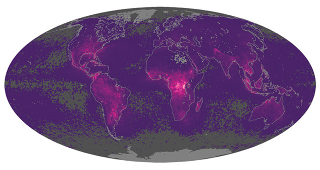
Lightning strikes far more often over land than sea and is more concentrated closer to the equator — both testaments to the greater atmospheric instability over those parts of the planet. These are just two observations evident from a global map of lightning strikes produced recently by NASA based on nearly two decades of data from the OrbView-1/Microlab satellite and the Tropical Rainfall Measuring Mission satellite. The new map color-codes Earth by the average number of lightning flashes seen annually per square kilometer — brighter colors mean more lightning — and refines earlier efforts based on fewer data. So where on Earth does lightning strike most? That would be in eastern Democratic Republic of Congo, which is struck roughly 150 times per square kilometer each year, followed by the area near Lake Maracaibo in Venezuela. If you look closely, you can also see the contributions of certain orographic features like the Himalayas and the Rockies on lightning-strike patterns.
© 2008-2021. All rights reserved. Any copying, redistribution or retransmission of any of the contents of this service without the expressed written permission of the American Geosciences Institute is expressly prohibited. Click here for all copyright requests.