
by Lauren Milideo Monday, July 15, 2013
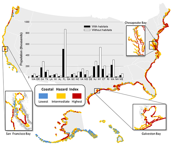
Map of United States, indicating coastal areas of greatest exposure to future hazards as determined by the new study using a Hazard Index. Areas in blue are least exposed to hazards; areas in red are most exposed. The bar graph indicates the population highly exposed to hazard with protecting habitats present (black bars), and the increased population exposed to such hazards if coastal habitats were lost (white bars). Courtesy of Katie Arkema, in Nature Climate Change (2013)
Devastating storms like Hurricanes Sandy and Katrina have left many coastal residents wondering how to protect life and property from future catastrophes. In a study published this week in Nature Climate Change, researchers suggest the best protection from storms and rising sea levels in the U.S. may entail a combination of engineering and conservation.
Recent storms show that “the traditional approaches to protecting our shorelines, such as seawalls, levees and coastal buffering don’t always do a sufficient job,” says lead author Katie Arkema, a marine ecologist for the Natural Capital Project at Stanford University, which is working to assess the value of services provided by Earth’s ecosystems. “This is a question that’s been bubbling up over the last few years,” she says: “What is the role of these coastal habitats in providing protection?”
First, Arkema and her team put together maps collected from local, state and national agencies to locate coastal habitats that might provide protection from hazards. The team next checked the scientific literature to assess and rank the amount of protection that each of these habitat types might provide.
They worked off of five sea-level rise scenarios, one current and four future; they used tide gauge measurements from 1992-2006 and the 2013 U.S. National Climate Assessment for the current scenario, and this assessment along with Global Sea-Level Rise scenarios from NOAA and an Intergovernmental Panel on Climate Change (IPCC) Special Report on Emissions Scenarios to build possible future scenarios.
After establishing these parameters, the authors created a Hazard Index — a means of assessing communities’ risks under measured and modeled conditions, reflecting the effects of habitat type, shoreline type, wind, waves, sea-level rise, storm surge potential and topographic relief on U.S. coastal communities. The authors constructed a map illustrating the locations most exposed, or having high hazard index scores, under likely future climatic conditions. The team then examined values of at-risk coastal properties under current and likely future scenarios, identifying differences in the values of residential properties falling within the highest-risk quartile of hazard risk scores (in this case, results summed by county).
The team found that, as sea levels rise, natural defenses such as coastal forests and shrubs become more important in many places, Arkema says. “An example of that is Monroe County [Florida] … where both coral reefs and mangroves become more important for protection.” In some other locations, habitat provides less protection, she says, likely because, “the protective services of these ecosystems can’t keep up with climate change.” Additionally, soft or flexible materials like submarine vegetation provide less protection than rockier coastlines, coastal forests and coral reefs.
Regionally, Arkema notes, the East Coast and the Gulf of Mexico regions face the greatest risk from storms and sea-level rise due to their “low-lying, soft habitats — mud flats, sandy beaches.”
Once the team had a good map of habitat type and potential hazards, the authors also looked at some of the social aspects of risk; they determined where natural habitat protects vulnerable populations. In Florida, a large proportion of the habitat-protected population includes elderly residents, while in Texas, it includes impoverished communities.
Natural habitat protects the most people overall, the largest vulnerable populations, and the largest overall property value in Florida, New York and California. If natural protective barriers were lost, increased numbers of people would be exposed to high risk from hazards in other states as well, including New Jersey, Connecticut and Massachusetts, among others. One of the most important findings of this study, Arkema says, is “a doubling of the numbers of people and values of property and vulnerable populations at risk” if natural ecosystems are lost. “This [assessment] is useful for planners and for people who are trying to decide what sort of investments to make in conservation, because it allows us to show where there is this relationship between ecosystems and vulnerable people,” she says.
This study takes a novel approach in addressing the question of where coastal habitats provide protection from hazard, says Vivien Gornitz of NASA Goddard Institute for Space Studies in New York, who was not involved with the study. It’s the first time that the habitat protection aspect of the U.S. shoreline has been studied, she says. This research demonstrates “the value of having as much natural habitat or coastline as possible in terms of potential protection against sea-level rise and storm surges,” Gornitz says. The study would be even more beneficial, she says, if the researchers were to compare storms’ effects along “stretches of shoreline that do or do not have natural habitat.”
Although this was a national-scale study, Arkema says the model could be run on smaller scales “to make more local and regional decisions.” She notes that such smaller-scale studies are underway for Florida and other states lining the Gulf of Mexico, where it is helping to guide the decisions of conservation groups and government officials undertaking activities under the RESTORE Act (the Congressional action to restore the Gulf Coast after the Deepwater Horizon oil spill). And in New York, New Jersey and Connecticut, the research is being employed to inform choices about where to focus conservation investments and efforts.
© 2008-2021. All rights reserved. Any copying, redistribution or retransmission of any of the contents of this service without the expressed written permission of the American Geosciences Institute is expressly prohibited. Click here for all copyright requests.