
by Martin Lockley Monday, April 18, 2016
Author Martin Lockley beside a Late Triassic trackway formed by an early sauropodomorph. The track was found at the base of the Wingate Sandstone in western Colorado. Credit: Martin Lockley.
For more than a century, the Western Slope of the Rocky Mountains where the mountains descend across the Colorado-Utah border onto the Colorado Plateau has proved a bountiful source of dinosaur fossils. In 1900, the giant Late Jurassic sauropod, <em class=““italic”>Brachiosaurus, was first found in the now world-famous Morrison Formation near Fruita, Colo. Bones in the dinosaur graveyard we now know as Dinosaur National Monument near Vernal, Utah, were discovered starting in 1908 with a <em class=““italic”>Diplodocus femur, followed in 1909 by a nearly complete <em class=““italic”>Apatosaurus and many more dinosaur bones over the ensuing years. These finds — along with multiple others closer to Denver in the late 19th century — set off a fossil-hunting bonanza across the West.
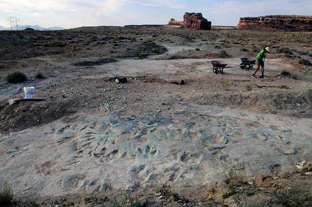
The Mill Canyon dinosaur tracksite in the Cedar Mountain Formation near Moab, Utah, has a variety of well-preserved tracks and is the most important Early Cretaceous tracksite in the Dinosaur Diamond. Credit: Martin Lockley.
President Woodrow Wilson designated the area east of Vernal as Dinosaur National Monument in October 1915. Studies and excavations continued at the site, and in 1938, President Franklin D. Roosevelt expanded the monument’s borders by 81,000 hectares, extending its reach into Colorado. In the 1960s, Price, Utah, got into the dinosaur game when the town bought a replica of an <em class=““italic”>Allosaurus — another Morrison Formation dinosaur — as a tourist attraction, helping found what is now the Prehistoric Museum. These sites — Fruita, initially a “Dinamation” site but as of 2000, the site of Dinosaur Journey, a branch of the Museums of Western Colorado, and Vernal, considered the gateway to Dinosaur National Monument — marked the eastern and northern corners of what became known as the “Dinosaur Triangle.” The museum in Price defined the western corner.
Then, in 1997 and 1998, respectively, the Colorado and Utah state legislatures independently designated a new “Dinosaur Diamond” scenic byway: an 824-kilometer-long roughly diamond-shaped dinosaur-sightseeing route that included Moab as its southern point. Moab had, by this time, become a bustling tourist destination mainly due to its proximity to Arches and Canyonlands national parks. Conceptually, the Dinosaur Diamond also included other neighboring communities like Blanding, Utah — about 120 kilometers south of Moab — which created its own Dinosaur Museum in 1995 . So, by 1998, with Blanding included as the southern corner, the Dinosaur Diamond had regionally important dinosaur museums at all four corners. In 2015, Moab got its own dinosaur museum called Moab Giants, which was built to celebrate the large number of dinosaur tracks — and the animals that made them — found in the region.
Should you find yourself in this neck of the woods, head to Dinosaur National Monument, Dinosaur Journey, or Prehistoric Museum for immersion in the Late Jurassic world of <em class=““italic”>Stegosaurus, giant sauropods and more, or make tracks to Moab Giants and Blanding’s Dinosaur Museum for stories, exhibits and experiences focused on tracks, trackmakers and the trackers — the paleontologists who specialize in tracks. The museums of the Dinosaur Diamond showcase the diversity of ancient habitats that reflect the varied geological landscapes of the area, and which continue to be illuminated in more detail with further scientific study and with each new find.
One of the best aspects of these museums is how they constantly adapt to new discoveries. Over the last century or more, paleontologists have gone from believing that dinosaur tracks were rare and of little scientific significance to recognizing that they are far more abundant than bones and are actually of fundamental importance in demonstrating behavior and providing census data on dinosaur communities. It’s all thanks to continuing excavations and discoveries.
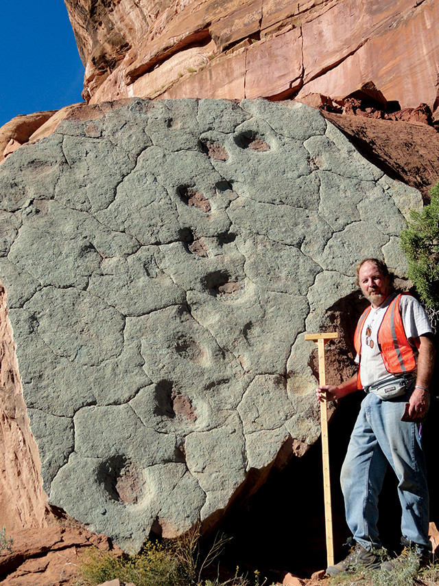
Small Late Triassic theropod tracks named Grallator from the Dirty Devil River Valley in Utah represent the early evolutionary radiation of small bipedal dinosaurs. Credit: Martin Lockley.
The general guideline employed by crime scene investigation detectives is to explore “means, motive and opportunity.” For dinosaur trackers, “means” refers to foot anatomy: Does the large five-toed track match up with the large five-toed foot? We can call this the Cinderella Syndrome, the fit of the shoe: A small three-toed animal can’t make big five-toed tracks. Likewise, opportunity is easily established. Only a Late Jurassic dinosaur could have made tracks during the Late Jurassic. Species from different epochs only coexist in science fiction movies like “Jurassic Park.” Motive is more difficult to discern. Can we get into the mind of a dinosaur to determine why it turned right rather than left, as in the Copper Ridge turning sauropod trackway? Why did a theropod run instead of walk? Was it chasing, or being chased?
In the Dinosaur Diamond region, some of the most important and most recent trackway finds have been around Moab and have been dated to between 210 million and 160 million years ago, spanning from the Late Triassic to the Early and Middle Jurassic. During the Late Triassic, the area was covered with lush subtropical habitats, giant horsetails, fish- and amphibian-filled lakes, and turkey- sized carnivorous dinosaurs like <em class=““italic”>Coelophysis, the New Mexico state fossil. This animal and its anatomically similar relatives left an abundance of small, birdlike three-toed tracks first reported in New England in the mid-1800s and called <em class=““italic”>Grallator. The earliest <em class=““italic”>Grallator tracks were all small. Thus track specialists recognized a zone of strata, found over much of the world, packed with small footprints from the dawn of the age of dinosaurs.
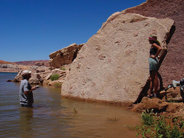
The author maps a Late Jurassic slab of Kayenta Formation sandstone with theropod tracks at Lake Powell, Utah. Credit: Martin Lockley.
We can follow the evolution of such early theropod dinosaurs through various family tree branches into the Jurassic formations represented in the Moab area. Here, larger theropod relatives left tracks, up to 45 centimeters long, such as <em class=““italic”>Eubrontes, literally meaning “true thunder” but loosely translated as “earth shaker.” The trackmakers that left <em class=““italic”>Eubrontes tracks were abundant at this time due to an evolutionary radiation of theropods, meaning there are many well-preserved examples to be found. Another interesting track, named <em class=““italic”>Otozoum, meaning “giant animal,” also found first in New England in the mid-1800s, was unknown elsewhere until examples were found in Moab in 1990. It represents a prosauropod, an ancestral relative of giant sauropods like <em class=““italic”>Apatosaurus and <em class=““italic”>Brachiosaurus, which themselves did not debut until the Late Jurassic.
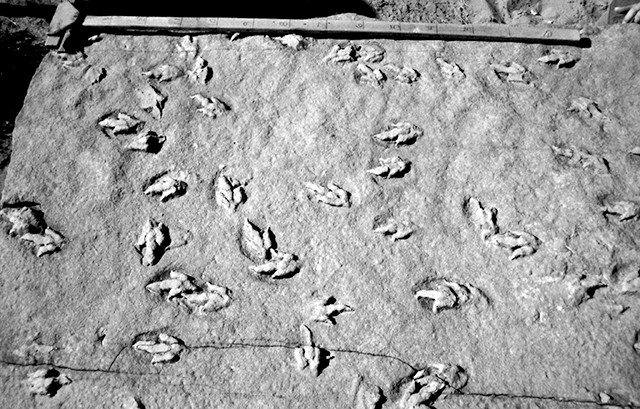
David Attenborough and a BBC crew film theropod tracks along the Moab Megatracksite in the Middle Jurassic Entrada Sandstone of eastern Utah. Credit: Martin Lockley.
Transitioning from the Late Triassic to the Early Jurassic, the rock record indicates that the region was covered in huge, Sahara-like deserts with endless tracts of scorching, barren sands. The famous Navajo Sandstone, seen at the entrance to Arches and along the Colorado River south of Moab, is the classic example of fossilized dunes. Thus, it was a surprise to learn in the 1970s that, in many areas, tracks of desert dwellers were quite abundant at hundreds of sites around Moab and all across southern Utah. Previously, paleontologists thought desert environments would have been too harsh to sustain trackmaking animals. It appears that while theropods and prosauropods roamed the intermittently dry water courses in interdune and small oasis areas where one might expect to find tracks, tracks of small rodent- and cat-sized protomammals (or synapsids), named <em class=““italic”>Brasilichnium, are common on the downwind, or lee, side of the ancient dunes. Their tracks also almost always point uphill, heading nose into the wind. No one really knows why this is.
The Early Jurassic theropod and prosauropod tracks <em class=““italic”>Grallator, <em class=““italic”>Eubrontes and <em class=““italic”>Otozoum, together with a small ornithischian track known as <em class=““italic”>Anomoepus, are typical of what has been called the first global track zone, or “biochron,” showing very similar track assemblages in the eastern U.S., Europe, Asia and Africa. However, it is only in the western U.S. that Early Jurassic protomammal tracks are common. This is because it is only in this region that these animals’ preferred sandy desert habitats prevailed at this time.
Desert habitats again prevailed during the Middle Jurassic when the Entrada Sandstone was deposited. The Entrada remains today as the main arch-forming rock formation in Arches National Park. Protomammals evidently disappeared throughout much of the world by this time, but we still find the small, three-toed tracks of crow-sized theropods.
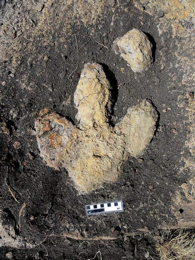
A very well-preserved three-toed ornithopod hind footprint and small front footprint from the Cretaceous-aged Dakota Sandstone near Delta, Colo. Credit: Martin Lockley.
As the Middle Jurassic drew to a close, the region remained a desert. However, a tongue of ocean, known as the Sundance Sea, flooded into the Moab area, creating a sandy shoreline on which we find millions of large theropod tracks. The area is puzzling from an ecological standpoint, because the footprint assemblage is completely dominated by tracks of predators, but none from potential prey. Perhaps this was a theropod-patrolled zone that prey species avoided. This extensive carpet of tracks has been named the “Moab Megatracksite” because it can be traced over several thousand square kilometers in Utah.
This widespread track layer has also popularly been referred to as the “Dinosaur Freeway.” The explanation of why there are so many tracks here is as much geological as biological; it has to do with rising sea level across a wide coastal plain. Counterintuitively, rising sea level does not wash away tracks. Instead, the sea acts as a dam allowing river and other shoreline sediment to accumulate along the coast creating coastal plain deposits — a process known as aggradation. As the sea transgressed farther over formerly dry land, dinosaurs tramped up and down the shifting coastlines, leaving behind millions of footprints. During this period, we also see evidence in preserved tracks for an influx of pterosaurs, which fed in the shallow waters and left their footprints on the ripple-marked shoreline sands.
In the Late Jurassic, the marine incursion began to regress, and the Western Slope of the Rockies became less arid. During this time, the Morrison Formation — comprising sandstones interbedded with soft mudstones — was deposited in a region extending from New Mexico to the Canadian border. The paleoenvironment was a broad mosaic of rivers, lakes, ponds and floodplain soils that offered suitable habitats for a diverse flora and fauna, including some of the world’s most famous dinosaurs like <em class=““italic”>Allosaurus, <em class=““italic”>Apatosaurus, <em class=““italic”>Diplodocus, <em class=““italic”>Brachiosaurus and the Colorado state fossil <em class=““italic”>Stegosaurus.
To this list of iconic creatures, all found abundantly in the Dinosaur Diamond area, we can add many other denizens of Morrison time, including the crocodilian <em class=““italic”>Fruitachampsa and the digging mammal <em class=““italic”>Fruitafossor, both named for Fruita, where they were found. Another famous denizen, especially in the Moab area, is the sauropod <em class=““italic”>Dystropheus, first identified by John Macomb’s 1859 expedition, which slogged from Santa Fe across rugged terrain to the confluence of the Green and Colorado rivers. This was 18 years before the discovery of dinosaur bones at Morrison, Colo., in 1877, often reported as the seminal discovery that opened the west to paleontological exploration and the infamous “Bone Wars” between paleontologists Othniel Marsh and Edward Cope.
Late Jurassic-aged Morrison paleoenvironments were not just dinosaur habitats, they were also home to a diverse fauna of small mammals and a flora often described as a fern- and cycad-dominated savanna. Unlike the theropod-dominated assemblages from the older Entrada Sandstone, the collection of tracks in the Morrison Formation make ecological sense. They include those of large and small theropods, sauropods and a few ornithischian dinosaurs, crocodiles and turtles, thus generally reflecting the presumed composition of the fauna, based on excavated bones.
As we step into the Cretaceous, we find ourselves in the 120-million- to 110-million-year-old Cedar Mountain Formation, which has proved highly productive for dinosaur remains in the Moab area. We also find tracks that match the skeletal record quite well. Theropod footprints include the first two-toed dromaeosaur tracks found in North America, quite possibly belonging to <em class=““italic”>Utahraptor, now an iconic Dinosaur Diamond discovery, for its large size. Sauropod and <em class=““italic”>Iguanodon-like tracks also match the skeletal record, but a dense assemblage of shorebird-like tracks is significant, because, as yet, the deposit has yielded no bird bones.
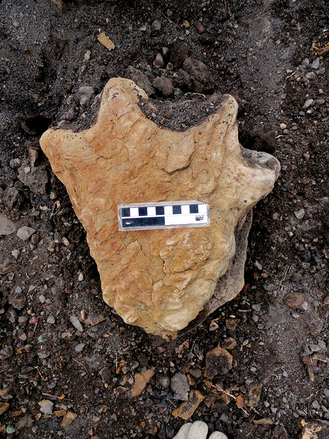
Well-preserved four-toed hind footprint cast of an armored dinosaur (ankylosaur) from the Cretaceous-aged Dakota Sandstone near Delta, Colo. Credit: Martin Lockley.
As we cross the boundary into the Late Cretaceous about 100 million years ago, we witness a major change in the paleoenvironment. A worldwide rise in sea level began flooding North America, creating the Cretaceous Western Interior Seaway. Trending north-south from the Gulf of Mexico to the Arctic, this shallow seaway helped create extensive coastal plain deposits on both its eastern and western shores. Rising sea levels again led to the accumulation and preservation of coastal plain deposits, which typically represent a mosaic of low-gradient wetlands, lakes, lagoons, floodplains and vegetation-rich coal swamps. Always wet underfoot, these were ideal habitats for preserving tracks, and this is exactly what we find in the track-rich Dakota Sandstone.
In Colorado alone, trackers have recorded more than 100 significant sites bearing tracks of birds, theropods, ornithopods, ankylosaurs, crocodilians, pterosaurs, turtles and even horseshoe crabs. Not a single sauropod track has been found, however. We don’t know exactly why, but sauropods disappeared from North America for about 30 million years, reappearing about 70 million years ago. This gap in the record is called the “sauropod hiatus.”
The track-rich beds of the Dakota Sandstone represent a huge dinosaur freeway — far larger than the Middle Jurassic example in southern Utah — extending from Kansas, Oklahoma and northeastern New Mexico across Colorado and into Utah. All tracks were not registered simultaneously across this vast area. Rather, as sea level rose and the shoreline advanced westward across the region, coastal plain deposits developed kilometer by kilometer. First thought to cover only eastern Colorado, scientists now realize that this is the mother of all dinosaur freeways.
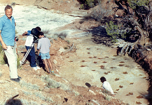
New evidence gives us tantalizing clues about how fast the coastline shifted as seas advanced westward across what is now the Dinosaur Diamond, as well as how many generations of dinosaurs wandered along this shifting shoreline. The latest big track discovery in the Dakota Sandstone comes from near Delta, Colo. It consists of dozens of large bowl-shaped excavations, up to 2 meters across, showing clear scrape marks made by the claws of both the left and right feet of large theropods. Clearly, these scrapes indicate a lot of energetic digging, but why? The only explanation that fits the evidence is that these features represent “nest scrape displays,” which are quite common today among various ground-nesting bird species. There don’t appear to have been actual nests at this site; the distinct claw scrapes were not smudged out by animals sitting in them for long periods during incubation, and there are no eggs, eggshells or remains of baby hatchlings.
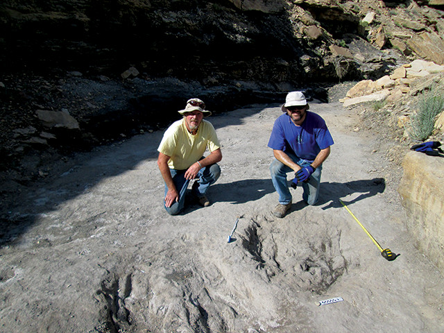
Researchers recently determined that these scrapes in the Cretaceous Dakota Group in western Colorado were made by theropod dinosaurs during courtship rituals. Credit: Martin Lockley.
Instead, this is a type of pre-nesting courtship behavior typical in the breeding season, presumably in the spring. Some birds, which are descendants of theropods, make hundreds of scrapes during their courtship rituals, showing off their nest-building abilities to prospective mates. The behavior suggests that Cretaceous theropods congregated in significant numbers at sites known as “display arenas,” or “leks,” to impress and claim mates. In frenzies of foreplay, males evidently made hundreds of scrapes before mating and settling down with their partners somewhere else, probably nearby, to nest.
The final chapter in the Western Slope dinosaur odyssey was written, appropriately, in the “Book Cliffs” mountain range that extends east-west across the Dinosaur Diamond from near Fruita to Price. Massive sandstones that make up the Late Cretaceous Mesa Verde Group represent extensive coastal plain deposits laid down as the Western Interior Seaway regressed back eastward across the area. Again, the region was well-vegetated and conducive to accumulation of peat and tracks. The peat was destined to become coal and drive the local mining industry, especially around Price, where 22 coal seams have been recorded. Theropod, hadrosaur, ceratopsian, pterosaur, bird and turtle tracks are common, along with the first frog tracks ever found from the Age of Dinosaurs.
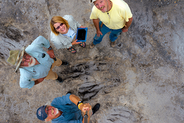
Colorado dinosaur trackers (counterclockwise from top: Martin Lockley, Neffra Matthews, Ken Cart and Brent Breithaupt) gathered around the recently discovered theropod scrapes. Credit: Neffra Matthews.
One odd set of tracks was found in the 1930s: Hadrosaur tracks up to a meter long led to wild speculation about giant and fast-moving mystery dinosaurs with monstrous 5-meter-long steps. The charismatic paleontologist Barnum Brown from New York’s American Museum of Natural History played up the mystery by excavating three giant slabs from a coal mine near Cedaredge, Colo., that fit together to show the supposedly long step. Fifty years later, paleontologists were still debating whether this represented a giant hadrosaur sprinting at about 27 kilometers per hour, or if the 5- meter span was a stride (accounting for two steps of 2.5 meters) at a more pedestrian stroll of about 8 kilometers per hour. Today, dinosaur trackers universally accept the 2.5-meter step length and slower speed.
Generations after dinosaurs were found in the Dinosaur Diamond, we know a lot more about these enduringly popular creatures and their tracks, but mysteries still remain. Pioneering paleontologists of our grandfather’s day could hardly have predicted that later trackers would find dinosaur freeways extending thousands of kilometers, where theropods whipped themselves into frenzies of sexual excitement during springtime courtship rituals. They likely would have been awed at the concept of a “Dinosaur Diamond,” connecting five dinosaur museums, each putting out online information at lightning speed. But some things they’d easily recognize are the bones, rocks and tracks that remain as tangible evidence of Earth’s treasures and prehistory.
© 2008-2021. All rights reserved. Any copying, redistribution or retransmission of any of the contents of this service without the expressed written permission of the American Geosciences Institute is expressly prohibited. Click here for all copyright requests.