
by Bethany Augliere Monday, December 12, 2016
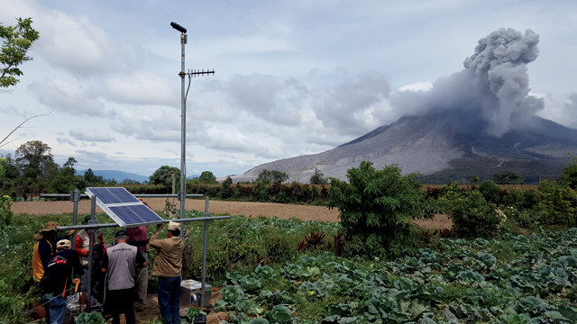
While Indonesia's Sinabung Volcano erupted, scientists from the Volcano Disaster Assistance Program (VDAP) and Indonesian colleagues installed Differential Optical Absorption Spectroscopy (DOAS) instruments — one of many projects VDAP officials have helped with at volcanoes around the world. DOAS, which measures the emission rate of gases, makes it possible to analyze emissions without approaching the dangerous and active summit of the volcano. Credit: Christoph Kern, USGS.
In early January 2009, volcanologist Gari Mayberry unexpectedly found herself aboard a flight to Africa alongside two colleagues. Just a few days earlier, the trip hadn’t been on her radar, but in late December, she had received a call from the acting director of the U.S. Agency for International Development’s (USAID) Office of U.S. Foreign Disaster Assistance (USAID/OFDA). Tanzania needed assistance assessing a potentially dangerous ongoing volcanic hazard — could she go?
Mayberry is part of the world’s only volcano crisis response team — a small group of U.S. volcanologists that works around the world to prevent eruptions from becoming disasters. The Volcano Disaster Assistance Program (VDAP) team, housed at the U.S. Geological Survey’s (USGS) Cascades Volcano Observatory (CVO) in Vancouver, Wash., is composed of about 20 volcanologists spanning disciplines from geochemistry to geophysics to petrology. The team — supported by USGS and USAID/OFDA, the latter a part of USAID — deploys internationally to work with local partners, respond to volcanic crises, assess volcanic hazards, install monitoring equipment, and train local scientists to forecast and monitor eruptions.
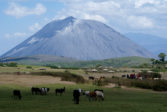
In June 2007, a stratovolcano in Tanzania began erupting, sending ash up to 18 kilometers into the skies and disrupting nearby communities. Standing 2,886 meters, Ol Doinyo Lengai, which means “Mountain of God” in the Maasai language, towers above the plains of the East African Rift Valley in northern Tanzania. It is the world’s only carbonate volcano and erupts a rare low-temperature carbonatite lava; the composition gives the hot lava a black appearance in sunlight, rather than the more common red glow. When the lava cools, it turns white. “There’s no other active volcano like it on Earth,” Mayberry says. For the next year, the volcano went through intermittent periods of eruptive activity.
Then, in late 2008, the Tanzanian government requested assistance from the U.S. Ol Doinyo Lengai was unmonitored, and the Tanzanian government was trying to determine if evacuations were necessary. “There was urgency in the sense that the activity could continue, and people could be in harm’s way,” says Mayberry, who, in addition to her role as a USGS volcanologist, is also a natural hazards advisor for USAID/OFDA, and serves as a liaison between the two agencies. “So, the [local] government wanted to make a decision.”
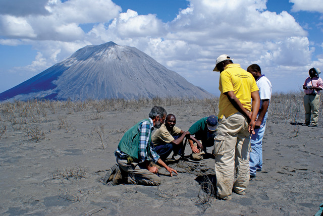
The three-person VDAP team visited Tanzania for two weeks in January 2009. To uncover the volcano’s eruptive history and assess the hazards at Ol Doinyo Lengai, they worked with scientists from the Geological Survey of Tanzania and the University of Dar es Salaam to search for evidence of previous pyroclastic flows. “That’s one way to figure out what the volcano might do in the future — to see what it had done in the past,” Mayberry says.
After a week in the field, Mayberry and the team reported that evacuations were not necessary. “The villages were in a location where they would not be impacted by pyroclastic flows — the super-heated avalanches of gas and ash that can be so deadly,” Mayberry says. At most, she says, the communities would have had to deal with ashfall, which is usually not fatal.
VDAP is not a scientific SWAT team that only swoops in during the action. They only respond when requested, and often the goal is to work with local scientists before a potential disaster is imminent to improve locals’ capacity to monitor their own volcanoes and provide eruption forecasts. “It’s their job, not ours, to mitigate their risk. We are there to support them,” says John Pallister, a USGS geologist and VDAP chief, based at CVO. With roughly 1,550 active volcanoes around the world, up to 20 eruptions in a given week, and global partnerships spanning 12 countries and 30 years, the team is always busy.
Ol Doinyo Lengai Volcano in Tanzania means "Mountain of God" in Maasai, the local language. It is the world's only active carbonate volcano. Credit: Gari Mayberry, USGS.
The idea of an international volcano response team had been swirling in the minds of scientists for years before its formation in 1986. Volcanic hazard analysis in the U.S. is credited to the work of two pioneering geologists, Dwight “Rocky” Crandell and Don Mullineaux, who uncovered the impending volcanic threat to the Cascade region in the 1950s. The volcanoes were known to be young, but there were limited data on the frequency of their past eruptions, Pallister says.
The two geologists were mapping part of the Puget Sound lowlands, southeast of Seattle, when they discovered lahar deposits from Mount Rainier. They pieced together that it erupted 5,600 years ago, sending the violent, rocky mudflows cascading 320 kilometers to Puget Sound and filling nearby valleys up to 120 meters deep.
Crandell and Mullineaux also discovered that Mount St. Helens averaged one to two explosive eruptions per century. In 1978, the pair predicted that Mount St. Helens would erupt in the next 20 years. It erupted two years later. After the eruption, USGS formed its Volcano Hazards Program. But it took another deadly disaster before an international response team was created.
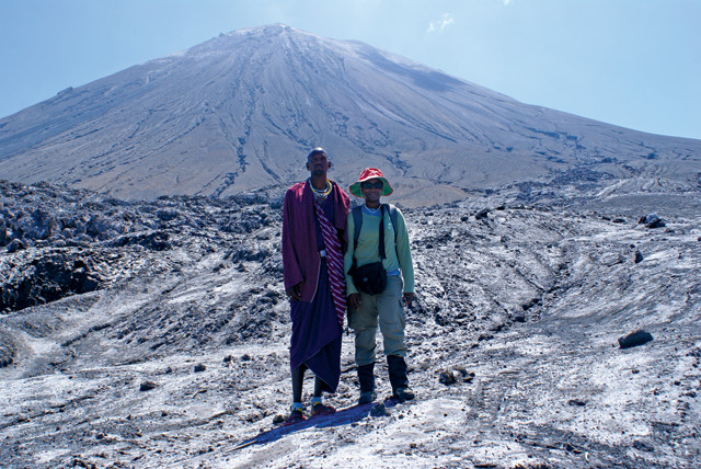
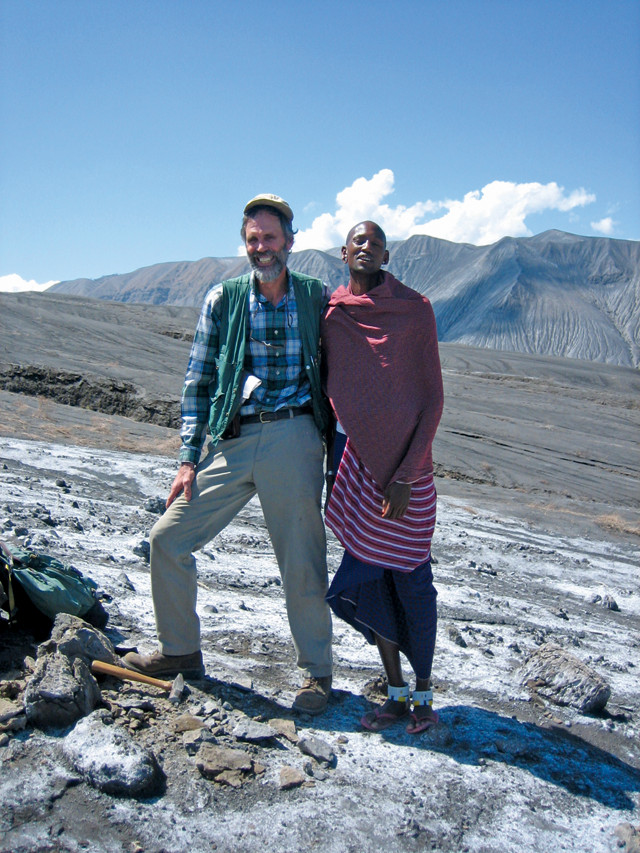
Gari Mayberry (shown here with a guide) deployed to Ol Doinyo Lengai in 2009 to help local scientists determine the eruptive history of the volcano and the potential hazards it posed to nearby villages. Credit: Thomas Casadevall, USGS.
On Nov. 13, 1985, Nevado del Ruiz, a volcano about 130 kilometers from Colombia’s capital, Bogotá, erupted and unleashed deadly lahars that killed more than 23,000 people, making it the second-deadliest volcanic disaster of the 20th century (behind the 1902 eruption of Mount Pelée on Martinique) and the fourth-deadliest in recorded history. The 1980 eruption of Mount St. Helens, which killed 57 people in CVO’s backyard, started “the revolution,” Pallister says. “It was that experience that qualified the people who were around to understand that Ruiz was a preventable disaster,” he says. In 1986, USGS came together with USAID/OFDA and created VDAP, the world’s only international volcano response team.
In recognition of the team’s efforts, VDAP was named a finalist for the 2016 Service to America Medals. “I’m really happy to see that VDAP is being recognized in this way, and the leadership of John Pallister is being recognized, because he has been a great leader and has helped the team focus on scientific diplomacy and building friendship and trust with counterparts,” Mayberry says. “Volcanoes are not something that most people think about regularly,” she says. “I want people to know that there is this team of people who are thinking about volcanoes regularly.”
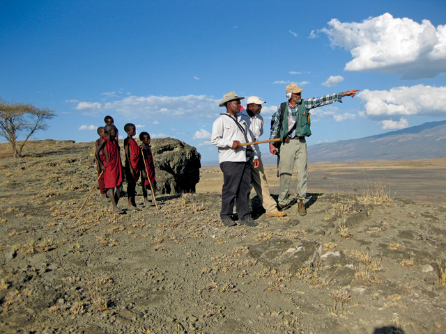
VDAP team member David Sherrod surveys Ol Doinyo Lengai with scientists from the Geological Survey of Tanzania while locals watch. Credit: Thomas Casadevall, USGS.
In the last decade, the VDAP team has grown from five individuals to about 20 core personnel, most of whom are full-time USGS employees. When needed, the team also taps other USGS experts and even USGS retirees.
When not deployed overseas, the team at CVO communicates with counterparts in other countries; builds, maintains and tests equipment; conducts scientific and hazard-mitigation research with domestic and foreign colleagues; and monitors remote-sensing data from more than 100 international volcanoes. In a typical week, VDAP collectively responds to about a dozen consultation requests from partners, ranging from specific questions about troubleshooting software or interpreting data, to broader requests to discuss signals of potential unrest, Pallister says.
The team maintains a cache of spare equipment at a CVO warehouse in Vancouver, including pre-packed seismometers, gas-monitoring systems and GPS systems, which include telemetry equipment for transmitting data from a field site back to an observatory. The equipment is continuously tested, so in the event of a volcanic crisis, the VDAP scientists can trust that it will work. “We strive to maintain an equipment cache adequate for two full-blown volcanic crises at all times,” Pallister says. How much gear is actually sent out depends on the situation and can range from a single FedEx package to a shipment of 20 or 30 trunks of equipment for a big crisis response, all packed to ship commercially or as checked luggage to facilitate rapid deployment. Once equipment is sent to a country, it is theirs to keep. So VDAP is continually buying new components and building the needed systems in-house.
About two-thirds of a VDAP responder’s job is done stateside in the office, leaving up to a third of the year when the scientists might be away from home.
In 2009, VDAP team members and scientists from the Geological Survey of Tanzania decided that nearby villages would not be impacted by pyroclastic flows from Ol Doinyo Lengai and that evacuations were not necessary. Credit: Gari Mayberry, USGS.
Deploying to the field can go one of two ways: unexpected and urgent, like Mayberry’s deployment to Tanzania in 2009; or planned, to provide support and training, as the team has been doing intensively since 2004 in Indonesia, where they work with scientists at the Center for Volcanology and Geological Hazard Mitigation (CVGHM). VDAP decides who will deploy in a given situation depending on the expertise needed and who is available.
Indonesia receives much of VDAP’s current focus, as the country hosts about 130 active volcanoes. “Indonesia is very, very densely populated, so there is high risk. The volcanoes are explosive — the most worrisome type,” Mayberry says. “It has the recipe for potential disaster, so it’s a high priority area for our work.”
In the last 12 years, VDAP has responded to four crises at three volcanoes in Indonesia, and has also helped improve monitoring capacity and train local scientists to install instruments, analyze data and create forecasts. For example, the group has installed seismic, GPS and gas-monitoring equipment at numerous high-risk volcanoes, including Mount Sinabung — a volcano in North Sumatra that exploded back to life in 2010 and has since been a site of ongoing monitoring in cooperation with local scientists. In May 2016, Sinabung erupted again, killing seven people. VDAP provided monitoring equipment and assistance with remote-sensing data, which helped inform the evacuation decisions made by VDAP’s Indonesian partners, Pallister says. Had it not been for them, the toll could have been much worse.
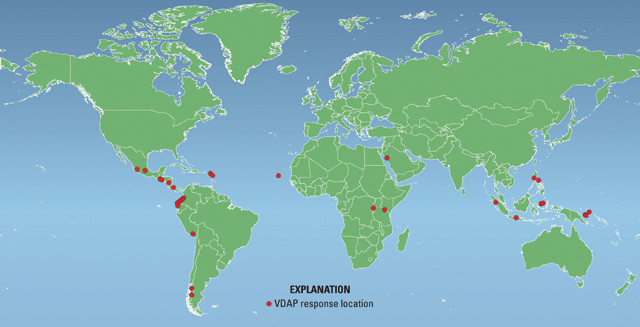
VDAP has responded to more than 30 major volcanic crises and strengthened capacity in 12 countries since its inception in 1986. Credit: USGS.
As part of VDAP’s continuing efforts in Indonesia, Christoph Kern, a research physicist with VDAP since 2014, traveled to Sinabung in August 2016 to help install new geochemical monitoring instruments and train local scientists on how to operate them.
Differential Optical Absorption Spectroscopy (DOAS) instruments measure the emissions rate of gases, primarily sulfur dioxide, from a relatively safe distance by analyzing sunlight that shines through the volcanic gas cloud. DOAS makes it possible to analyze emissions without approaching the dangerous and active summit of a volcano, says Kern, who helped develop the technology as a graduate student at the University of Heidelberg in Germany.
Sherrod and a local guide examine ash samples in Tanzania. Credit: Thomas Casadevall, USGS.
Gas emissions from a volcano can indicate its level of activity. Typically, as magma rises toward the surface, the pressure confining it drops, allowing dissolved gases to escape from the magma into the atmosphere. In the case of Sinabung — where almost all explosive eruptions trigger pyroclastic flows — studying the patterns of gas emissions could help scientists understand the mechanisms that lead to explosions and trigger deadly pyroclastic flows, and thus help improve scientists’ ability to predict such flows.
Kern and his colleagues hypothesize that cooling magma in the dome at Sinabung acts like a plug. If the magma cools enough, it can solidify enough to prevent gas from escaping, which builds pressure inside, Kern says, potentially leading to an explosion. “It’s pretty early, so we don’t have enough data to forecast the explosions that generate pyroclastic flows yet,” he says. “But we do have the data to see that gas emissions are quite low most of the time and much greater leading up to and during an explosion — that likely indicates this process of sealing or plugging is going on.”
Although the spectrometer technology was first developed more than a decade ago, it had not yet been implemented in Indonesia. So, Kern and a team from VDAP arranged to visit the country and work with scientists from CVGHM to install the instruments. For this project, VDAP shipped 40 crates of equipment weighing almost a ton to Indonesia, including the spectrometers, solar panels, batteries and other electronics.
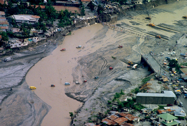
Mount Pinatubo on the island of Luzon in the Philippines erupted on June 15, 1991. The eruption lasted nine hours and was the second largest of the 20th century. VDAP members helped local officials decide to evacuate before the eruption. Credit: Chris Newhall, USGS.
Once there, Kern’s team, along with local scientists, spent a couple of days scouting for the best locations for the instruments and getting permission to install equipment. A good site requires a clean line of sight from the instrument back to the local volcano observatory, or to a “repeater” site from where data can then be sent to the observatory. But perhaps more importantly, Kern says, a good site requires a clear view of the sky downwind of the volcano. He and his colleagues eventually installed three gas-monitoring instruments about 6 kilometers from the summit of the erupting volcano.
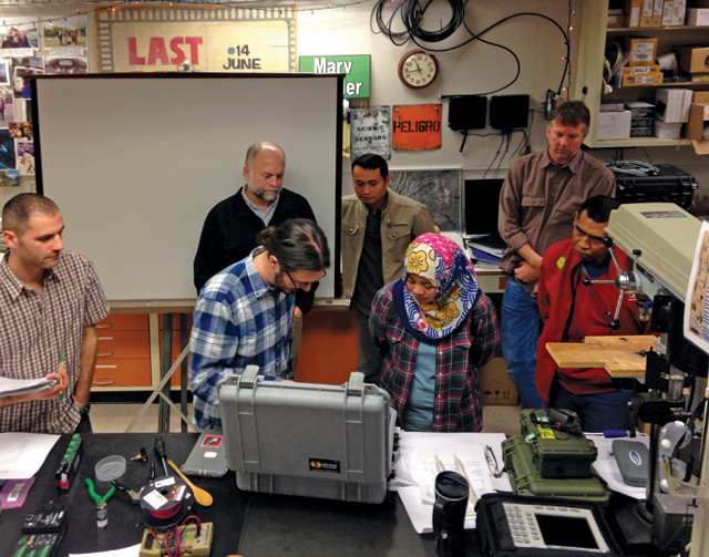
Indonesian Center for Volcanology and Geologic Hazard Mitigation scientists visited the VDAP base at the Cascades Volcano Observatory for instrument training. Credit: John Pallister, USGS/VDAP.
During the trip, Sinabung frequently spewed giant black clouds of ash. “I don’t know if I’ve worked at a volcano that’s been that active … while we were actually putting in our instruments,” Kern says. The eruptions underscored one of the advantages of the technique, he says: Because the equipment does not need to be placed very close to the active volcanic vent, the team could still work even while the explosive activity was happening.
Once the installation was complete, VDAP spent a week training the local scientists on how to analyze the data, with the goal being to eventually help forecast pyroclastic flows. Kern also went over potential pitfalls of the equipment and data. For example, the data can sometimes appear “dark,” suggesting it’s nighttime even during the day; that can result from something blocking the scanner of the instrument, such as volcanic ash. Clouds can also move between the instrument and the volcanic gas plume, blocking the plume, and giving the false impression that emissions are low. So, in that case, he says, “we might ask: ‘Is this really a case where gas emissions have shut off, or is it a thunderstorm?'”
Ideally, Kern says, these instruments would be everywhere, but VDAP must prioritize its resources. The gas monitors are placed at active volcanoes with the highest potential for disasters, as in Indonesia, and where scientists can immediately learn something from the measurements, he says.
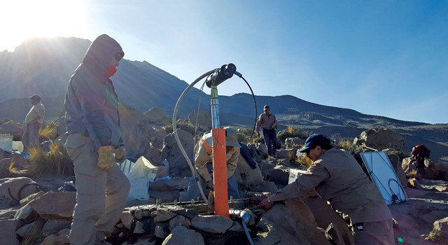
In May 2016, Christoph Kern traveled to Peru's most active volcanoes, Ubinas (seen here) and Sabancaya, to work with local scientists to install gas-monitoring instruments that measure the absorption of scattered light. Credit: Christoph Kern, USGS.
The month in Indonesia was gratifying, Kern says. “It’s rare that you can apply such an abstract physical science — spectroscopy — and know that what you’re doing is actually impacting people’s daily lives and potentially ensuring their well-being.”
The drive to help people is a common characteristic in VDAP staff, Pallister says. VDAP “attracts people who have a combined interest in better understanding of natural phenomena and wanting to use that [understanding] in an applied way to help people,” he says.
But working at VDAP can be stressful and exhausting, and it’s “easy to burn out,” Pallister says. VDAP’s responders can be away from home and family for long periods of time, and sometimes must work in harsh environments. While working in the Peruvian Andes at about 5,000 meters, for example, Kern suffered through altitude sickness. In addition to nausea, “I had insomnia. I would nod off, then wake up gulping for air,” he says. “After four days of no sleep and just cat-naps, I was really at the end of my [rope].”
The team also deals with life-or-death situations, and VDAP’s counterparts depend on the group’s advice to help make important decisions. And it’s hard when things don’t go according to plan, like when people were killed during the Sinabung eruption last May when they ventured into restricted zones. “This is both tragic and sad,” Pallister says. “However, one has to take these losses in context and, due to our Indonesian partners’ work, many more lives have been saved at Sinabung and at many other volcanoes.” nbsp;
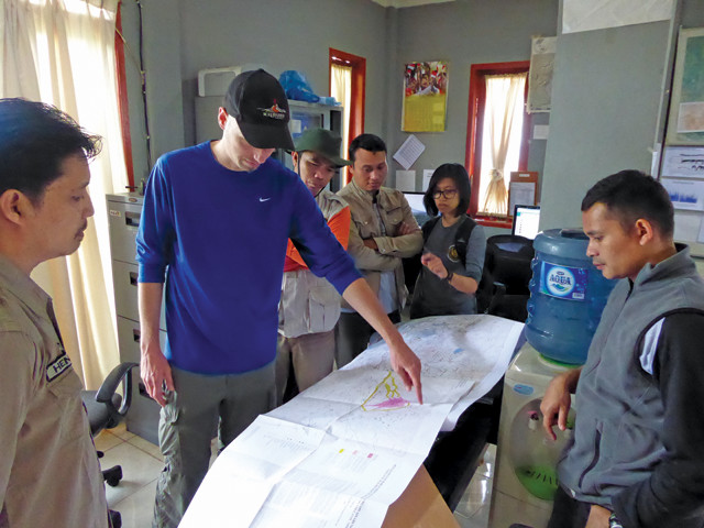
VDAP team member Christoph Kern discusses options for locating gas-monitoring instruments at the Sinabung observatory. Credit: Allan Lerner, USGS.
USGS geophysicist Andrew Lockhart has been with VDAP since its inception and knows the exhaustion of the job firsthand. He has traveled to at least 60 volcanoes in 12 countries. But lately, he has been deploying to the field less often, thanks to VDAP’s success in helping countries develop their own capacities to handle volcanic crises.
Lockhart specifically works on building seismic networks — consisting of seismometers, radios and solar panels — that use line-of-sight radio telemetry to transmit seismic signals back to the local observatory. The goal is to build seismic networks that are “plug-and-play” once they reach the host country, and that are also weather- and insect-resistant, Lockhart says. Ants, in particular, like to nest in the warm electronics. These networks are expensive, and small observatories may not have the resources to maintain them, he says.
In the past, Lockhart would build a network at CVO, then travel with the equipment to the country in need, where he’d then train the local scientists on how to use it. Now, many countries have the capacity — from prior training with Lockhart and others from VDAP — to install and monitor the equipment themselves, which means Lockhart and his colleagues can just ship it and then work remotely with local scientists as needed.
The monitoring improvements and self-sufficiency in many countries where VDAP has worked is one way to measure the program’s success, Pallister says. Of course, he adds, it is expected they will still call VDAP if there is a major event and if they need help. It just means that VDAP personnel may be able to help from their offices at CVO rather than traveling to the eruption site.
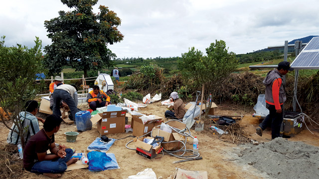
Indonesian scientists work to install a gas-monitoring site at Simalem, 6.5 kilometers northeast of Sinabung. Credit: Christoph Kern, USGS.
For example, in October 2010, when Mount Merapi in Central Java, Indonesia, began erupting, VDAP got the call — but that’s all it ended up being, phone calls, until after the eruption when a small team deployed to replace equipment. In the week leading up to a big eruption, Pallister was in frequent contact with officials from Indonesia via phone to provide information from satellite imagery. “It was like being there but not, and being just as worried about your friends as if you were right among them,” Pallister says. “Trying to advise someone who’s at his rope’s end in the middle of an incredibly intense situation” over the phone took some adjustment, he says. It was the first time that remotely sensed satellite radar information, provided by VDAP, played such an important role in forecasting a big eruption. And, in the end, these forecasts enabled the evacuations that saved lives. The explosion killed 300 people, but it could have killed thousands more if those evacuations were not made in the hours preceding the main eruption, he says.
Pallister says he is pleased with the international work VDAP does, but one place he hopes to see improvement is in collaborating with academic researchers involved in studying volcanoes. “Science diplomacy is all about building international friendships among scientists and public officials who have similar jobs and similar humanitarian goals,” he says, something he continues to stress to his staff.
Additionally, “I have pushed for closer coordination with our U.S. embassies and USAID missions to leverage our work and our humanitarian mission with U.S. diplomatic goals, and, hence, to build stronger relationships between our government and the governments of our foreign partners.” VDAP works in the background with local agencies responsible for issuing warnings, he says, and has spent years developing a good rapport with those partners.
© 2008-2021. All rights reserved. Any copying, redistribution or retransmission of any of the contents of this service without the expressed written permission of the American Geosciences Institute is expressly prohibited. Click here for all copyright requests.