
by Sara E. Pratt Thursday, June 13, 2013
An airborne geophysical survey has confirmed the discovery of an impact crater under the town of Decorah in northeastern Iowa. Adam Kiel, U.S. Geological Survey
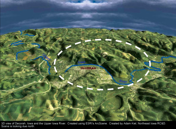
An airborne geophysical survey mapping mineral resources in the Midwest has confirmed that a 470-million-year-old impact crater nearly five times the size of Barringer (Meteor) Crater in Arizona lies buried several hundred meters beneath the town of Decorah, Iowa.
The crater’s existence was first hypothesized in 2008 when geologists examining cuttings from water wells drilled near the town were surprised to find evidence of a previously unknown shale deposit. When geologist Robert McKay from the Iowa Geological Survey investigated further, he found something even more surprising: The shale deposit was nearly a perfect circle, roughly 5.5 kilometers across. Further analysis of sub-shale breccias by Bevan French, a geologist at the Smithsonian’s National Museum of Natural History, revealed shocked quartz — a telltale sign of an impact. Together, the evidence added up to an exciting possibility: the existence of a previously unknown impact crater in the Midwest.
Earlier this year, more evidence accumulated when scientists at the U.S. Geological Survey (USGS) and the Iowa and Minnesota Geological Surveys conducted a high-resolution geophysical survey of the region to assess water resources and mineral resources. They were specifically mapping the Northeast Iowa Igneous Intrusive complex, which lies in the Midcontinent Rift System that formed about 1.1 billion years ago, and may contain valuable copper, nickel and platinum group metal resources.
The effort included electromagnetic and gravimetric surveys to detect conductivity and variations in rock density. The electromagnetic data revealed the full extent of the circular shale layer, likely deposited in the crater when the area was later flooded by an inland sea. Moreover, the gravity data showed “a textbook signature of a low-density feature, due to displaced bedrock in the crater, which corresponded with both the electromagnetic data and the borehole data,” says Andy Kass, a geophysicist at USGS in Denver, Colo., who analyzed the new geophysical data. “We now have three distinct datasets that all confirm the presence and geometry of an impact structure.”
“We were really lucky in this case that the shale layer was preserved within the crater, as it was eroded away nearly everywhere else,” Kass says. “If you travel to Decorah, you see a beautiful town, but certainly no impact structure.”
Given the diameter of the crater, it has previously been estimated that the impactor was a meteorite about 250 meters in diameter. The crater joins a suite of Middle Ordovician impact craters in the Midwest — including craters in Ames, Okla., Rock Elm, Wis., and the Slate Islands of Lake Superior in Ontario, Canada — that may, or may not, have resulted from the same impactor.
“It’s a tantalizing possibility,” Kass says. “Unfortunately, it’s impossible to use dating techniques to see if all the impactors happened on a single day.”
Statistically, he says, impactors of the size of those in the Midwest should hit somewhere on Earth every 30,000 to 60,000 years.
Kass continues to analyze the data to create a 3-D computer model of the crater to better understand its structural features, the geometry and energy of the impact, and whether it might be related to the other Midwest impact structures. “There is a lot of work left to be done,” he says.
“This is a major find with both scientific and societal implications,” says Douglas Howard, a planetary geologist and the associate program coordinator for StateMap and EdMap at the USGS National Cooperative Geologic Mapping Program, which funded the borehole research. The airborne geophysical survey was funded by the USGS Mineral Resources Program.
The discovery of a new extraterrestrial impact site is not only valuable to planetary geologists, Howard says, but also to hydrologists and resource planners modeling groundwater flow in the region. It also highlights one of the benefits of basic field research.
“As with a lot of geology,” Howard says, “until you get out there, you don’t know what you’re going to find under your feet.”
© 2008-2021. All rights reserved. Any copying, redistribution or retransmission of any of the contents of this service without the expressed written permission of the American Geosciences Institute is expressly prohibited. Click here for all copyright requests.