
by Mary Caperton Morton Tuesday, March 19, 2019
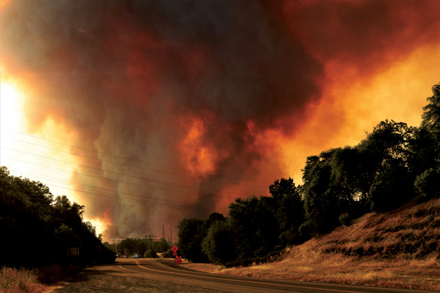
Over five weeks in July and August 2018, the Carr Fire in Northern California burned 930 square kilometers, killing eight people, destroying 1,600 buildings and causing .6 billion in damage. Credit: Eric Coulter, Bureau of Land Management.
At 7:30 p.m. on July 26, 2018, the Carr Fire, which devastated the Redding, Calif., region, reached a terrifying crescendo as tornado-strength winds spawned a 5-kilometer-high “firenado” of smoke, ash and fire that whirled on the edge of the city for more than half an hour. Fire-generated vortices of this size have only been observed a handful of times. The Carr Fire vortex is now the best documented to date, and a new analysis of satellite and radar data collected before, during and after the event is shedding light on how firenadoes form.
Small-scale fire whirls ranging from centimeters to meters across are common in wildfires, says Neil Lareau, an atmospheric scientist at the University of Nevada, Reno, and lead author of a new study, published in Geophysical Research Letters. “Most of these whirls are driven just by the heat of the fire, which acts to stretch out the column of air and concentrate any preexisting spin into a vortex.” But tornado-strength fire-generated vortices, also known as pyrotornadoes, are much rarer.
During the Carr Fire, NOAA’s GOES-16 satellite and three National Weather Service Next Generation Weather Radar stations captured the first detailed look at the formation of a firenado. The remote-sensing tools revealed a vortex with wind speeds up to 64 meters per second, or 230 kilometers per hour — equivalent to an EF-3 tornado. The vortex, which appeared on the northeastern flank of the fire, spread flames and caused extensive tornado-like damage. The firenado was directly responsible for four deaths, numerous injuries and staggering property losses.
In the new study, Lareau and his colleagues report how the firenado’s high winds were driven not just by heat from the fire, but also by the formation of a fire-generated, thunderstorm-like cloud called a pyrocumulonimbus cloud. “These bright white clouds forming at the top of the [existing tornadic] column reinvigorated the updraft from the fire and elevated the [tornadic] plume from a height of 4.5 kilometers to 12 kilometers in a matter of 15 minutes,” Lareau says. This process is similar to the development of a tornadogenic thunderstorm. A pyrocumulonimbus cloud playing a role in the creation of a firenado has only been observed once before, during the Canberra Firestorm of 2003 in New South Wales, Australia. But that event was not well recorded by remote-sensing instruments, Lareau says.
The Carr firenado lasted about 35 minutes, not an uncommon duration for an EF-3 tornado. “Tornadoes can last this long or longer, as long as large-scale organizing mechanisms are in play,” Lareau says. For large tornadoes, wind shear helps organize storms into long-lived systems. “In this case, the organizational mechanism is the fire itself,” he says. “Once you get these strong inflow winds fanning the flames, that increases the combustion rate and the intensity of the fire goes way up, which further intensifies the vortex, which further intensifies the fire. And you’re off to the races in this positive feedback loop.”
If California wildfires grow more intense due to long-term drought and dry forest fuels, the California Department of Forestry and Fire Protection (CalFire) may face the possibility of seeing more firenadoes in the future, says Michael Gollner, a fire protection engineer at the University of Maryland who was not involved in the new study. “As the number of extreme fires continues to increase, we’re probably going to see an increase in rare fire behavior. And the sobering reality is that these extreme fire events aren’t taking place in remote places,” Gollner says. “They’re burning in urban and suburban settings and causing unprecedented levels of destruction.” In total, the Carr Fire burned 930 square kilometers over five weeks in July and August, killing eight people, including three firefighters, destroying 1,600 buildings and causing $1.6 billion in damage.
“This study is a great window into how unusual fire behavior evolves, and it demonstrates how much we can learn when these fires are properly monitored using remote sensing,” Gollner says. Better remote-sensing coverage, coupled with more accurate models of fire behavior, are needed to make informed decisions about evacuation strategies and to widen safety margins for CalFire personnel on the ground, he says. “At this size and scale, we can’t fight these fires. Getting people out of harm’s way is often all we can do.”
© 2008-2021. All rights reserved. Any copying, redistribution or retransmission of any of the contents of this service without the expressed written permission of the American Geosciences Institute is expressly prohibited. Click here for all copyright requests.