
by Lauren Milideo Thursday, August 21, 2014
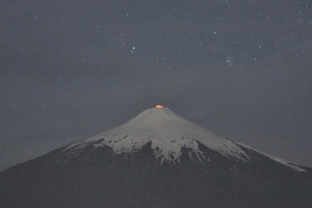
Only rarely can scientists get a view of the lava lake atop Villarrica volcano. Credit: Greg Waite.
The rises and falls of volcanic lava lakes are not easily tracked, especially when the lakes aren’t visible from crater rims. But recently, researchers found a way to monitor the lava lake at Chile’s Villarrica volcano using complementary methods to keep an eye on a feature they can’t always see.
“Our main motivation was to model the seismic and infrasound signals associated with bubbles moving through the [volcanic] system,” says Greg Waite, a seismologist at Michigan Technological University and co-author of a new study describing the efforts at Villarrica in the Journal of Geophysical Research: Solid Earth. Villarrica, a stratovolcano in Chilean Andes, is an ideal research location because, although it’s active, it is considered safe enough for workers to approach its summit, Waite says.
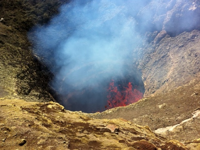
Sensitive instruments have helped researchers determine the levels in this lava lake atop Villarrica. Credit: Greg Waite.
Additionally, “it is one of the loudest infrasound-producing volcanoes on the planet,” notes Jeffrey Johnson, a volcanologist at Boise State University who was not involved with this project.
As often happens in science, the new study grew out of unanticipated patterns seen within data. The team had planned to study the volcano’s upper conduit, using infrasound and seismic signals created by large bubbles, or “slugs,” moving through and bursting at the surface of Villarrica’s open lava lake. But, Waite says, what he and his colleagues observed was a repeated time delay between the arrival of seismic signals moving directly through rock to a sensor and corresponding infrasound signals, which followed an airborne path — up through the conduit and then down the outside of the volcano — to the infrasound sensor at the same or a nearby location. When you set out to do one thing and end up finding something else interesting that you didn’t expect, “that can be pretty exciting,” Waite says.
That there would be a delay wasn’t unexpected — seismic signals travel faster than infrasound. More intriguing, Waite says, was that “that time difference wasn’t always constant.” The team compared infrasonic and seismic data from stations on the volcano’s side to understand differences in the different signals’ paths to the sensors. They assumed each set of seismic and infrasonic signals originated simultaneously, Waite says, and then estimated the signals’ velocities, which yielded differences in the distances traveled by each. Due to its higher velocity, changes in the seismic signal’s path were assumed to be negligible, leaving changes in the infrasound signals’ path to explain differences in arrival times at sensors. The team concluded that lake level fluctuations were responsible for the changes in infrasonic paths.
Next, to understand the background infrasonic tremor (unrelated to bubble-bursting events), the team modeled the volcano’s upper conduit, through which the infrasound traveled, as a Bessel horn (based on a trumpet’s horn shape). The team estimated the distance signals traveled through air (the horn’s length), providing a proxy for the depth of the lava lake below. Using known variables including the conduit dimensions and the speed of sound, they calculated sound frequencies based on varying lake depths. As the lake rose, the frequency rose; as it fell, the frequency fell. Changing infrasound frequencies could be correlated to shifting lake depths through time.
“One of the reasons [the new technique] is so fundamentally valuable is because there is no other convenient means of tracking where this [lava lake] surface is,” Johnson says.
The processes studied are occurring in the upper portion of the volcano, but, Waite says, once they have a better grasp of what’s happening in that part, they can apply their method to hopefully “understand the deeper processes at Villarrica, and hopefully translate that to other volcanoes as well.”
No eruption is immediately anticipated at Villarrica. But it is “a glacier-clad volcano, so even a very small eruption could melt a lot of ice and [produce] lahars that would travel down the volcano and that could do a lot of damage at much greater distances,” Waite says, so monitoring its lake is important. The research also provides a potential means of identifying lava lake level changes, which could signal hazards, at other locations. “It would be nice to try this [method] at another open-neck volcano with an active lava lake and see if we can do similar things,” Waite notes.
Indeed, the work shows “potential for long-term monitoring capabilities of hazardous volcanoes,” Johnson notes. “Not every volcano study has a direct link to keeping tabs on volcanoes that are going through periods of unrest, but this particular one does.”
© 2008-2021. All rights reserved. Any copying, redistribution or retransmission of any of the contents of this service without the expressed written permission of the American Geosciences Institute is expressly prohibited. Click here for all copyright requests.