
by Mary Caperton Morton Tuesday, June 5, 2018
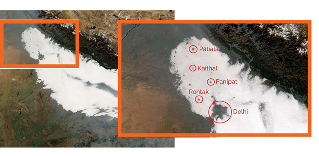
Widespread fog blankets northern India in this image captured by the Moderate Resolution Imaging Spectroradiometer on NASA's Terra satellite on Dec. 7, 2016. Fog holes over several major cities are visible. Credit: NASA.
Air pollution boosts fog formation in some places, creating whiteouts that can affect air and ground transportation, air quality, and public health. In northern and eastern India, persistent fog often hovers over the Indo-Gangetic Plain, a vast region dotted with several densely populated cities, including Delhi, home to 19 million people. Over some of these cities, however, satellite imagery is revealing large holes in the fog.
In a new study in Geophysical Research Letters, researchers attribute the fog holes to the urban heat-island effect: Cities are often significantly warmer than surrounding rural areas because concrete and other building materials absorb more sunlight — and subsequently radiate more heat — than bare ground and plants. Heat islands warm the lowest zone of the atmosphere, called the boundary layer, and reduce humidity, leaving less moist air available to form fog, the researchers suggest. Drawing upon 17 years of satellite images of the Indo-Gangetic Plain, “we found a very strong correlation between … the population of the cities and the fog hole area [above them],” said lead author Ritesh Gautam of the Environmental Defense Fund in Washington, D.C., in a statement. “We found the largest and most frequent holes in fog over Delhi.”
© 2008-2021. All rights reserved. Any copying, redistribution or retransmission of any of the contents of this service without the expressed written permission of the American Geosciences Institute is expressly prohibited. Click here for all copyright requests.