
by Timothy Oleson Wednesday, September 21, 2016
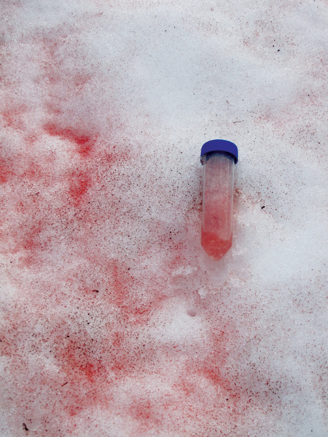
At glaciers and snowfields around the Arctic, researchers sampled snow tinted by red algae, which bloom in spring and summer and contribute to lowering surface albedo. Credit: Liane G. Benning, GFZ.
From Antarctica to the Arctic; from polar caps, permafrost and glaciers to ocean-rafted sea ice; and from burly bears to cold-loving microbes, fascinating science is found in every nook and crevasse of Earth’s cryosphere, and new findings are announced often. Here are a few of the latest updates.
The old adage about a red sky in the morning has long been familiar to sailors. Now, ice scientists studying melting Arctic glaciers may have an equivalent axiom: Red snow in the summer is a serious bummer. Previous research has shown that red-pigmented algae can thrive in snow, blooming during the warm glacial melt season and further reducing the amount of sunlight reflected — the albedo — by snow and ice fields. Melt ponds and crevasses, as well as snow-darkening particulates like soot and dust, also reduce albedos, causing glacial surfaces to warm and melt. In the widest biogeographical study of red snow algae yet, researchers sampled 16 glaciers and snowfields in Greenland, Iceland, northern Sweden and Svalbard, where they found red snow. They reported in Nature Communications that the compositions of the distant algal communities were all “highly similar,” and estimated that the algae could decrease snow albedo by up to 13 percent over the course of a melt season. “Our results point out that the ‘bio-albedo’ effect is important and has to be considered in future climate models,” said lead author Stephanie Lutz of the University of Leeds in England and the GFZ German Research Center for Geosciences in a statement.
Researchers peering beneath thousands of meters of ice to study the subglacial land surface of southern Greenland have revealed a giant, previously unknown drainage basin covering a fifth of Greenland that is about the size of the Ohio River Basin in the U.S. Michael Cooper of the University of Bristol in England and colleagues analyzed the landscape’s topography and likely hydrologic flow patterns using airborne ice-penetrating radar and satellite altimetry data, mapping out a roughly 443,000-square-kilometer dendritic basin. “The drainage basin we discovered shows signs of being carved by ancient rivers, prior to the extensive glaciation of Greenland [about 3.8 million years ago] … rather than being carved by the movement of ice itself,” Cooper said in a statement. Thus, the basin — which funnels toward Jakobshavn Isbrae, Greenland’s largest outlet glacier — has probably played a major role in controlling ice flow from the island’s interior to its margins over several glacial cycles, the researchers wrote in Geophysical Research Letters.
Monitoring the positions of ice sheet grounding lines, where the base of the ice lifts off the ground and floats in water, gives scientists a measure of ice sheet stability and an indication of whether the sheet is likely to gain or lose mass. Advancing or stationary grounding lines often indicate that an ice sheet is growing or stable, while retreating grounding lines typically mean thinning and melting. In a new study in Geophysical Research Letters, scientists looked at Landsat satellite imagery of the Antarctic coast along the Bellingshausen Sea — southwest of the Antarctic Peninsula — dating back to 1975 to gauge grounding line shifts. They reported that between 1990 and 2015, about 65 percent of the length of the grounding line in this area showed a net retreat while just 7.4 percent advanced. (Data available prior to 1990, which were limited spatially relative to post-1990 data, agreed with the later trend.) The most pronounced retreats, estimated at up to 2.8 kilometers over the last quarter of a century, were observed in locations previously identified as areas where the ice sheet is thinning, probably due to incursions of warm ocean water beneath the ice. Overall, the retreat is more pervasive “along the entire [Bellingshausen Sea] coastline than has previously been reported,” wrote Frazer Christie of the University of Edinburgh in Scotland and colleagues.
© 2008-2021. All rights reserved. Any copying, redistribution or retransmission of any of the contents of this service without the expressed written permission of the American Geosciences Institute is expressly prohibited. Click here for all copyright requests.