
by Timothy Oleson Wednesday, October 18, 2017
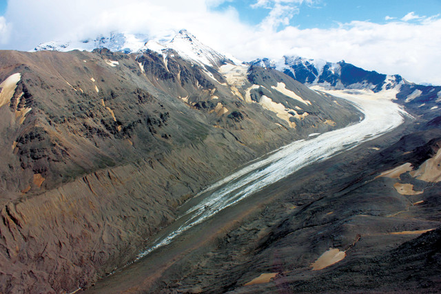
Jarvis Glacier flows from Mount Silvertip in the eastern Alaska Range. Runoff from mountain glaciers supplies water to streams and recharges aquifers in Alaskan watersheds. Credit: Anna Liljedahl.
From Antarctica to the Arctic; from polar caps, permafrost and glaciers to ocean-rafted sea ice; and from burly bears to cold-loving microbes, fascinating science is found in every nook and crevasse of Earth’s cryosphere, and new findings are announced often. Here are a few of the latest updates.
Researchers at the University of Edinburgh in Scotland reported evidence of 91 previously unknown volcanoes lying beneath the West Antarctic Ice Sheet (WAIS). Added to the 47 already known in the region, most of whose peaks breach the ice surface, the newly identified subglacial volcanoes raise the inventory of West Antarctic volcanoes to 138. The scientists first analyzed existing subglacial topographic data obtained through airborne radar sounding flights to identify cone-shaped features poking into the base of the ice sheet. To determine which features were likely volcanoes, they compared their observations to satellite imagery and to magnetic, gravitational and geological data from known volcanoes. The newfound volcanoes range in height from about 100 to 3,850 meters and are concentrated around the West Antarctic Rift System, the team reported in a study published in a special publication of the Geological Society of London. The researchers, led by undergraduate Maximillian van Wyk de Vries, noted that current activity levels of the subglacial volcanoes aren’t known, but that future thinning of the WAIS — and, thus, decreasing pressure on subterranean magma chambers — could lead to enhanced volcanism, which in turn could contribute to further destabilization of the WAIS.
Unlike Arctic sea ice, which has steadily declined in recent decades, Antarctic sea-ice coverage has actually increased slightly over the same period. But in austral spring 2016, Antarctic sea ice experienced record rates of decline. Ultimately, the melt-off culminated late in the austral summer when Antarctic sea-ice coverage shrank to the lowest level seen since satellite observation began in 1979. From September to November 2016, sea-ice coverage decreased by 75,000 square kilometers per day — a rate 46 percent faster than the average austral spring rate in the satellite era, according to a study in Geophysical Research Letters. The rapid rate resulted in a loss of 2.25 million square kilometers of sea ice during the three-month period, a drop that exceeded the average by 28 percent. John Turner and colleagues from the British Antarctic Survey analyzed the precipitous late-2016 decline and its possible causes. They found that it “coincided with a series of record atmospheric circulation anomalies over the three months,” which brought bursts of warm air to different parts of the Antarctic. Warm sea-surface temperatures near the ice at the time also likely contributed, they noted. Based on climate modeling, Antarctic sea ice is expected to experience long-term declines with rising global temperatures. However, Turner and his colleagues wrote that “it is still too early to clearly identify” the extent to which long-term warming may have contributed to the anomalous melting in 2016.
In a new study, researchers investigating a glacier-fed watershed in the eastern Alaska Range shed light on previously unseen connections among local glaciers, streams and aquifers. Anna Liljedahl of the University of Alaska Fairbanks and colleagues collected field observations from two headwater streams — Jarvis and Phelan creeks — in the Tanana River watershed to the southeast of Fairbanks. The researchers reported in Geophysical Research Letters that glacial runoff supplies a large share of the annual creek streamflow, even when only a small portion of the landscape draining into a creek is actually glaciated. They also found that roughly half the annual streamflow in the creeks infiltrates into the ground to recharge the underlying aquifer rather than continuing to flow downstream at the surface. As this aquifer is the only source feeding the lowland Tanana River in winter, when the landscape is otherwise frozen, the researchers wrote that the results show the year-round, and previously underappreciated, significance of glaciers in the hydrology of the watershed. The study also suggests an explanation for puzzling observations of increased wintertime flows in some Arctic and sub-Arctic rivers in recent decades. “The winter discharge of the Tanana River has increased since the record keeping began in the ‘70s, but there are no increasing trends in precipitation,” Liljedahl said in a statement. “Glacier coverage has, on the other hand, decreased by 12 percent, and that is more than plenty of additional water to explain the increase in river base flow.”
© 2008-2021. All rights reserved. Any copying, redistribution or retransmission of any of the contents of this service without the expressed written permission of the American Geosciences Institute is expressly prohibited. Click here for all copyright requests.