
by Timothy Oleson Friday, January 15, 2016
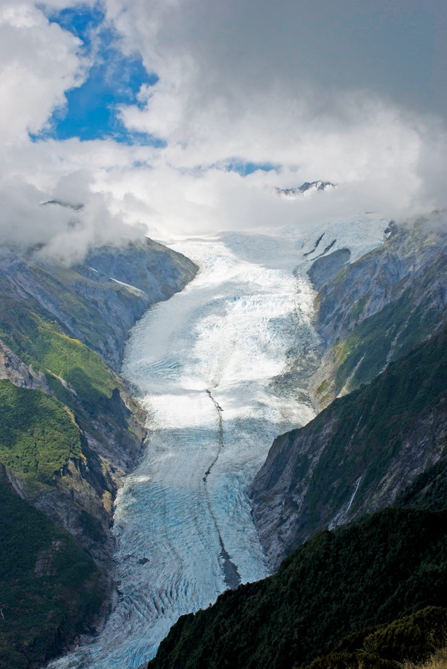
Based on a study of New Zealand's Franz Josef Glacier, researchers have developed a novel numerical law to describe glacial erosion rates on Earth. Credit: Frédéric Herman.
From Antarctica to the Arctic; from polar caps, permafrost and glaciers to ocean-rafted sea ice; and from burly bears to cold-loving microbes, fascinating science is found in every nook and crevasse of Earth’s cryosphere, and new findings are announced often. Here are a few of the latest updates.
Two new 300-year-long ice-core records suggest that snowfall over part of coastal West Antarctica increased dramatically through the 20th century compared to the preceding two centuries, when it was stable. From 1900 to 2010, annual snow accumulation rose roughly 30 percent in Ellsworth Land, near the Bellingshausen Sea, reported Elizabeth Thomas of the British Antarctic Survey and colleagues in Geophysical Research Letters. The researchers attribute the increase to the strengthening of a long-lasting regional low-pressure system, called the Amundsen Sea Low, which pushes warm, moist air onshore. The extra snow has not compensated for the loss of glacial mass measured in recent years, however. “The same [storms] that have driven increased snowfall inland have brought warmer ocean currents into contact with West Antarctica’s ice shelves, resulting in rapid thinning,” Thomas said in a statement.
Deep fjords, rocky moraines and streams clouded by fine sediment are all reminders of glaciers’ ability to shape Earth’s surface through erosion. Decades of study and modeling, however, have yet to provide a consistent picture of how different physical factors govern glacial erosion. In a study published in Science, Frédéric Herman of the University of Lausanne in Switzerland and colleagues propose a novel numerical law governing glacial erosion rates, suggesting that such rates are proportional to the square of the velocity at which ice slides over the ground below it; the velocity, in turn, primarily depends on ice thickness and topographic steepness. The researchers determined the new erosion rate law based on a five-month study of the Franz Josef Glacier on New Zealand’s South Island, during which they measured ice velocities and bedrock erosion rates across the glacier through remote sensing and sediment-load monitoring in glacial outwash streams. The wide range of erosion rates observed in the study suggests the rate law may be globally applicable, the researchers noted. Additionally, the law “may explain why glacial erosion rates span several orders of magnitude, from polar dry regions to temperate alpine glaciers and from soil-mantled hillslope landscapes to steep, tectonically active mountain ranges.”
A new study investigating an interior portion of the Greenland Ice Sheet (GIS) indicates that levels of snow-darkening particles, which absorb sunlight and decrease the albedo (the ability of a surface to reflect sunlight) of snow and ice, have not risen significantly in the last few years, relative to recent decades. Based in part on satellite observations from NASA’s MODIS instruments indicating that the albedo of the interior of the GIS has declined since 2001, scientists had blamed black carbon and other dusts settling out of the skies for contributing to the recent rapid loss of mass from the ice sheet. In the new work, published in Geophysical Research Letters, a team led by Chris Polashenski of Dartmouth College and the U.S. Army Corps of Engineers Cold Regions Research and Engineering Laboratory sampled near-surface snow that had fallen between 2012 and 2014 in 67 locations in the northwestern interior of the GIS. The researchers reported finding “no evidence that would support a hypothesis that observed inter-annual to decadal trends in albedo are being caused by changes in the deposition” of black carbon or dust. Rather, they concluded, the albedo decline seen in the satellite data is likely an artifact of degradation of MODIS sensors. Polashenski and colleagues noted, however, that the albedo of the GIS overall, including the ice sheet’s periphery, is still declining due to increased melting at lower elevations.
© 2008-2021. All rights reserved. Any copying, redistribution or retransmission of any of the contents of this service without the expressed written permission of the American Geosciences Institute is expressly prohibited. Click here for all copyright requests.