
by Timothy Oleson Thursday, November 12, 2015
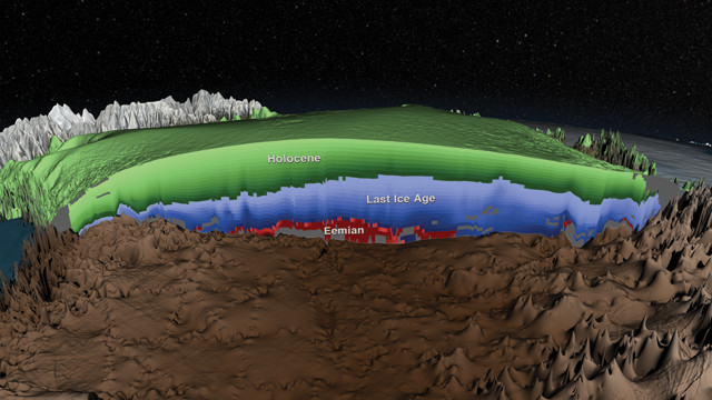
A comprehensive survey of the Greenland Ice Sheet using two decades of ice-penetrating radar data has yielded a three-dimensional view of the internal structure and age of the ice sheet's layers. Credit: NASA's Scientific Visualization Studio.
From Antarctica to the Arctic; from polar caps, permafrost and glaciers to ocean-rafted sea ice; and from burly bears to cold-loving microbes, fascinating science is found in every nook and crevasse of Earth’s cryosphere, and new findings are announced often. Here are a few of the latest updates.
Using two decades’ worth of deep ice-penetrating radar data, scientists have now surveyed the internal structure of the Greenland Ice Sheet on a larger scale than ever before. Previous efforts to map localized portions of the ice sheet using radar, which reflects off ice layer boundaries, have yielded insights about the age and behavior of the ice in some areas — important information for ice-flow and climate models. But recent surveying efforts have produced large datasets that have sat idle while waiting to be analyzed, typically a labor-intensive process. Joseph MacGregor of the University of Texas at Austin and colleagues developed semi-automatic numerical methods to analyze almost 480,000 kilometers of airborne radar data collected by the University of Kansas between 1993 and 2013, and to produce a comprehensive view of the complex ice sheet atop Greenland. By correlating their three-dimensional map, which they reported in the Journal of Geophysical Research – Earth Surface, with dated ice cores, the team also established that the oldest parts of the ice sheet near the underlying bedrock date back to the Eemian, the interglacial period prior to the Holocene, which lasted from 130,000 to 115,000 years ago.
Summer Arctic sea-ice extent has declined roughly 40 percent since routine satellite observations began in 1979, but getting a handle on the accompanying drop in sea-ice volume has been difficult. The European Space Agency’s CryoSat-2 satellite, launched in 2010, is capable of sensing both sea-ice extent and thickness, allowing ice volumes to be calculated. Analyzing the first five years of data from CryoSat-2, Rachel Tilling of University College London and colleagues reported in Nature Geoscience that total sea-ice volume dropped 14 percent between fall 2010 and fall 2012. Relative to the low in 2012, however, ice volume then increased sharply by 41 percent in fall 2013 and remained elevated through fall 2014. Tilling’s team attributed the rise to cooler Arctic temperatures in 2013 that were more similar to conditions in the late 1990s than to recent years. The spike in sea-ice volume “after just one cool summer suggests that Arctic sea ice may be more resilient” than thought, they wrote, noting however, that sea-ice volumes over the long term will inevitably decline if regional temperatures keep rising.
Following the study’s release, the National Snow and Ice Data Center announced in mid-September that Arctic sea ice reached its minimum extent for the year on Sept. 11. The 2015 total is the fourth lowest on record behind 2012, 2007 and 2011.
How fast ice shelves melt is the single biggest factor controlling the size of phytoplankton blooms in Antarctic coastal polynyas — areas of open water surrounded by sea ice that are maintained by warm upwelling waters or strong winds. Kevin Arrigo of Stanford University led a team that used satellite data from 1997 to 2014 to assess the importance of six environmental factors in determining phytoplankton biomass and primary production rates in 46 recurring polynyas. Varying melt rates of nearby ice shelves — which dump iron, an important nutrient for plankton, into the sea as they melt — turned out to have the biggest impact. That is followed by the width of the continental shelf beneath a given polynya (which affects the amount of iron upwelled from shelf sediments), sea-surface temperature and polynya size. Meanwhile, light availability and the duration of the open-water season appeared to have little effect, the researchers reported in the Journal of Geophysical Research – Oceans. As regional warming and ice-melt rates increase in the future, “coastal Antarctica is likely to become a more productive place,” Arrigo said in a statement.
© 2008-2021. All rights reserved. Any copying, redistribution or retransmission of any of the contents of this service without the expressed written permission of the American Geosciences Institute is expressly prohibited. Click here for all copyright requests.