
by Timothy Oleson Wednesday, May 14, 2014
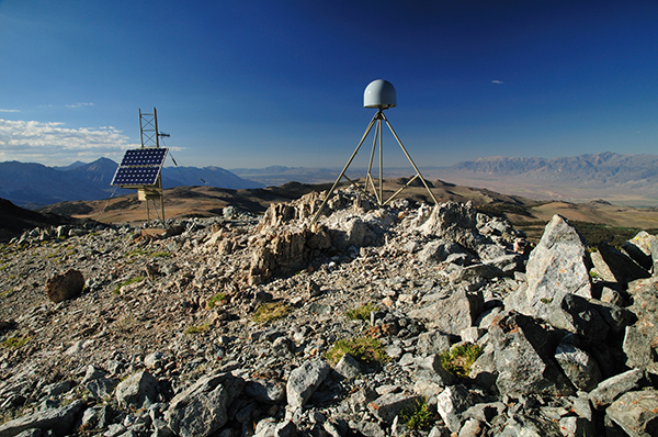
A study of more than 500 GPS stations in Southern California and Nevada found an anthropogenic signal in uplift of the Sierra Nevada and the California Coast Ranges related to long-term water withdrawal from aquifers in the San Joaquin Valley. Credit: UNAVCO
Humankind has proven time and again that it can reshape mountains, or even tear them down. Now, it appears, we can make them rise as well. Geologists studying growth rates of the Sierra Nevada and of central California’s Coast Ranges have identified an anthropogenic contribution to the mountains’ uplift that they suggest is tied to the decades-long depletion of groundwater in the state’s Central Valley. What’s more, the researchers report in a study published today in Nature, the long-term water loss may be affecting how stress builds up on faults like the San Andreas.
The scientists analyzed shifts in the vertical positions of more than 500 GPS sensors — spread across the Coast Ranges, the San Joaquin Valley (roughly the southern half of the Central Valley) and the Sierras — most of which have been recording data for at least four years (some have records extending back to the late 1990s). “We looked at two different [signals] in the GPS data: the long-term average vertical velocities and the seasonal patterns of ups and downs,” says Colin Amos, a geologist at Western Washington University and lead author of the new study.
Amos and his colleagues could see the “GPS stations rise and fall seasonally in relation to the hydrologic cycle,” recording the precise position of the ground surface below them, he says. Earth’s crust behaves elastically, so heavy snow and rainfall in winter and early spring push the mountains down, whereas during the summer and autumn dry season when the snowpack has melted, the mountains rise again. This seasonal trend is reversed in the valley: Recharge of groundwater, arriving as runoff from the mountains at the end of the wet season, swells aquifers and raises slightly the ground surface, which then sinks again as groundwater is removed and conditions become drier.
In addition to these seasonal variations — on the order of a centimeter up and down — the team found year-over-year trends in the stations’ average vertical positions. In the mountains around the edges of San Joaquin Valley, these trends showed elevation increases of roughly 1 to 3 millimeters annually, meaning the seasonal ups have been outpacing the downs, and that the mountains there are growing.
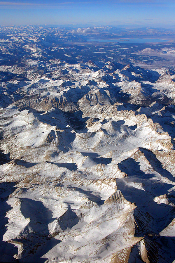
The Sierra Nevada in California. Credit: ©Jeffrey Pang, CC BY 2.0
“Hints of that [growth] signal have been seen before,” and various tectonic explanations have been proposed, Amos notes, particularly for the Sierra Nevada. For example, the mountains could be rising in response to the mantle slowly eating away at (or delaminating) the base of the crust beneath the Sierras, or due to continuing rebound after glaciers, which eroded huge masses of rock from the mountains thousands of years ago, melted. Both of these processes remove weight from the crust, allowing it to flex upward gradually over geologic time.
Rather than fall back on conventional tectonic hypotheses for their data, however, Amos and his colleagues modeled the elastic response of the crust in the area, accounting for the overall groundwater loss from aquifers beneath the Central Valley since pumping for irrigation and other uses began about 150 years ago. In that time, 160 cubic kilometers of water — more than enough to fill Lake Tahoe — is estimated to have been removed without replenishment, a whopping volume that has lightened the load considerably on the surrounding mountains.
Based on the team’s modeling, the response from the crust in Southern California that you’d expect from all that groundwater being lost “matches the GPS data really well,” Amos says. The results also agree with rates of unloading based on satellite data collected over the area in the 2000s by the orbiting Gravity Recovery and Climate Experiment, he and his colleagues reported. “It looks like the net vertical motion of the mountains upward can be explained just by humans sucking the water out of the ground,” Amos says.
Not only that, the team noted, but the flexing of the crust may induce stress changes on surrounding faults like the San Andreas. Detailed observations of the well-studied segment of the San Andreas Fault near Parkfield, Calif., have shown seasonal fluctuations in the frequency of small earthquakes that aren’t regularly felt but occur commonly. Such microseismicity is more common during the dry season when the central Coast Ranges are uplifting, suggesting the fault is “unclamping” slightly as the mountains rise both seasonally and over longer stretches, Amos says, which could impact future earthquakes on the fault.
To be clear, however, “this study does not imply that a large earthquake is imminent,” says Paul Lundgren, a geophysicist at NASA’s Jet Propulsion Laboratory in Pasadena, Calif., who wrote a commentary, also in Nature, on the new research.
Unclamping “would allow the fault to more freely slip,” which, in theory, should shorten the time between earthquakes, Lundgren says. If anything, he adds, this means that future quakes could be more frequent but smaller because the total amount of seismic energy released over long time periods shouldn’t be affected by human-induced effects. But so far, it’s unclear whether unclamping related to water withdrawal has had or will have significant impacts on San Andreas seismicity, he says. What the work highlights is that human interactions on Earth’s crust, “whether it’s water withdrawal or things like oil extraction … can potentially have some other unintentional effects,” a sentiment echoed by Amos.
“The link between groundwater depletion and seismicity may prove a little controversial,” says Steve Ingebritsen, a hydrogeologist with the U.S. Geological Survey in Menlo Park, Calif., who has studied hydrological effects on the San Andreas but was not involved in the new study. It’s “a really important and interesting suggestion” that “people will look at and try to evaluate independently,” he says, both in California and elsewhere around the planet where substantial groundwater unloading has occurred, perhaps, for example, in North India near Himalayan faults. As for the anthropogenic imprint on mountain building due to long-term water withdrawal in the Central Valley, Ingebritsen says he is “fairly convinced” the effect is real.
And given that “pretty much any projection for what climate is going to look like in California in the future involves an increasing need for groundwater,” Amos says “we can expect the phenomenon to continue.”
© 2008-2021. All rights reserved. Any copying, redistribution or retransmission of any of the contents of this service without the expressed written permission of the American Geosciences Institute is expressly prohibited. Click here for all copyright requests.