
by Sarah Derouin Friday, October 13, 2017
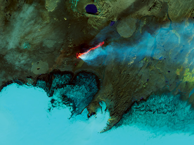
This false-color image of the 2014 Holuhraun eruption and lava field in Iceland was captured by the Landsat 8 satellite. Credit: NASA Earth Observatory/Jesse Allen.
If you live near a lava-spewing volcano, it could be helpful to know just how long molten rock might flow during a fiery eruption. In a new study, scientists report that they can calculate how long lava-flowing eruptions might last based on satellite data.
In 1981, Geoff Wadge hypothesized how effusive eruptions, like those on the Big Island of Hawaii or Iceland, progress: Once started, volcanic activity rapidly increases to its peak before slowing down gradually and eventually dying out. Plotting volcanic activity over time gives the time-averaged discharge rate, or TADR, for an eruption. If an eruption follows Wadge’s proposed pattern, the plot winds up looking something like a lopsided bell curve. The thought was that an effusive eruption would slow down in a progressive and predictable way, and therefore the TADR figures could be used to estimate the amount of time left in an eruption — important information in evaluating volcanic hazards and risk.
In the early 1980s, ways to test if effusive eruptions followed Wadge’s pattern were limited. “In Wadge’s 1981 work, volcanologists only had sparse field measurements for each eruption they studied,” says Estelle Bonny, a volcanology graduate student at the University of Hawaii at Manoa and lead author of the new study in the Bulletin of Volcanology. Now, however, satellites that scan Earth’s surface multiple times a day have greatly enhanced data collection. “During an eruption, we can [collect] a measurement up to four times a day, whereas [Wadge] had only a few data points for the entire eruption,” Bonny says.
Bonny and her co-author and advisor Robert Wright, also at the University of Hawaii at Manoa, analyzed thermal infrared remote sensing data collected over the past 15 years by the MODIS instruments aboard NASA’s Terra and Aqua satellites to study 104 effusive eruptions at 34 different volcanoes.
The infrared data allowed the researchers to detect and measure the amount of heat energy emitted by erupting volcanoes, Bonny says. From these measurements, the scientists could determine the volumes and flow rates of lava erupting over the course of each event they studied, which then allowed them to plot the TADR on the Wadge curve for each. The team found that the eruption behavior at 32 of the 34 volcanoes matched Wadge’s hypothesis, showing rapid increases in activity, followed by a long tailing off as flows subsided.
The authors found that the accuracy of predictions for the end of an effusive eruption increases with the number of data points collected during an eruption. Their best prediction of the end of an eruption was within one day of the actual end; their worst was off by 12 days.
The authors wrote that they originally hoped to create a global curve that would help predict end times for all effusive eruptions. But they found that each volcano — in fact each eruption — is unique, meaning a single, universal TADR curve is not possible. But, in general, as eruptions effuse, continual monitoring of the energy released can help pinpoint when lava will stop flowing, the researchers said.
Understanding how long lava-spewing volcanic eruptions might last is important to nearby communities. “There are plenty of places where the lava-flow hazards are real,” says Erik Klemetti, a volcanologist at Denison University in Ohio who was not involved in the study. Lava flows can cause expensive damage and can be disruptive to towns and residents living near volcanoes, he says.
Klemetti says that while the use of remote sensing satellites in monitoring and evaluating volcanic hazards is exciting, the “big caveat” in the new study is that the researchers were looking at “a very specific kind of eruption.” Unlike the effusive eruptions studied, explosive volcanic eruptions can be much more complex, with ever-changing conditions below the surface that are beyond the reach of remote sensing satellites.
But for people living in areas without volcano monitoring networks, remote sensing can help locals know what they might be in for during an eruption, Klemetti says. A technique “that can give even a ballpark idea of [determining] if the eruption is going to last a day or weeks is great for hazard planners.”
© 2008-2021. All rights reserved. Any copying, redistribution or retransmission of any of the contents of this service without the expressed written permission of the American Geosciences Institute is expressly prohibited. Click here for all copyright requests.