
by Erin Wayman Thursday, January 5, 2012
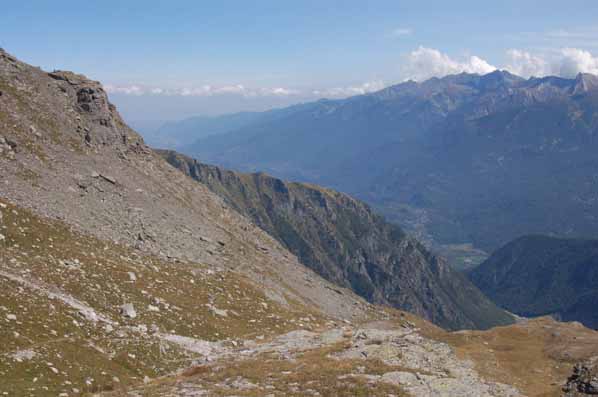
The Col du Clapier-Savine Coche with Turin (upper left) off in the distance. Edward Boenig, Creative Commons Attribution-ShareAlike 2.5 Generic
Standing at the summit of one of the Alps’ tallest mountain passes in the fall of 218 B.C., Hannibal peered into enemy territory: Italy’s Po River Valley. The panorama was reassuring. Hannibal’s plan — a sneak attack of the Romans on their own soil — was at last within reach. As his army trudged along a snow-covered path, Hannibal, Carthage’s greatest military leader, used the sight of Italy to encourage his ailing troops to keep going.
They needed the encouragement.
For about five months, the army, initially consisting of at least 25,000 foot soldiers, 12,000 cavalrymen, thousands of pack animals and 37 elephants, had marched through what is now Spain and France before ascending Europe’s greatest mountain range. In the Alps, the army had suffered attacks by mountain tribesmen, weakening the massive force. In addition to the unfriendly locals, the soldiers had to contend with the Alps’ high-altitude climate. Many of the soldiers, largely mercenaries from North Africa and Spain, had probably never seen snow before.
The soldiers who survived the steep descent into Italy helped Hannibal defeat the Romans in several key battles, and spent more than a decade in Italy engaging Roman forces. But the Romans were winning the war across the Mediterranean, so Hannibal eventually returned to Carthage. Hannibal’s military genius was not enough to save his homeland, however, and in 202 B.C., Carthage admitted defeat and gave Rome the victory to end the Second Punic War.
Despite Carthage’s defeat, historians have lauded Hannibal’s march through the Alps as one of the greatest tactical operations in military history. More than 2,000 years later, historians are still trying to figure out how the Carthaginian hero managed the feat; in particular, historians are still pondering the exact route Hannibal forged through the mountains.
Ancient Greek and Roman historians left clues to Hannibal’s route, but these texts lack the names of key landmarks along Hannibal’s journey. But where history has faltered, science may be able to fill in the gaps. Geoscientists are now lending their expertise in reading the terrain to match ancient descriptions of the landscape with their locations in the Alps. Science is indeed the best hope historians have of uncovering Hannibal’s alpine path, says Patrick Hunt, an archaeologist at Stanford University in California who has been studying Hannibal’s route since 1994.
Hunt is not alone in this pursuit. Bill Mahaney, a geologist and professor emeritus at York University in Toronto, Canada, has also been retracing Hannibal’s footsteps for the past decade. Hunt and Mahaney have come to vastly different conclusions on where Hannibal marched through the Alps, but they agree on one thing: The true test of their work will be the discovery of Punic burials, Carthaginian coins or some other artifact that could only have been left behind by Hannibal’s army on its way to Italy.
In 247 B.C., Hannibal was born in Carthage, a North African civilization in present-day Tunisia founded by Phoenicians more than 500 years earlier. Hannibal was born near the end of the First Punic War, in which Carthage lost its claims to Sardinia and Corsica to the rising Roman Republic. In the decades following those losses, Carthage expanded its empire into new territory: the Iberian Peninsula.
The Romans declared war on Carthage again in 218 B.C. By that time, Hannibal had become the commander of Carthage’s army in Spain. The Romans expected the war to be waged in Spain and North Africa, as historian John Prevas of Eckerd College in St. Petersburg, Fla., writes in his book “Hannibal Crosses the Alps,” so Hannibal concluded that the best way to overcome his enemy was to surprise them: March into Italy and attack the heart of the Roman Republic. In the early summer of 218 B.C., Hannibal assembled his army and left New Carthage (Cartagena) in southern Spain. Five months and 1,600 kilometers later, Hannibal made it to Turin, Italy.
Modern historians know the timeline and general trail of this march based on the writings of two ancient historians: Polybius, a Greek born in roughly 200 B.C., and Livy, a Roman born in 59 B.C. Hannibal researchers must place their complete faith in the work of these men because no other ancient texts regarding Hannibal’s march have survived. On details where Polybius and Livy differ, historians tend to defer to Polybius because he actually traveled through the alpine terrain that Hannibal covered, Hunt says.
The crucial part of Hannibal’s trip, in terms of unraveling where he crossed the Alps, begins after Hannibal crossed the Rhône River in southern France and started marching north. After following the Rhône for four days, the army arrived at what Polybius and Livy simply call the “island,” a low-lying parcel of land between the Rhône and a river that Polybius called “Iskaras” and Livy called “Arar.” For the next week and a half, Hannibal’s army followed the Iskaras/Arar into the mountains, covering approximately 180 kilometers.
By the time the army entered the most rugged part of the Alps, with elevations of nearly 4,000 meters, it was early fall, and the journey was not peaceful. Hannibal’s army thwarted one attack by a mountain tribe known as the Allobroges before falling victim to an ambush five days later. The ambush occurred in a narrow gorge bordered by a steep wall on one side and a river on the other. When the entire army entered the gorge, walking single-file along the precipitous path, tribesmen perched on cliffs above began their assault. The attack spooked the army’s horses and elephants and as many as 10,000 of Hannibal’s soldiers fell to their death amid the confusion, as the tribesmen hurled boulders and slung arrows at them. Part of Hannibal’s army spent the night at a nearby “bare rock” or “white rock” place, as Polybius described it, and was reunited with the remaining soldiers the next day.
The army then marched along the valley floor and began to climb a snow-covered pass. Hannibal made a base camp nearly 200 meters beneath the pass’ summit to allow his battered, hungry army to rest for two days. When the army arrived at the summit, the soldiers could see the plains of Italy stretched out below. On the steep climb down, the army encountered a rockfall that blocked their path. Hannibal ordered his engineers to rebuild the path, and according to Livy (but not mentioned by Polybius), the army attempted to clear a particularly large precipice by setting it on fire: Soldiers burned whatever wood they could find and hoped the heat would fracture the rock, making it easier to clear the path, so the story goes. The rockfall was the last great obstacle Hannibal and his men encountered on their journey down the mountain. They were at last in Italy.
Over the centuries, historians have used the topographical clues within this general description to narrow down the number of possible routes Hannibal took through the Alps. Two routes that run more or less parallel to each other before converging in Italy are most favored: a northern route and a southern route. Hunt prefers the northern route. In this scenario, Hannibal followed the Isère River north after leaving the island and later climbed the Col du Clapier-Savine Coche pass to get into Italy. Mahaney favors a route that starts a few kilometers south of where the Isère branches off the Rhône, where the Rhône meets the Drôme River. Along this southern route, he says, Hannibal followed the Drôme eastward into the mountains and later climbed over the Col de la Traversette into Italy.
Both Hunt and Mahaney have traversed these alpine routes several times, looking for clues related to Hannibal’s journey.
Mahaney has always had an interest in ancient history. About a decade ago, he started reading about the Second Punic War. When he discovered that one of the biggest unsolved questions in that war regarded Hannibal’s march, he realized he might be able to solve the mystery. “As I read through all of this material,” he says, “I discovered that I could put an environmental matrix together, a table that I could use as a checklist” to assess various routes and mountain passes as described by Polybius and Livy. He and his colleagues, including Pierre Tricart, a geologist at the University of Grenoble in France, have done just that in four alpine expeditions to find Hannibal’s trail over the past eight years.
Their work has found that the southern route — first advocated in the 1950s by Sir Gavin de Beer, a former director of the British Museum — best matches all of the variables on Mahaney’s checklist. For example, they have identified the 21-kilometer-long narrow canyon Combe de Queyras as the site of the second ambush attack. The gorge sits along the Guil River and is bordered by steep, 200-meter-tall walls with plenty of rocky debris that the mountain tribesmen could have used as deadly projectiles: quartzite, dolomite and ophiolites (bits of oceanic crust and mantle that were pushed up and over continental crust) such as serpentine and basalt. In contrast, potential ambush sites along the northern route don’t work, Mahaney says. They aren’t large enough to hold Hannibal’s army, Mahaney’s team explained in a 2010 article in the journal Archaeometry, and pollen analyses described in a second 2010 article in Archaeometry indicate the cliffs above would have been forested in 218 B.C., just as they are today, making it difficult for the tribesmen to pummel rocks and roll boulders at the Carthaginians below.
But in all of the work that Mahaney has done, he says the best lines of evidence in favor of a southern route — and in particular, the Col de la Traversette as Hannibal’s mountain pass — are permafrost and a two-tiered rockfall.
Polybius described how snow and ice made the climb down the mountain pass into Italy a dangerous, slippery descent. Soldiers’ feet sunk in a fresh layer of snow and then slid in layers of icy compacted snow from the previous winter, called firn. Climate studies show that the climate in the Alps at the time of Hannibal’s march was similar to the climate today, Mahaney says, so one way to test mountain passes along the proposed routes is to look for firn. It’s only present at one of the potential passes — Col de la Traversette — he says. At nearly 3,000 meters high, the Traversette has a microclimate that keeps snow from completely melting during the summer. If the Carthaginians were indeed sliding down the slopes of an alpine pass, then it must have been this one, Mahaney says.
In addition, the Traversette is home to a rockfall on its eastern side, at 2,600 meters above sea level, large enough to have blocked Hannibal’s army. In his writings, Polybius described the feature as a two-tiered rockfall, one rockfall event on top of an older one. Of all the mountain passes that Mahaney has investigated, only the Traversette has a two-tiered rockfall large enough to stop Hannibal’s army. “That’s the thing that really blew me away,” he says.
The rockfall consists of mica schist and metamorphosed basalt rubble of varying size, from pebbles to boulders, and likely originated from an outcrop 100 meters higher. Differential rates of weathering confirm that the rockfall does indeed consist of two separate events. The older rockfall likely dates to the Late Glacial, sometime between 12,000 and 10,000 years ago, while the younger rockfall dates to the Neoglacial, between 3,000 and 1,000 years ago, Mahaney and his colleagues reported in Archaeometry. One way the team estimated the younger dates was by analyzing the soil properties of the younger deposit — such as its color and particle size — and then matching the soil to dated alpine mountain soils with similar soil profiles. The work confirms both rockfalls were present at the time of Hannibal’s march. And with a volume of up to 75,000 cubic meters spread out across 250 meters, it definitely would have been a challenge to get around, Mahaney says.
The rockfall, however, shows no signs of being fired, as described by Livy. There is burned rock along the Col du Clapier, the mountain pass along the northern route that Hunt believes Hannibal used to get into Italy, but Mahaney is skeptical that the fire dates back to 2,000 years ago or that it was ignited by humans. It is also too small to have been a barrier to the army, he says.
Mahaney came to these conclusions using several lines of evidence. First, his team created a “geothermometer” using the results of Raman Spectroscopy done on carbon-bearing minerals in the fired rock from the Clapier to determine the fire must have reached temperatures between 330 and 650 degrees Celsius, they reported in Geoarchaeology in 2007. Those temperatures are on par with a brushfire, Mahaney says — a brushfire likely started by a lightning strike, although tests looking for evidence of lightning-induced magnetization of the rocks have been inconclusive, the team reported. Still, the fire probably only occurred 100 or 200 years ago, Mahaney says. A lack of weathering on the fired, carbonized crust of the rocks and a lack of lichen growth (which can be used as a relative measure of age because lichen grows at a regular, measurable pace) point to the young age. Attempts to radiocarbon date the fire failed because not enough carbon was recovered from the rocks' carbonized crust, Mahaney says.
These results, he says, indicate the fired rock does not support the case for a northern route. And the lack of fire at the Traversette doesn’t hurt the southern route’s case, he says, because the fire may never have happened, as Polybius, the more reliable Hannibal historian, never mentioned it.
Mahaney is still conducting various lab tests on samples from the Alps, but at this point, he’s confident that he has made a strong case for the southern route and the Traversette. In his 2009 book, “Hannibal’s Odyssey,” he lays out all of the environmental variables — the rockfall, the permafrost, the gorge as well as appropriate campsites that could have held Hannibal’s entire army — in favor of this route. “I think I’ve got it nailed down pretty exactly,” he says.
Hunt and his colleagues disagree with Mahaney’s assessment. The southern route isn’t the best fit with the historical evidence, Hunt says. British historian Frank William Walbank discredited the southern route in the 1950s, in part, on the grounds that it didn’t match up with Polybius’ description and timeline of events, he says.
Part of the problem comes down to historical linguistics. For example, “Iskaras,” the Greek name that Polybius gave to the river that Hannibal followed after the island, is philologically similar to Isère, bolstering the claim that the Isère is indeed the river that led the army into the Alps, Hunt says. The Isère also marks the historical boundary of the Allobroges’ territory. “That tribe doesn’t seem to have moved a whole lot in hundreds of years,” he says, and it’s most likely that they would have attacked Hannibal in their own territory — which does not encompass the southern route. Proponents of the southern route must create a “convoluted passage for Hannibal to get near Allobroges territory,” he says, making it a less logical path than the northern route.
Historical arguments aside, Hunt says the geology of the Alps also provides evidence in support of the northern route. For example, contrary to other claims, he says, there are several potential ambush sites along the northern route. “There’s a place called the Gateway to the Alps, just outside of Grenoble, where two great massifs squeeze the Isère River to its narrowest point,” he says. “There is a perfect ambush spot there.”
Another ambush spot, likely the site of the second attack, is the Bramans Gorge. Polybius says that this attack occurred near a “white rock” or “bare rock” place. Hunt believes this landmark corresponds to a massive, 600-meter-tall exfoliating anticline made of gypsum and dolomite, which rises up just east of the Bramans Gorge. The exfoliation — a type of weathering in which entire sheets of rock are stripped from a formation — has chipped away at this arch-shaped fold for thousands of years. “It stands out in this area as brilliant white,” Hunt says. “This [anticline] is so dramatic because it’s surrounded by a dark, large forest.” The site is about 20 kilometers from the summit of the Col du Clapier-Savine Coche mountain pass — which fits Polybius’ description that the ambush occurred within a day’s march from the summit of the mountain pass where Hannibal showed his soldiers Italy. The path up the mountain has a gradient of up to 15 percent, so traveling just 20 kilometers in one day seems reasonable, Hunt says.
The Col du Clapier-Savine Coche was probably snow-covered back in Hannibal’s day, Hunt says. At 2,475 meters tall, the mountain pass is often home to summer snow, but not always. For example, Hunt and his colleagues found snow there in August in 1996 and 2004 but not on a subsequent summer trip in 2006, Hunt wrote in his 2007 book “Alpine Archaeology.” His team has also studied the soil chemistry and postglacial weathering of moraines along the pass to date the long-term stability of the Savine Valley near the Col du Clapier-Savine Coche summit, which is big enough to have held Hannibal’s army when it rested before making its descent into Italy. According to Hunt, who has studied 25 alpine mountain passes in his quest to locate Hannibal’s route, there is not a similarly suitable valley beneath the Traversette. On the descent down the Col du Clapier-Savine Coche, there is also a two-tiered rockfall that geological weathering dates to more than a few thousands years ago, Hunt says.
These are just some of Hunt’s findings. He cannot discuss all of his work because his research is sponsored by the National Geographic Society’s Expedition Council, which has a media exclusive.
But Hunt can talk about the type of research his team is still pursuing. A lot of this work involves figuring out how much the landscape has changed since Hannibal’s time. For example, he’s studying how much soil accumulation has occurred in the past 2,000 years in some of Hannibal’s possible campsites. In general, he says, soil accumulates slowly at such high elevations, but it’s also dependent on factors like average temperature and the rock type. And soil accumulation has to be balanced by the rate of erosion. He’s also trying to assess which areas along the Col du Clapier-Savine Coche pass are the most geologically stable and which are most likely to experience rockfalls. Any rockfalls that have happened since Hannibal passed through could have deeply buried important archaeological remains, making more stable sections along the pass better places to search for artifacts.
Geology may hold the clues, but uncovering artifacts is the ultimate
goal of both researchers. Mahaney has identified several sites along the
Combe de Queyras and the Col de la Traversette that he suspects might be
good places to investigate with ground penetrating radar to locate
archaeological remains. He’s now looking for an archaeologist who would
be interested in collaborating with him on such a project.
Hunt has begun to do archaeological investigations along the northern
route. His team returned to the Alps (he cannot disclose the location)
last summer with permits that allowed them to excavate to certain
depths. “The depth is exactly what we want based on what we know of soil
development,” he says. If his results confirm the presence of Hannibal’s
army, the millennia-old question over Hannibal’s march might be put to
rest.
If he doesn’t find what he’s looking for, then Hunt and Mahaney will continue their search. “No one’s going to know [where Hannibal crossed the Alps] until there is a sufficient number of archaeological artifacts found,” Hunt says. “It’s all speculative until there’s archaeological confirmation.”
© 2008-2021. All rights reserved. Any copying, redistribution or retransmission of any of the contents of this service without the expressed written permission of the American Geosciences Institute is expressly prohibited. Click here for all copyright requests.