
by Mary Caperton Morton Thursday, April 21, 2016
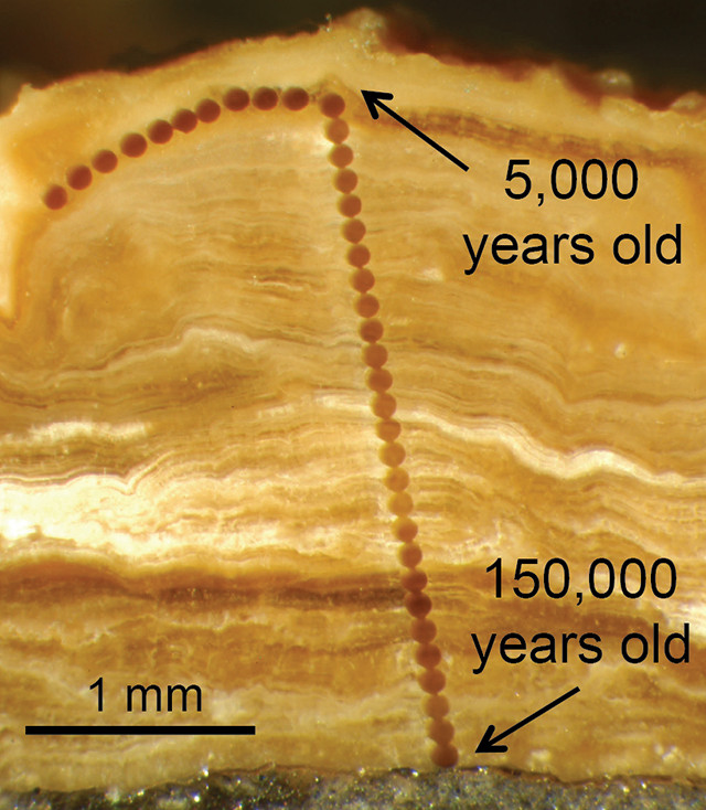
This cobble is coated with calcite layers that record 150,000 years of climate data. Credit: Warren Sharp and Erik Oerter.
Paleoclimate studies often depend on mineral or sediment layers deposited seasonally or annually in caves, lakes and ice, but such records leave gaps where caves, lakes or ice sheets aren’t found. Now, scientists using a new technique that analyzes calcite layers ringing pebbles and rocks in arid landscapes are opening a new window onto the climate history of western North America. And because such deposits are found all over the world, the technique might prove to be a useful new tool for studying paleoclimate globally.
When rainwater filters through the ground in arid regions, it dissolves calcium from soils, which can react with carbon dioxide to form the mineral calcite. This calcite precipitates on rocks ranging in size from pebbles to boulders, coating them with white growth-ring-like layers called pedothems.
“For decades, we wondered if these calcite deposits were forming laminar layers similar to stalactites in caves, but we didn’t have the technology to study such minute layers,” says Ronald Amundson, a soil scientist at the University of California at Berkeley and an author of the new study, published in Proceedings of the National Academy of Sciences.
In 2003, a team led by Amundson’s colleague and co-author on the new study, Warren Sharp of the Berkeley Geochronology Center, used dental drills to take minute samples from calcite layers on rocks gathered in Wyoming’s Wind River Basin. Sharp’s team showed that the pedothems, some as thin as 3 millimeters, indeed contained seasonal growth rings laid down over long periods of time; some deposit records spanned as long as 167,000 years.
The new study takes the technique a step further by using laser ablation and an ion microprobe to microscopically sample calcite from cobbles also gathered in the Wind River Basin. The researchers then measured the isotopic ratios of carbon, oxygen and uranium preserved in the samples. The uranium isotopes were used to date the deposits, while oxygen and carbon isotopes revealed clues about the precipitation, temperature and soil respiration at the time the calcite layers were formed.
The team studied rocks from a soil trench to get a better picture of soil conditions that reflect regional weather patterns, rather than just local conditions recorded by rocks at the surface, although rocks with pedothems “were found littering the ground, all over the place,” says lead author Erik Oerter, a geochemist at the University of Utah who coined the term “pedothem.”
“From just one rock we were able to get very precise and detailed records of climate that span more than 100,000 years,” Oerter says. The records preserved in the calcite layers from the Wind River Basin samples “match up beautifully” with climate records gleaned from the Devils Hole groundwater carbonate record in Death Valley, Calif., which is “considered the gold standard for long- term continental interior climate records” in North America, he says.
However, the Wind River pedothem and Devils Hole groundwater records differed during one span of time between 70,000 and 55,000 years ago. In this period, North America was experiencing widespread glaciation, with continental ice sheets expanding over eastern Canada. The oxygen and carbon isotopes indicate that Wyoming was experiencing warmer, wetter summers than California at the time, possibly reflecting ice sheet-induced shifts in atmospheric circulation that swapped the typical west-to-east flow of weather from the Pacific with a south-to-north flow that brought warm, moist air up from the Gulf of Mexico to central North America, Amundson says.
“It makes sense that Wyoming would have experienced different precipitation patterns than Death Valley because they are located on different sides of the Rocky Mountains, which present a barrier to atmospheric circulation,” he says. This change is corroborated by paleoclimate records preserved in cave deposits in South Dakota and Missouri, which overlap with the pedothem record and hint at wetter climates in central North America during this time period.
Now that the team has shown that the technique works, they hope it will be put to use in other regions of the world where cave, lake and ice paleoclimate records are poor or nonexistent, such as Chile’s Atacama Desert. “Carbonate deposits are ubiquitous in drylands all over the world,” says Aaron Putnam, a glacial geologist at the University of Maine who was not involved in the new study. “The approach this team has pioneered could open up a whole new window to studying paleoclimate.”
© 2008-2021. All rights reserved. Any copying, redistribution or retransmission of any of the contents of this service without the expressed written permission of the American Geosciences Institute is expressly prohibited. Click here for all copyright requests.