
by Terri Cook Friday, April 3, 2015
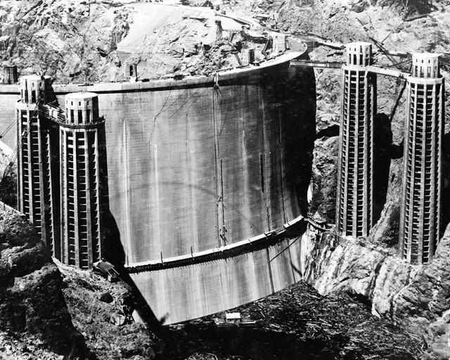
A number of earthquakes occurred during the 1930s while Lake Mead was being impounded behind Hoover Dam (shown here in May 1935), including a magnitude-5 event in 1939. Filling reservoirs is one of the ways humans can trigger earthquakes. Credit: U.S. Bureau of Reclamation.awes
In the pre-dawn hours of Aug. 6, 2007, six miners were laboring 450 meters underground, excavating coal from the Crandall Canyon Mine in the mountainous terrain of central Utah’s Wasatch Plateau. Suddenly, pillars supporting the mine roof ruptured, causing a major collapse over an area of 200,000 square meters and trapping the men underground.
Rescue teams were quickly dispatched to the site. For three days, they drilled a narrow borehole through the rock to the miners’ presumed location, but this and six subsequent holes failed to locate the miners. After four weeks of failed efforts — and the deaths of three rescuers in a second collapse on Aug. 16 — the search was reluctantly called off and the mine was sealed, entombing the bodies.
Following the initial collapse, Robert Murray, chairman, president and CEO of Murray Energy Corporation, which co-owned the mine, declared that an earthquake had triggered the disaster. However, detailed analyses by seismologists and a mining engineer from the University of Utah — published in Seismological Research Letters in 2008 — later concluded that the earthquake, which the local seismic network registered as a magnitude-3.9 event, had been triggered by the mine collapse — not the other way around. In July 2008, the U.S. Department of Labor’s Mine Safety and Health Administration fined Murray Energy $1.639 million for safety violations that had directly contributed to the nine deaths. The penalties were later reduced to $949,351 in a 2012 settlement.
In 2007, the collapse of the Crandall Canyon coal mine (above) triggered a magnitude-3.9 earthquake and killed six miners and three rescuers. Credit: Terri Cook and Lon Abbott.
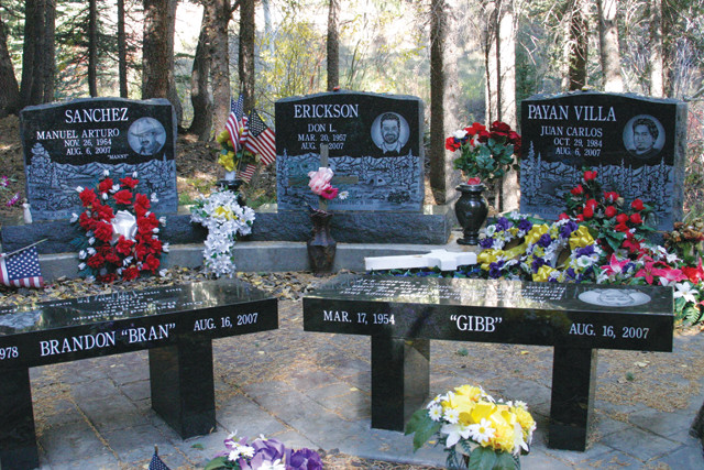
The six miners and three rescuers that were killed in the magnitude-3.9 earthquake due to the collapse of the Crandall Coal mine, are now memorialized at the site. Credit: Terri Cook and Lon Abbott.
The seismicity triggered by the collapse of the Crandall Canyon Mine was hardly an unusual event. Mining-induced seismicity (MIS) occurs frequently in the state’s central-eastern coalfields, where University of Utah seismograph stations detected more than 17,000 events between 1978 and August 2007.
The vast majority of these earthquakes, which did not result in fatalities, were caused by various forms of collapse associated with the redistribution of subsurface stress related to mining activities, according to Kris Pankow, associate director of the University of Utah seismograph stations and co-author of the 2008 report. The abrupt release of elastic strain in the rocks during a mine collapse discharges energy in the form of seismic waves. The primary source of the seismicity at the Crandall Canyon Mine was the implosion of the rock, Pankow says.
Less than 2 percent of Utah’s coalfield tremors are naturally occurring tectonic earthquakes, according to the same 2008 report, which was led by James Pechmann, a research associate professor at the University of Utah’s Department of Geology and Geophysics. In fact, mining-induced earthquakes are so common that they have found their way into the mining vernacular as “bumps” and “bounces.”
Most of these bumps are small — below magnitude 3 — capable of shaking indoor objects but very rarely causing any structural damage. However, in central Utah, several larger earthquakes associated with mine collapse have been reported, including two magnitude-3.8 events, in May 1981 and February 1998, and a magnitude-4.2 earthquake in March 2000.
Larger seismic events have been generated by mine collapses elsewhere, including a magnitude-5.2 shock from the 1995 collapse of a 1-by-2-kilometer section of a trona mine in southwestern Wyoming, and a magnitude-5.6 event produced by the collapse of a 6-square-kilometer section of a German potash mine in 1989.
MIS is not limited to collapse associated with the room-and-pillar or longwall methods commonly used to remove coal in central Utah. Seismicity has also been associated with open-pit mining, quarrying, and the flooding of inactive mines that had been kept artificially dry via pumping during mining operations.
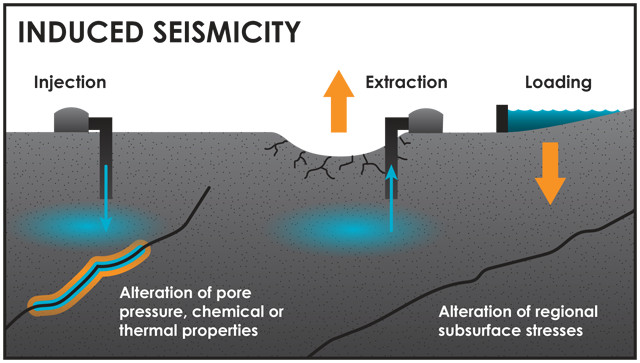
In addition to mine collapse, several other human-aided mechanisms can also induce seismicity, including elevated pore pressures and/or thermal and chemical changes due to fluid injection and subsequent migration; increased loading during reservoir impoundment; and alteration of subsurface stresses during the extraction of fluids like groundwater or hydrocarbons at a rate that causes subsidence and/or slippage. Credit: K. Cantner, AGI, after Ellsworth et al., Science, 2013.
We have known for more than a century that humans can induce seismicity. The first studies of this phenomenon began after a series of earthquakes in 1894 near Johannesburg, South Africa, were attributed to gold production in the nearby Witwatersrand fields, Arthur McGarr, a seismologist with the U.S. Geological Survey’s (USGS) Earthquake Science Center, wrote in the International Handbook of Earthquake and Engineering Seismology.
Around that same time, Europeans also began to recognize that mining could induce seismicity. In 1908, the first observatory for monitoring MIS was established in Germany’s Ruhr coal basin, and the first seismic network was installed in Poland’s Upper Silesia coal basin in the late 1920s.
Since that time, scientists have recognized additional types of human-induced seismicity, including earthquakes associated with petroleum production (1920s), reservoir impoundment (1930s) and injection wells (1960s).
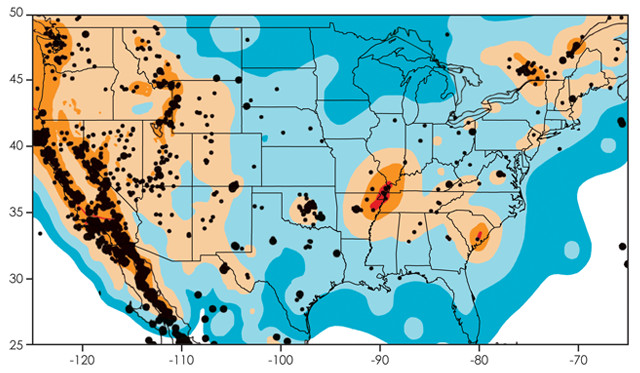
Seismicity in the U.S. from 2009 to 2012. Black dots are earthquakes with a magnitude greater than or equal to 3; larger dots denote events with magnitudes greater than or equal to 4. Background colors indicate earthquake hazard levels from the U.S. National Seismic Hazard Map. Credit: USGS.
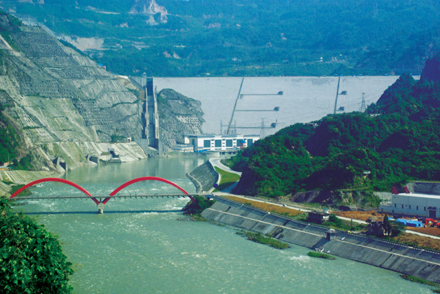
Impoundment of the Zipingpu reservoir in China in 2005 may have accelerated the 2008 Wenchuan earthquake. Credit: ©AlexHe34, CC BY-SA 3.0.
Reservoir-induced seismicity (RIS) is the most complex of these triggering mechanisms, which makes it difficult to predict the potential danger posed by building dams. The difficulty is partly due to scale — most reservoirs cover a large area and impound an enormous mass of water. For example, Lake Mead, which today is filled only to 41-percent capacity, stores 13.3 cubic kilometers of water, weighing 12.7 billion metric tons. But the potential for seismicity also depends on differences in the underlying geology and fault structure, according to a 2002 study by McGarr and colleagues.
RIS can be divided into two types: that caused by rapid stress changes caused by the weight of the water, and a more delayed response related to the diffusion of elevated pore pressure. Both can substantially alter local stress regimes — and cause earthquakes, as scientists observed in the 1930s while Lake Mead was filling. The largest tremor, a magnitude-5 event, occurred in 1939 when the lake was 80-percent full, according to a 1972 report by the National Research Council. But the earthquakes aren’t limited to the initial impoundment; in 2011, a couple of dozen small tremors ranging from magnitude 1.5 to 2.2 occurred as Lake Mead’s water level rose following the runoff of a record snowpack in the Rockies.
One widely accepted example of RIS that illustrates its destructive potential is the 1967 magnitude-6.3 earthquake in Koyna, India, which killed 177 people, injured more than 2,000, and left 50,000 people homeless. “Koyna continues to be the most significant site of artificial-water-reservoir-triggered earthquakes,” wrote Harsh Gupta, a fellow at India’s National Geophysical Research Institute, in a 2002 article in Earth-Science Reviews. In the 1990s, the area experienced two events exceeding magnitude 5 and several smaller events. The pattern exhibited in Koyna, of a mainshock followed by persistent seismic activity in an area with little natural seismicity — in this case lasting more than 30 years — doesn’t fit the usual pattern for tectonic earthquakes.
However, establishing a causal connection between reservoir impoundment and an earthquake can be extremely difficult, particularly in seismically active areas, as in the case of the 2008 magnitude-7.9 earthquake in Wenchuan, China, which killed nearly 90,000 people. Some researchers believe this earthquake was triggered by the Zipingpu reservoir, which began filling in 2005 and lies about 20 kilometers from the epicenter.
In a 2009 modeling study in Geophysical Research Letters, Shemin Ge, a hydrogeologist at the University of Colorado at Boulder, and co-authors concluded that the reservoir impoundment could have increased the stress on the hypocenter to a level shown to have triggered earthquakes on other critically stressed faults.
Xinglin Lei, a geophysicist at the Geological Survey of Japan, reached the same conclusion using a different numerical model in a 2011 study published in the Journal of Asian Earth Sciences. Both studies agreed that the Zipingpu reservoir impoundment could have hastened the earthquake’s occurrence by tens to hundreds of years.
These results, however, disagree with a 2010 Bulletin of the Seismological Society of America (BSSA) study led by Kai Deng, a scientist at Peking University’s School of Earth and Space Science. This study concluded that the Wenchuan earthquake was not induced by reservoir filling because the impoundment could only result in an increase in the rate of earthquakes at depths of less than 5 kilometers. Meanwhile, the exact depth of the hypocenter is still being debated, with estimates ranging from 6 to 19 kilometers. However, Ge contended in a 2011 BSSA comment that Deng and co-authors had omitted a crucial parameter in their calculation of pore pressure.
This debate is particularly relevant for countries like China and India that are building large new reservoirs to expand their power-generating capacities, Ge says. Whereas the U.S. is no longer constructing such reservoirs, China is preparing to build dozens of new dams on the Yangtze River alone. Because the effects of the resulting “stairstep” series of reservoirs may be cumulative, as well as interactive, Ge says, the potential hazards need to be rigorously assessed. “In terms of the basic science, we know how pore pressure will propagate from one place to another. But the million-dollar question is, ‘Do we know where the faults are?’” she asks.
It has become clear that filling large reservoirs in tectonically active areas carries a substantial risk of inducing damaging earthquakes, Ge says, and managing the risk related to RIS is difficult. “It’s much harder than for injection,” she adds.
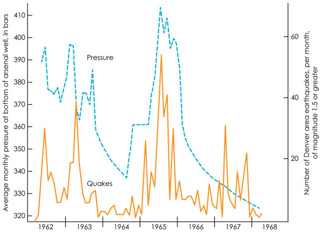
Some of the first data showing the relationship between wastewater injection and triggered seismicity was gathered at Rocky Mountain Arsenal near Denver, Colo., in the 1960s. Credit: K. Cantner, after Evans, The Mountain Geologist, v.3, 1966.
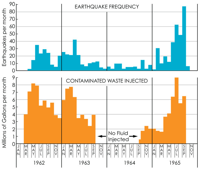
That humans can induce seismicity by fluid injection was first recognized near Denver, Colo., in the 1960s, at the federal chemical weapons manufacturing facility known as the Rocky Mountain Arsenal. Faced with the difficult problem of disposing of the arsenal’s chemical waste, the U.S. Army drilled a deep disposal well through more than 3,600 meters of sedimentary rock into the underlying Precambrian crystalline basement rock. Through this well, they began routinely injecting waste fluid under high pressure in March 1962.
Less than seven weeks later, earthquakes were reported in the Denver area, a region that had last felt an earthquake in 1882. Although the Army initially denied any link, when consulting geologist David Evans demonstrated a strong correlation between the Arsenal’s average injection rate and the frequency of earthquakes, the Army agreed to halt its activities. The largest Arsenal-related earthquakes, three tremors between magnitudes 5 and 5.5 that caused minor structural damage around Denver, all occurred in 1967, more than a year after injection had ceased, according to a 1968 study in Science led by USGS scientist J.H. Healy.
Hydrologic modeling and other studies later revealed that earthquakes like those at the Rocky Mountain Arsenal occur when injection increases the fluid pressure in the pores and fractures within rocks or soil, which can weaken preexisting faults by reducing the frictional force that resists fault slip. If the increase in pore pressure exceeds the level of ambient stress on a fault, it can trigger movement along the fault, resulting in an earthquake. The delay between the end of injection and the onset of seismicity can be due to many factors, including diffusion rates, the porosity and permeability of the faulted bedrock, the volume and rate of fluid injection, and the presence or absence of hydraulic connections to faults.
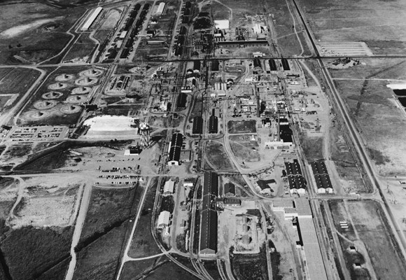
In the 1960s, a deep injection well at the Rocky Mountain Arsenal in Colorado triggered earthquakes in nearby Denver. The site of the former chemical weapons facility is now a wildlife refuge. Credit: Library of Congress.
Although the Rocky Mountain Arsenal earthquakes initially struck near the bottom of the disposal well, over the course of five years the seismicity gradually radiated outward up to 7 kilometers from the injection point, even after injection had ceased. This pattern demonstrated that the diffusion of elevated pore pressure can initiate earthquakes far from the point of injection, up to months or years later, particularly if there is a hydraulic connection between the injection zone and basement faults, reported William Ellsworth, a researcher at the USGS Earthquake Science Center in Menlo Park, Calif., in a 2013 Science study.
With the insights gained at Rocky Mountain Arsenal in the mid-1960s, scientists began wondering whether humans could actually control earthquakes by modulating a fault’s fluid pressure. To test this hypothesis, the USGS began an experiment in northwestern Colorado’s Rangely oilfield in 1969, where water was being injected under high pressure to enhance oil recovery and had produced low-magnitude (in this case, less than or equal to magnitude-3.4) earthquakes.
Based upon laboratory measurements of core samples as well as in situ stress-field measurements, the USGS scientists determined that the pressure of the formation receiving the injections in the Rangely oilfield was about 17 megapascals, and they predicted that a critical fluid pressure of 26 megapascals would be required to induce earthquakes. Over the next four years, multiple cycles of fluid injection and withdrawal were monitored. The USGS scientists found that when the pressure in a monitoring well exceeded the critical value of 26 megapascals, earthquake activity increased; when pressure dropped below the threshold, it quickly decreased, sometimes within a day. This provided “strong evidence that the rate of seismicity could be controlled by adjusting the pore pressure at the depth where earthquakes initiate, if stress conditions and the strength of the faulted rock mass were known,” Ellsworth wrote in Science in 2013.
Fluid injection increases pore pressure, which can weaken preexisting faults by reducing the frictional force that resists fault slip, thus triggering quakes. Credit: K. Cantner, after Evans, The Mountain Geologist, v.3, 1966.
Regardless of the exact mechanism that triggers it, each human-induced tremor poses a potential hazard. In general, the hazard associated with an earthquake — natural or induced — depends upon several factors, including the magnitude (the amount of energy released), the recurrence frequency, and the proximity of a tremor to populous areas or critical infrastructure.
These factors are incorporated by USGS into the National Seismic Hazard maps, which show long-term (50-year) potentials for severe ground shaking and which are used in setting everything from building codes to insurance rates. When these maps were revised in July 2014, the USGS intentionally left out the contribution from induced earthquakes despite the fact that large areas of the midcontinent that were previously considered geologically stable have recently become seismically active. In Oklahoma, for example, seismicity between 2008 and 2013 increased 40-fold compared to the period from 1976 to 2007, according to a 2014 Science study led by Cornell geophysicist Katie Keranen.
“Seismic swarms within Oklahoma dominate the recent seismicity in the central and eastern United States, contributing 45 percent of magnitude-3 and larger earthquakes between 2008 and 2013,” Keranen and colleagues wrote. “No other state contributed more than 11 percent.”
This increase in seismic activity has been caused in part by the rise in the number of waste-fluid injection wells — now totaling about 140,000 in the U.S. — that has accompanied the use of hydraulic fracturing for energy production. The process, also called “fracking,” entails the injection of fluids underground at sufficient pressures to fracture the surrounding rock, forming cracks through which previously rockbound hydrocarbons can flow. However, the amount of wastewater resulting directly from the fracking process makes up only a small percentage of what goes into disposal wells; the far larger contribution is saline water that is produced along with the oil or gas.
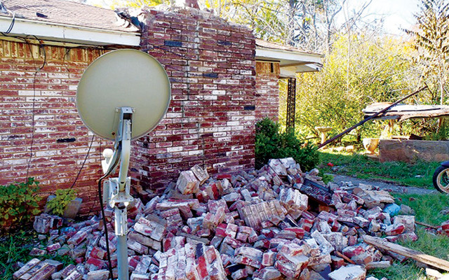
House damage in central Oklahoma from the magnitude- 5.7 earthquake on Nov. 6, 2011, which may have been induced by injection into underground disposal wells. Credit: Brian Sherrod, USGS.
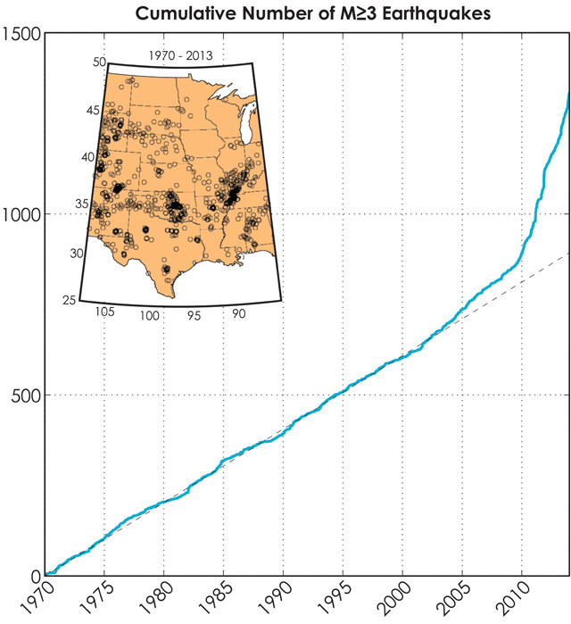
Cumulative count of earthquakes with a magnitude greater than or equal to 3 in the central and eastern United States between 1970 and 2013. The dashed line corresponds to a long-term rate of 20.2 earthquakes per year. Credit: USGS.
“Although only a small fraction of disposal wells have been associated with induced earthquakes large enough to be felt, there are so many disposal wells that this contributes significantly to the total seismic hazard, at least in the midcontinent,” wrote McGarr and colleagues in Science in February of this year.
So why has induced seismicity been excluded from these hazard maps? The answer stems from the inherent differences between natural and induced seismicity. In terms of hazard assessment, natural seismicity is usually assumed to be independent of time, whereas seismicity induced by fluid injection is typically time-dependent. Unlike natural earthquakes, injection wells can be turned on and off and thus do not present a consistent hazard. Variations in human-induced seismicity are due to changes in the rate and location of injections, as hydrocarbon production decreases in some areas and increases in others. Thus, hazards from natural and induced earthquakes can’t be easily combined. The USGS is currently developing a separate hazard model for induced seismicity.
This separation of hazard assessments necessitates determining whether earthquakes, or earthquake sequences, were natural or induced, particularly in areas with human activities known to cause quakes. But such determinations are not always straightforward, partly because both types of earthquakes appear similar on seismograms. Ultimately, if an earthquake sequence correlates in timing and location with injection activity, like in the case of the Rocky Mountain Arsenal, then the earthquakes were likely induced, particularly if they occurred in an area with little or no previous seismic activity.
If, however, there is a delay between the start of injection and the onset of seismicity, or a discrepancy of many kilometers between the injection site and the earthquake, or a record of natural background seismicity in the area, then experts may not agree upon, or be able to assess, the potential hazard for a given earthquake. For example, there is considerable agreement that the magnitude-4 earthquake that shook Youngstown, Ohio, on New Year’s Eve 2011, was induced by wastewater injection. However, the causes of both the magnitude-5.7 earthquake that struck near Prague, Okla., on Nov. 6, 2011, and the magnitude-4.9 event that shook eastern Texas on May 17, 2012, are still being debated, even though both occurred near active wastewater injection wells.
Furthermore, a March 2014 study led by Danielle Sumy, a visiting scientist at the USGS Earthquake Science Center, suggests that an injection-induced magnitude-5 earthquake that occurred less than a day before the magnitude-5.7 event in Prague, Okla., may have triggered a cascading series of earthquakes along the local Wilzetta fault system, including the mainshock that damaged 14 homes and injured two people.
Although most researchers agree that the magnitudes of the largest injection-induced earthquakes correlate with the volume of fluid injected, there is still debate about whether the key factor controlling the maximum magnitude is the total volume injected, the rate of injection, or the size of a nearby fault and its relationship to the current stress state, as is the case for natural seismicity.
Of the roughly 140,000 injection wells in the U.S., only 40,000 are waste-fluid disposal wells for oil and gas operations — and only a small fraction of those have induced earthquakes large enough to be of concern to the public. Credit: William Ellsworth, USGS.
In the U.S., the safety and the legal implications of human-induced seismicity are largely focused on earthquakes caused by fluid injection, which is often associated with hydraulic fracturing.
However, fracking itself has triggered only a few earthquakes large enough to be felt; the greater hazard stems from the underground injection of the wastewater generated by the process. “It’s important to clear up some misconceptions,” Ge says. “It is the wastewater injection that creates the majority of felt earthquakes.”
The amount of this waste has grown as the U.S. shale gas industry has rapidly expanded. In Texas alone, the volume of wastewater disposed in injection wells increased from 46 million barrels in 2005 to almost 3.5 billion baccording to data released by the Railroad Commission of Texas.
The current regulatory framework for wastewater disposal wells was designed to protect sources of potable water, not to address seismic safety, and in most caseg authority has been delegated to state agencies. A common approach by these agencies for mitigating the risk has been to im light" systems. Under a green light, fluid injection can proceed normally, but if induced earthquakes begin to occur, the light changes to yellow, at which point the operator must reduce the volume and/or rate of injection to avoid triggering larger tremors. If the earthquakes become large enough, the light turns red, and further injection is prohibited. One such system was enacted near Greeley, Colo., last year after a magnitude-3.4 event occurred near an injection well there.
Traffic light systems are most effective early in the injection process, according to Ge, because the ability to control the seismic hazard decreases over time as pore-pressure effects propagate away from a well. In addition, these systems depend upon the ability of seismic monitoring networks to detect very small earthquakes that can precede larger seismic events. Yet the current detection threshold across much of the U.S. is magnitude 3. To identify hazards while there is still enough time to undertake effective mitigation, McGarr and his colleagues recommended in their 2015 study monitoring events of magnitude 2 or less, which is not currently possible in many of the midcontinent areas where seismic activity has dramatically increased.
South-central Kansas is one of these areas, and because it was relatively aseismic, the state was under-instrumented when seismicity began to increase, says Rex Buchanan, interim director of the Kansas Geological Survey. In response to increased concern about induced earthquakes, the survey is in the process of deploying a temporary seismic array in the south-central portion of the state where they’re seeing a lot of seismic activity, Buchanan says.
In Oklahoma, the state geological survey increased its monitoring network beginning in 2008, says Randy Keller, who retired in December after serving as the director of the Oklahoma Geological Survey (OGS) for seven years. “Our first response was to hire another seismologist,” Keller says. They also beefed up their instrument network, and at this point, the OGS network “would certainly detect a magnitude 2.5 anywhere in the state,” he says. The OGS is also conducting detailed studies of selected earthquakes like the Prague event and compiling a digital dataset of fault locations that’s already being used to help make decisions about injection-well permitting, Keller says.
In both Kansas and Oklahoma, the geological surveys serve in an advisory capacity to the regulatory agencies that oversee oil and natural gas exploration and production and make the well-permitting decisions. Buchanan is also regularly called to testify at legislative hearings and is chairing a governor-appointed task force charged with developing an action plan for potential induced seismicity in the state.
The issue of induced seismicity has had “an incredible impact” on what the survey does, according to Buchanan, who estimates that he spends about 90 percent of his time dealing with the issue. “Having said that, I think we’re responding to it appropriately,” he says. “We’re concerned about residents and buildings and everything else that goes along with increased seismic activity,” Buchanan says. “The first thing I do every morning is check for earthquake alerts.”
© 2008-2021. All rights reserved. Any copying, redistribution or retransmission of any of the contents of this service without the expressed written permission of the American Geosciences Institute is expressly prohibited. Click here for all copyright requests.