
by Mary Caperton Morton Monday, June 1, 2015
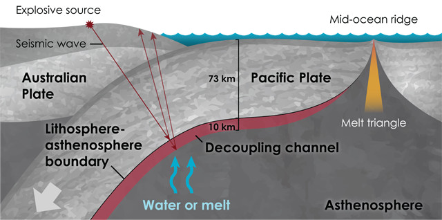
New Zealand provides an ideal location for imaging the base of the Pacific Plate as it dives under the southern tip of the country's North Island, which lies on the Australian Plate. Credit: K. Cantner, AGI, after C.A. Rychert, Nature, 2015.
Earth’s rigid, brittle lithosphere is broken into seven major plates, as well as many minor plates, which ride along atop a ductile layer of the upper mantle called the asthenosphere. For all we know about Earth’s cracked outer shell, however, a clear picture of the lithosphere-asthenosphere boundary at the bottom of the plates has proved elusive. Now, new research using explosives to image the oceanic plate dipping beneath New Zealand’s North Island is helping to blast away some of the uncertainty about this boundary by giving scientists a sharper look at a piece of the planet’s tectonic underbelly.
Traditionally, the depth and thickness of the lithosphere-asthenosphere boundary were thought to be governed by temperature, which strongly influences the viscosity of rocks and their ability to flow. However, as seismic imaging capabilities have improved, the temperature model has fallen out of favor. “If temperature were the sole dividing factor, then the transition between the lithosphere and asthenosphere would likely be gradual” because temperature gradients tend to be smoothed out by heat diffusion in rock, says Tim Stern, a geophysicist at Victoria University of Wellington in New Zealand and lead author of the new study in Nature. But, Stern says, “seismic imaging studies seem to indicate that the boundary is sharp,” suggesting that other factors may influence this layer as well.
Seismic imaging of tectonic plates is usually accomplished by eavesdropping on seismic waves produced by earthquakes. Stern and colleagues instead used seismicity from controlled explosions, which offer much higher-resolution pictures because they can be detonated near features of interest. “This technique is commonly used by the oil industry to image the top 3 to 5 kilometers of Earth. We adapted the method to [look] much deeper, down to around 100 kilometers,” Stern says.
After installing a network of 877 seismometers around the southern tip of New Zealand’s North Island, Stern’s team set off dynamite charges in a series of 50-meter-deep boreholes drilled into the surface of the Australian Plate above the down-going Pacific Plate. The researchers then analyzed the behavior of the blast-generated seismic waves, which reflected off various subsurface layers before being picked up by the seismometers.
With the data, the scientists generated the highest resolution images ever captured of the base of the Pacific Plate. They found that the Pacific Plate beneath the North Island is 73 kilometers thick, with a 1-kilometer-thick lithosphere-asthenosphere boundary at its base. Below that is a distinct, 10-kilometer-thick channel in which seismic wave speeds were observed to slow substantially compared to speeds in the rock above and below this layer.
Previous studies estimated the lithosphere-asthenosphere boundary region to be as thick as 20 kilometers or as thin as five, but in the past, resolutions were too low to pinpoint where the lithosphere ended and the asthenosphere began. “This team was able to put some really tight constraints on the lithosphere-asthenosphere boundary, in terms of the sharpness of the base of the tectonic plate,” says Catherine Rychert, a geophysicist at the University of Southampton in England, who wrote a commentary on the new study in the same issue of Nature. And the 10-kilometer layer beneath the boundary “has not been imaged this clearly before,” she adds.
The sharp boundary suggests that something other than temperature change defines the position of the bottom of the plate. Given the decreased seismic velocities in the channel below it, Stern and his colleagues proposed that this layer has relatively low viscosity and may be rich in water or magma, perhaps accumulating the small portion of rock that naturally melts out of the otherwise solid asthenosphere.
“These melts rise gravitationally and pond at the bottom of the lithosphere,” Stern says. “The more fluid that collects, the weaker the boundary zone gets, which facilitates movement between the bottom of the plate and the underlying asthenosphere,” he says, similar to how fluids can collect in and lubricate a fault zone. In other words, this low-viscosity channel appears to decouple the overlying plate from the mantle, allowing plate motion to progress.
The new results seem to agree with previous studies from Norway and Japan, which also indicated a sharp lithosphere-asthenosphere boundary and an underlying decoupling channel, suggesting that these may be characteristics of all tectonic plates. But, Stern says, this earlier work was done using earthquakes and seismic waves generated by air guns, which offer lower-resolution images. More work using explosives is needed to further clarify the picture of the lithosphere-asthenosphere boundary globally, he says, though he acknowledges that it’s a more time-consuming, expensive and environmentally problematic technique than others.
“It’s important to understand all kinds of tectonic environments,” Rychert says, “so we can really get to the bottom of what defines this boundary.”
© 2008-2021. All rights reserved. Any copying, redistribution or retransmission of any of the contents of this service without the expressed written permission of the American Geosciences Institute is expressly prohibited. Click here for all copyright requests.