
by Lucas Joel Thursday, November 8, 2018
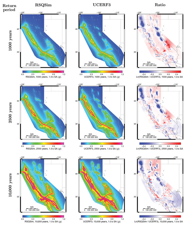
This figure shows the likelihood of earthquake occurrences in California over different timescales using a new physics-based model (left column) and the UCERF3 hazard model (middle column). The right column shows the ratio between the results of the two models. Credit: Shaw et al., Science Advances, August 2018, CC BY-NC 4.0.
In California, scientists use a model called the Uniform California Earthquake Rupture Forecast (UCERF3) to assess earthquake hazards across the state based not on the physics of the state’s faults, but on history: By considering the historic record of earthquakes, including the location and severity of past quakes, UCERF3, the third version of the model, provides a hazard measure. “But those observations are limited, because we only have a few hundred years [of written earthquake records] in California,” says Greg Beroza, a seismologist at Stanford University. “In the long term, we have a small sample of the possible behavior of the system.” This means the resulting hazard assessments, relying on the relatively short historical earthquake record, may not accurately reflect earthquake potential across the state. So, scientists have long been trying to come up with physics-based models that show how particular faults might rupture without depending on historical records — and now, they have.
The aim of decades of work has been to forecast earthquake hazard — or the likelihood that an earthquake of a particular size will strike a particular area, says Bruce Shaw, a geophysicist at Columbia University’s Lamont-Doherty Earth Observatory. Shaw led the team that developed the new model, which was described in a new study published in Science Advances. “Can we simulate our understanding of earthquakes on a computer, and does it look like the way [real] earthquakes look?”
Mimicking earthquakes on a computer is tricky because faults can have complex surfaces and orientations that make it unclear how they would slip during an actual quake. But by incorporating a previously designed earthquake simulator called RSQSim, the team developed one of the first models that can handle such complexities and incorporate them into its forecasts. RSQSim “can handle most of what you throw at it,” Shaw says. This includes accounting for the complex geometries that fault planes can have, and the unique physical states of faults — for instance, how much stress a particular fault is likely under. What that simulator does not do, though, is forecast the likelihood of an earthquake happening in the future along a particular fault or series of faults, which is where the new modeling work comes in.
Interestingly, Shaw says, his team’s model results and the results of UCERF3 — both of which forecast the earthquake likelihoods across California — closely match the results of UCERF3. Coming up with the same answer from very different methods “makes you think, ‘Wow, we’re not doing so bad,’” he says.
Because the new model accounts for the physical nature of California’s faults, it can help seismologists gauge how an earthquake on the San Andreas Fault could influence the probability of an earthquake on the Hayward Fault, says Beroza, who wasn’t involved in the new study. “Previous ways of doing this modeling have not captured that [interconnectivity],” he says. “I think this is going to be a landmark paper in earthquake science.” Also, because the model does not rely on the specific earthquake history of a region, it could one day be applied to other earthquake-prone regions around the world, he adds.
The study will help inform earthquake hazard maps — such as those published by the U.S. Geological Survey — that structural engineers rely on heavily. By having a better picture of what kind of shaking buildings might experience, engineers and officials in earthquake-prone cities like San Francisco and Los Angeles can better decide how to design or retrofit buildings, Shaw says.
© 2008-2021. All rights reserved. Any copying, redistribution or retransmission of any of the contents of this service without the expressed written permission of the American Geosciences Institute is expressly prohibited. Click here for all copyright requests.