
by Mary Caperton Morton Thursday, December 15, 2016
Archaeologists used to have a tidy story to explain the earliest peopling of the Americas: During the last ice age, when sea levels were much lower, a band of intrepid travelers walked from East Asia, over the Bering land bridge, and into Alaska. From there, they followed an ice-free corridor east of the Canadian Rockies south onto the megafauna-rich plains, eventually spreading throughout North and South America by 11,000 years ago and leaving a trail of finely shaped “Clovis” spear points in their wake.
But the story is not so simple. The once-dominant “Clovis First” Hypothesis has been overturned in recent years by discoveries of an array of pre-Clovis tools and campsites throughout North and South America that date to as early as 16,000 years ago. But how is it that people colonized the Americas so much earlier than once thought? From where did they come? And what routes did they take?
Recent work investigating the eastern slope of the Rockies suggests that an ice-free corridor in this area may not have opened until about 13,000 years ago, thousands of years later than the earliest settlement sites now known in North and South America. That leaves a coastal route as the most likely passage, but which coast the earliest settlers followed is up for debate.
Entry into North America from Asia — either along the coast or through an ice-free corridor — has long been the favored colonization route, but early settlements have been found in Florida and the mid-Atlantic, closer to Europe than East Asia. This has left researchers to wonder whether colonizers came in multiple waves, and from more than one direction. And, as sea levels are higher now than they were thousands of years ago, archaeologists searching the coasts for hidden secrets of the first Americans have been forced out onto beaches, into intertidal zones and even underwater.
During the height of the last ice age, about 23,000 years ago, the coastal Cordilleran Ice Sheet and inland Laurentide Ice Sheet joined to form a continuous and impassable barrier across western Canada. The two ice sheets eventually retreated, exposing an ice-free corridor 1,500 kilometers long and several hundred kilometers wide that could have allowed humans to move south from Beringia. But when this parting of the ice occurred has been debated for decades.
“The ice-free corridor is an integral part of the Clovis First model, and yet it wasn’t until about 10 years ago that people started investigating it to see if it was viable,” says Quentin Mackie, an anthropologist at the University of Victoria in British Columbia. “For decades, archaeologists took it for granted that it existed,” he says, while simultaneously suggesting that coastal routes would themselves have been impassable due to ice.
Two studies, both published in August 2016, that looked into the timing and ecological viability of the inland ice-free corridor suggested that, even after the corridor opened about 13,400 years ago, it didn’t become habitable for plants, animals and humans for another 400 years or more. “After the ice retreated, the land would have been initially uninhabitable, without any plants or a functioning food web,” says Peter Heintzman, a paleogeneticist at the University of California, Santa Cruz, and lead author of one of the new studies, published in Proceedings of the National Academy of Sciences. “Ecological succession would have gradually brought in plants and animals as grasslands returned to the corridor. Big game, including bison, would have followed the grass, and people could have followed the big game.”
Heintzman and his colleagues focused on bison fossils for their study, in part because they are plentiful and also because genetically distinct populations of bison are known to have lived to the north and south of the ice sheets. By collecting and dating fossils throughout the corridor region, as well as sequencing DNA pulled from them to determine whether they came from the northern or southern populations, the team determined that the corridor was open to travel for bison by about 13,000 years ago. “When we found fossils from northern and southern bison together again in the same place, we figured the corridor must have been open.”
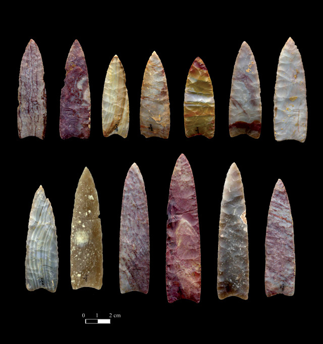
Clovis points — fluted projectile points that were made starting about 13,500 years ago — are named for the New Mexico town near where the distinctive spear points were first found. Credit: Chip Clark, Smithsonian Institution
In a separate study, published in Nature, researchers used a very different technique to date the opening of the corridor: They relied on “shotgun sequencing” of DNA extracted from lake sediment cores drilled from sites in the tightest bottleneck of the corridor. Shotgun sequencing targets short DNA fragments within a sample, which allowed the team to pull a random, unbiased array of sequences from different species from the cores rather than using the more species-specific “bar code” style of sequencing, which would have required the team to make assumptions about which species they expected to find in the cores.
Using the shotgun approach to determine what species were around at different points in time within the cores, the team found that the first terrestrial plant life dated back to 12,600 years ago, with large grazing animals — and perhaps humans — following soon after.
“Given that we know humans were in South America by 14,700 years ago [at the Monte Verde site in southern Chile], we can definitely say that the first humans [in the Americas] did not use this corridor,” says Mikkel Pedersen, a paleoecologist at the University of Copenhagen in Denmark and lead author of the Nature study. “People migrating later, from the north and from the south, could have used it, but not the first colonizers. They must have taken an alternate route, most likely along the Pacific Coast.”
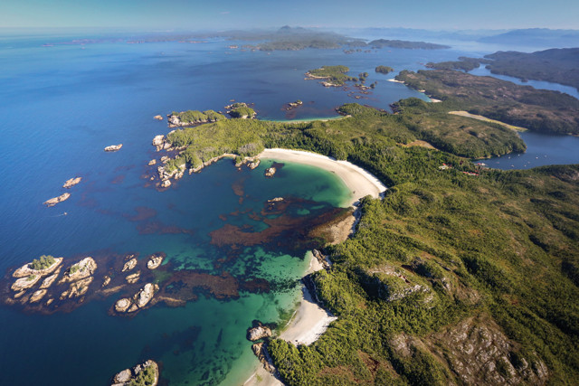
Calvert Island, off the coast of British Columbia, has been ice free since about 15,000 years ago. Researchers working with the Hakai Institute have found traces of Paleoindian habitation in the intertidal zone. Credit: Hakai Institute and Keith Holmes
For archaeologists working along the Pacific Coast, the new findings about the inland ice-free corridor are somewhat vindicating. “I’ll admit a certain amount of schadenfreude,” Mackie says. “There’s a lesson there: Do your geoarchaeological work before you assume the preconditions of your model.”
The challenge to proving the first colonizers took a west coast route is the lack of archaeological evidence along the coasts: rising sea levels over the last 15,000 years have drowned whatever scant evidence was left by the first colonizers. Only in a few places have rising sea levels and post-glacial isostatic rebound balanced out to keep coastlines relatively stable.
There is plenty of evidence to be found, if you know where to look for it, Mackie says. “Archaeologists have traditionally been very pessimistic about finding evidence along the coast,” he says. “And that has led a lot of people to turn away from the coastal route, even though most would admit that it was a viable route.”
About 15,000 years ago, sea level along the Pacific margin of North America was 150 meters lower than today, and finding artifacts can feel like searching for a needle in a drowned haystack, Mackie says. But you can’t just draw a line a few hundred meters offshore and call that the paleo sea level: Topography, isostatic rebound and erosion all complicate the reconstruction of past shorelines. “It takes a lot of grunt work to establish sea-level history, but the payoff is being able to read the ancient landscape, which gives you a much better chance of finding stuff,” he says.
In some places, where the weight of glacial ice pushed the land down during the last ice age, isostatic rebound of the crust since has actually raised the land surface at about the same rate that sea level has risen locally, creating a zone of relatively stable shorelines. “Reconstructing sea-level histories is one of the most time-consuming, but also one of the most important, steps for coastal archaeologists,” says Duncan McLaren, an archaeologist at the University of Victoria. “We’ve been looking for places that lie at what we call the sea-level hinge — where sea-level rise and isostatic rise have conspired to keep [the relative local] sea level relatively stable.”
Using a combination of pond-basin coring, sedimentary-exposure testing and radiocarbon dating, McLaren and his colleagues have identified onshore and intertidal areas along the sea-level hinge around the Hakai Passage, an inundated channel off the coast of British Columbia north of Vancouver Island. Some of these onshore and intertidal zones have maintained the same relative sea level within a few meters for the past 15,000 years. “This stability is key not only because it gives us onshore access to old shorelines, but also because these places [were] exposed for enough time for archaeological materials to accumulate.”
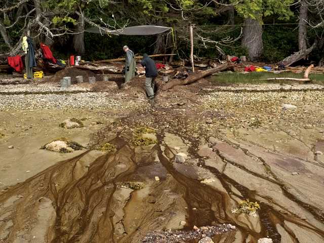
Footprints at Calvert Island were found beneath about a meter of sand. Burial in sand can help preserve artifacts. Credit: Hakai Institute and Joanne McSporran.
The oldest and most exciting paleosite that McLaren’s team has uncovered is south of the Hakai Passage on Calvert Island, just north of Vancouver Island, British Columbia, where human footprints buried under a meter of beach sand in the upper intertidal zone were dated to 13,200 years ago. The footprints are pressed into light-gray clay and covered by a fine layer of black sand. Radiocarbon analysis of organic material found between the layers that contain the prints revealed their ancient age, and analysis of the size and pattern of the prints paints a picture of two adults and a child walking along the coastline — faint traces left by some of the earliest travelers in North America. “Coming across these was quite fortuitous, and so far they’re the earliest evidence of human occupation we’ve found in this area,” McLaren says.
Mackie’s work looking into possible ancient coastal migration routes has taken him to Haida Gwaii, an archipelago farther north off British Columbia with a long history of human habitation. Determining when the Pacific Northwest coast, which would not have been immune to the icy grip of the Pleistocene, might have become passable is important for determining whether it could have offered the earliest route for people coming to the Americas. Mackie and his colleagues have uncovered evidence — in the form of bear dens littered with salmon carcasses — of a potentially habitable landscape dating back to 17,000 years ago. “Bears are a good analogue species for humans: They’re big, terrestrial, omnivorous, territorial and slow reproducers. If you have an environment that bears can live in, it’s pretty safe to say you have an environment that humans can live in too.”
For now, the earliest definitive evidence of humans at Haida Gwaii that Mackie’s team has uncovered dates back 12,800 years. “That’s not very old compared to what’s coming out of places in Florida or Texas, but it’s certainly boosting our optimism,” Mackie says. “A few years ago, a date around 13,000 years ago would have been sensational, but now it’s just a sign we should keep looking. To be really relevant in the search for the first Americans, we should be finding coastal sites in the 14,500 to 16,000 range. That’s what we’re working toward.”
The Channel Islands, off the coast of Southern California, have never been connected to the mainland, even when sea levels were much lower. And yet, artifacts and human remains dating back to 13,000 years ago have been found on the islands — evidence that the earliest colonizers probably traveled by boat, says Jon Erlandson, an archaeologist at the University of Oregon.
“Archaeologists used to think that boats were invented about 10,000 years ago, because the oldest boats found date to around that time. But if you look at islands around the world that have never been connected to the mainland, you’ll find evidence of human habitation going back 50,000 years,” Erlandson says. “The evidence from southeast Asia, Japan and the Pacific Islands is pretty clear: People have been seafaring for many tens of thousands of years. What was to stop them from traveling by boat to the New World?”
The insistence that the first colonizers were strictly land-dwellers is left over from the Clovis First model, which was enamored with the idea of spear-wielding hunters as the first colonizers, says James Adovasio, an archaeologist at the Senator John Heinz History Center in Pittsburgh. “For some ridiculous reason, we have all but ignored the role of watercraft and boats in the colonization of the New World,” he says.
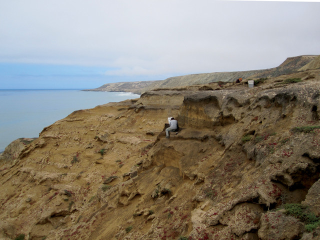
An archaeologist excavates an 11,700-year-old, deeply buried paleocoastal site on Santa Rosa Island in the Channel Islands off the coast of California. Credit: Jon Erlandson.
With several tens of thousands of kilometers of coastline, archaeologists can narrow their search for early American sites around this region by looking at the landscape through the eyes of hunter-gatherers, Erlandson says. Archaeological sites aren’t scattered at random; people were attracted to certain places and features, such as river deltas and overlooks.
One way to avoid the expense of underwater archaeology is to look for features of the landscape that could have pulled people away from the shoreline to areas farther inland that would have remained high and dry. On the Channel Islands, Erlandson and colleagues have zeroed in on inland features such as springs, caves and rock shelters, “toolstone” outcrops, and overlook sites up on high ground with commanding views of the ancient coastline.
The technique has paid off: The team has found more than 80 sites ranging in age from 8,000 to 12,200 years old, including hundreds of bifaces (stone tools chipped away on both sides to form a sharp edge) and stem points (projectile points with a tapered neck for attaching to an arrow or spear shaft), “none of which look anything like Clovis technology,” Erlandson says. The tools appear to be about the same age or slightly older than Clovis tools, and more closely resemble tool technology found in Japan from 16,000 years ago. “The tools we’ve found on these islands look very similar to Japanese specimens, even though they are separated by more than 10,000 kilometers and 3,000 years,” he says.
The Pacific coast has been preferred by archaeologists studying the first Americans, but some of the oldest-known archaeological sites have been found along the Atlantic coast. At the Page-Ladson site south of Tallahassee, Fla., stone tools and butchered mammoth bones dating to 14,450 years ago were recently found in a sinkhole at the bottom of the Aucilla River.
About 15,000 years ago, lower sea levels would have made the landmass of Florida twice as large as it is today. The Page-Ladson site, which now sits 5 kilometers from the Gulf of Mexico, would have been more than 240 kilometers from the coast, hinting at a culture of hunter-gatherers who were adapted to making their living inland, away from the coast. How people got to Florida so early is an open question, says Jessi Halligan, an underwater archaeologist at Florida State University and lead author of a study published last May in Science Advances announcing the find. “Florida is pretty far from the initial point of entry into the Americas, no matter what model you follow,” she says.
Fossils found in Florida from exotic species such as sloths, gomphotheres, jaguars and capybaras — better known from Mexico, Central and South America — point to a possible migration pathway from the Southwest, rather than across the Midwest, as was assumed under the Clovis model.
With lower sea levels, the Gulf Coast would have been an entirely different landscape, says Andy Hemmings, an archaeologist at Mercyhurst College in Erie, Pa. “The exposed continental shelf all along the Gulf of Mexico, known as the Gulf Coast Savanna Corridor, may have been a major migration corridor, not just for animals but for people too,” Hemmings says. Very few fossils of these exotic creatures have been found elsewhere in the U.S. except for Florida. That suggests the route they once took is now underwater — especially given that some of the earliest archaeological sites in the Americas are actually found in South America, such as at Monte Verde in southern Chile, which was occupied by 14,700 years ago and perhaps as early as 18,500 years ago.
“The oldest-known sites in North America are on the Atlantic seaboard,” says Michael Collins, an archaeologist at Texas State University in San Marcos. And in some places, such as Parson’s Island on the Chesapeake Bay, the artifacts bear more resemblance to tool technology found in Europe than anywhere else in North America or Asia. “The technological antecedents to Clovis aren’t found in Asia or Beringia or anywhere along that route,” Collins says. “The closest examples we’ve found come from the Solutrean of Spain and France, so some of us have turned our heads in that direction.”
But the superficial similarities among such tools aren’t enough to convince some researchers that there’s a connection between them or that they represent anything more than a convergent evolution of ideas. “The Solutrean Hypothesis is very divisive,” Hemmings says. Only a few artifacts have been found in the mid-Atlantic region and many of those are controversial because of questionable dating or an incomplete understanding of the stratigraphy where they were found, he says.
For example, in 1974, a Solutrean-style knife known as the Cinmar biface was dredged from the seafloor 100 kilometers off the coast of Virginia, along with a mastodon skull that was dated to about 22,000 years old. But many question whether the knife should be assumed to be the same age as the skull. Still, the landscape where the tool was found has been underwater for at least 16,500 years, providing an impressively old minimum age for the artifact.
More recent excavations on Parson’s Island on the Chesapeake Bay have turned up a cluster of Solutrean-type points and tools in layers of soils dated to 21,000 years old. “Here, we have good stratigraphic context, really good dating, with artifacts found in place. If that material were found in Alaska, it would be the holy grail,” says Bruce Bradley, an archaeologist at the University of Exeter in England. “The only problem here is location, location, location. People are very resistant to the idea of an Atlantic migration, even though it would have been just as feasible as a Pacific migration,” he says, assuming explorers likely would have followed the edge of the northern ice pack, subsisting by fishing and hunting marine mammals like the Inuit do today.
Bradley first proposed the Solutrean Hypothesis at a conference in 1999 “as something interesting that should be tested. But it quickly became an idea that had to be defended in the face of a lot of negativity,” Hemmings says. “I’m not a huge fan of the hypothesis myself, but I do think it deserves proper vetting. With all the glaring gaps in our understanding of the peopling of the Americas, it’s dangerous to dismiss an idea without due process. We have to remember that we aren’t writing the story. It has already been written. It’s our job to figure it out based on the clues we find.”
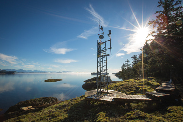
The Georgia Straight pictured from the Quadra Island Field Station off the east coast of Vancouver Island. The finding of more and more Paleoindian sites along both the Pacific and Atlantic coasts lends support for the idea that the first Americans traveled to North and South America by boat. Credit: Hakai Institute and Grant Callegari.
As potential routes into the Americas other than the inland ice-free corridor are opening up to scrutiny, “we are now entering a period of intellectual and theoretical ferment, in which many ideas are being explored,” Adovasio says.
“Nothing says there was just one route. We need to entertain all hypotheses,” Collins adds. “My personal view is that waves of people have been coming into the Americas for a long time. Some came on foot, some came by boat across the Pacific and some came across the Atlantic. It was a long-term process, not a single event.” Studies of modern and ancient DNA have also hinted that the influx was likely complicated, involving multiple waves of people, from multiple gene pools, and possibly, from multiple directions.
Finding early sites, especially along the now-drowned coastlines, will always be a challenge because the footprint of early people was slight. Sometimes, all they left behind was a single tool or a few footprints.
“We have to remember that all we have are snapshots — very disconnected moments in time. But when you look at all these early sites, what’s most striking is their diversity. This diversity is something we are just now coming to appreciate,” Adovasio says. These sites represent a variety of successful lifestyles, he says, suggesting “there is more than one way to colonize a continent.”
© 2008-2021. All rights reserved. Any copying, redistribution or retransmission of any of the contents of this service without the expressed written permission of the American Geosciences Institute is expressly prohibited. Click here for all copyright requests.