
by Mary Caperton Morton Friday, April 3, 2015
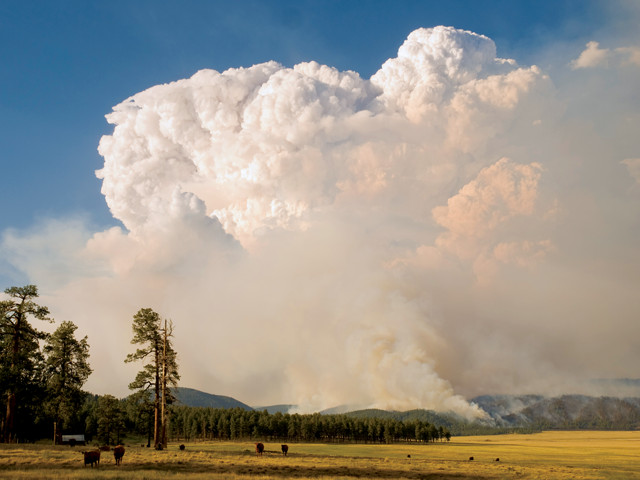
When it struck, the 2011 Las Conchas Fire was the largest wildfire in New Mexico's history. Credit: Kari Greer/U.S. Forest Service.
At about 1 p.m. on June 26, 2011, a wind-downed power line sparked a blaze in the Las Conchas area of Santa Fe National Forest. It would become the largest fire in New Mexico’s history at the time. Within hours, the flames spread to cover more than 160 square kilometers, threatening the town of Los Alamos, home of Los Alamos National Laboratory (LANL), which develops nuclear fuels and safeguards nuclear weapons, among other activities. Now, a new study identifies why the fire spread so far so fast, and the results may have implications for fire management practices in other mountainous regions.
“Between the hours of 8 p.m. and 3 a.m., the Las Conchas Fire exploded from 8,000 acres to 43,000 acres [about 32 to 174 square kilometers],” says Jeremy Sauer, an atmospheric scientist at LANL who participated in the new study, which was presented at the annual meeting of the American Geophysical Union in San Francisco in December. To determine how two atmospheric effects — pyro-cumulus clouds and mountain waves — may have contributed to the fire’s overnight blow-up, a team of scientists at LANL, led by Young-Joon Kim, used a computer model that combines atmospheric dynamics with fire physics. Other participating project members included Rodman Linn, Jesse Canfield, Keeley Costigan, and Domingo Muñoz-Esparza, all at LANL.
Pyro-cumulus clouds are towering plumes of water vapor and soot that rise from very large wildfires and that “look very much like large cumulus storm clouds,” Sauer says. By modeling different wind scenarios, they found that the plume created by the Las Conchas Fire may have collapsed in the night due to wind patterns known as mountain waves, which produce gusty surface winds in the evening as air currents cool and descend through mountainous terrain. This would have resulted in “a rapid intensification and spread of the fire,” Kim says.
This scenario also helps explain other anomalous behavior exhibited by the Las Conchas Fire, which increased in intensity overnight and spread rapidly downhill toward Los Alamos. “Typically, fires settle down during the night, and also tend to burn more rapidly uphill, because the flames are reaching upwards,” Sauer says.
The Las Conchas Fire’s distinct pattern has implications for fire management strategies in mountainous regions, Kim says. “Usually, firefighters are safer downhill from the actively burning area, but not in this case,” he says, adding that “fires situated on the leeside [or downwind] of a mountainous region are likely to be fanned by these wind patterns.”
The Las Conchas Fire was exceptional for how fast it spread, but the blow-up was not surprising given the dry conditions at the time, says Charles Maxwell, a fire-predictive meteorologist at the Southwest Coordination Center in Albuquerque, N.M., which oversees firefighting operations for the state. “Conditions were aligned that night for this to happen: It was an exceptionally dry summer and a very windy night,” Maxwell says. “It turned into one of those fires that are so dangerous it’s best to just get out of the way.”
The new study provides a scientific explanation for what firefighters saw in the field, as they struggled to turn the fire away from Los Alamos, says Maxwell, who was not involved in the new study. “This fire exhibited strongly wind-driven characteristics throughout its duration,” he says.
The study also highlights ways in which operational firefighting models are lacking, Maxwell says. “This [new] research model is very detailed,” he says, much more so than the models that firefighters typically depend on when trying to predict fire behavior in the field.
Closing the gap between theoretical research models and field models that predict actual fire behavior won’t be easy. “It’s going to take billions of dollars and lots of computing power to apply this kind of model toward predicting where a fire is going and how hot it’s getting,” Maxwell says. “We’re nowhere near this level of detail in actual operational capabilities.”
© 2008-2021. All rights reserved. Any copying, redistribution or retransmission of any of the contents of this service without the expressed written permission of the American Geosciences Institute is expressly prohibited. Click here for all copyright requests.