
by Lauren Milideo Tuesday, April 8, 2014
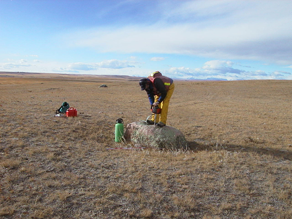
Researchers sample a boulder known as a glacial erratic to determine when it was deposited. Credit: Lionel Jackson.
The existence of an ice-free corridor through Canada during the climax of last glaciation, which allowed the first Americans to cross the Bering land bridge from Siberia and move south (about 13,000 years ago), has long been postulated in North American archaeology. Now, research based on the exposure ages of glacial rocks found in the corridor suggests a puzzling conclusion — that the open pathway closed several thousand years prior to 20,000 years ago and didn’t open again until between 13,000 and 12,000 years ago, well after the first Americans were in the Americas.
The findings, presented at last year’s Paleoamerican Odyssey conference, along with other recent findings, may leave researchers back “at square one,” with no conclusive evidence of when or how the first people arrived in North America, says Lionel Jackson, a geologist at Simon Fraser University in British Columbia and a co-author of one of the studies presented at the meeting.
The fundamental question of when and how the first North Americans arrived in the Americas starts with what migration route they took down into the midcontinent," he says.
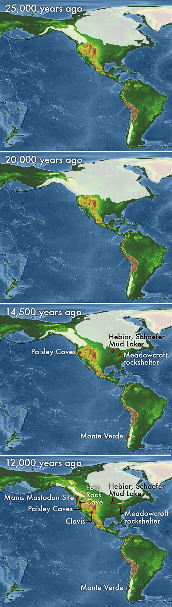
This series of maps shows the generalized glacial extent in North America as the Cordilleran and Laurentide ice sheets waxed and waned. From top to bottom, the maps show ice extent at about 25,000 years ago, 20,000 years ago, 14,500 years ago and 12,000 years ago. Credit: basemap by NOAA NGDC; modified by Kathleen Cantner, AGI.
For decades, an ice-free corridor between the Laurentide and Cordilleran ice sheets that was open about 13,000 years ago was viewed as the answer. The corridor would have provided entry for the Clovis people, named after Clovis, N.M., where this culture’s telltale stone tools were first found, to travel south through central Alberta into the Americas. “The idea that Clovis was first … was essentially orthodoxy for many years,” Jackson says.
But over the decades, the discovery of several archaeological sites that date to well before the supposed ice-free corridor was open — including Manis Mastodon Site in Washington (dated to 13,800 years ago), Paisley Caves in Oregon (dated to 14,500 years ago), and Monte Verde in Chile (dated to 14,800 years ago) — have chipped away at the Clovis First hypothesis.
Additionally, geologists have puzzled over the relationship between the two Late Pleistocene ice sheets in Alberta, the Cordilleran and the Laurentide, Jackson says. “It had been controversial … for many years as to what the nature of the interaction was between the Cordilleran and the Laurentide ice sheet during past glaciations,” he says. Some evidence suggested that the corridor repeatedly opened, as the ice sheets melted back, and closed, as the ice sheets advanced and joined together. It was thought “that this was a kind of repetitive event,” Wilson adds.
To solve the puzzle, researchers needed to examine the rocks left by the glaciers in the postulated ice-free corridor, says lead author Mark E. Swisher, a volunteer at the University of Oregon’s Museum of Natural and Cultural History. The ice-free corridor is coincident with what’s known as the foothills erratics train, a series of exotic quartzite rocks, ranging from smaller pieces to house-sized boulders, hugging the eastern side of the Rocky Mountains in central Alberta, Canada.
“It’s thought that these rocks fell onto glaciers up in the mountains and were transported out of the [Canadian Rocky] mountains into the foothills,” Jackson says. In order for them to be strung out in a straight line all along the foothills and down into Montana “they would have to represent a zone of coalescence between glaciers that came out of the mountains and the Laurentide ice sheet,” he says.
So, Jackson went back to the rocks. The first task was to determine when these glacially carried rocks were deposited. Previously published radiocarbon dates had provided estimated ages for the ice’s mid-Alberta openings, but not for its closure, Jackson notes. Furthermore, “radiocarbon is very difficult to use in that part of the world,” he says, due to contamination from nearby carbonate rock and coal. So Jackson and co-author Fred Phillips of New Mexico Institute of Mining and Technology turned to cosmogenic exposure dating, using chlorine isotopes, in the erratics train to determine when the rocks had been deposited after being plucked by glaciers from the mountains of Jasper National Park. Their results, published in a series of papers starting in 1999, showed that no ice-free corridor existed at the climax of the last glaciation.
Jackson and colleague Laurence Andriashek of Alberta Geological Survey also correlated stratigraphic data and radiocarbon dates from boreholes drilled by the Alberta Geological Survey with stratigraphic data and radiocarbon dates from cliff-exposed sections in the Saskatchewan River system, which had been studied by Jackson and others. Finally, using observations of spillways, strandlines, surface deposits and other features, workers from Alberta Geological Survey mapped locations of Alberta’s glacial lakes, which Jackson and his colleagues used to establish the location and extent of the lakes that blocked northern access to the corridor.
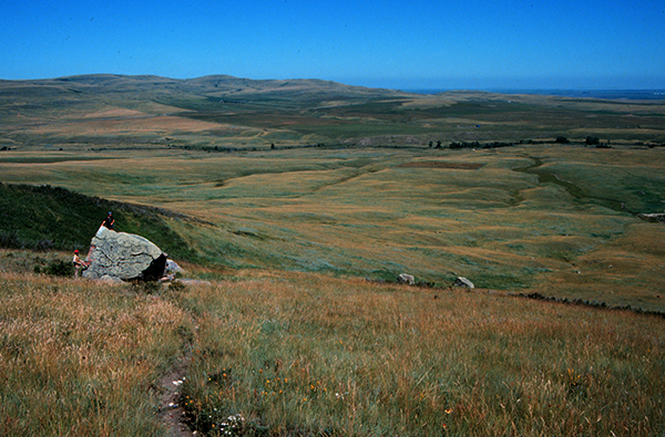
A series of exotic quartzite rocks, ranging from smaller pieces to house-sized boulders, known as the foothills erratics train, hugs the eastern side of the Rocky Mountains in central Alberta, Canada. Credit: Lionel Jackson.
The “synthesis of the cosmogenic dating and a complete picture of the glacial stratigraphy of Alberta and the Great Plains of southern Canada and the north-central United States to the east, which all came together at the same time,” were key, Jackson says. The results, published in the scientific literature between 2011 and 2014, show that before about 20,000 years ago, an ice-free corridor existed in central Alberta. Furthermore, the paleomagnetism recorded in the glacial deposits underlying the Great Plains indicates that during consecutive glaciations throughout the Pleistocene, the western margins of successive Laurentide ice sheets expanded farther west before ultimately joining the Cordilleran sheet to block the corridor during the last glacial maximum.
The latest research, Swisher says, shows that, during the entire Pleistocene, “there was only one coalescence of the ice.” Additionally, Jackson says, “we can actually show approximately where the limits of the penultimate ice sheet were, and really demonstrate that there was always some kind of an ice-free corridor until this last glacial maximum, which was really a totally unique event.”
By combining diverse data, the authors are “providing a much richer context for our studies than we’ve had before,” Wilson says.
The results have significant implications for glacial geology and North American archaeology, Jackson says. “At the height of the last glaciation, which in that area would have been 16,000 years ago … there was essentially coast-to-coast ice from British Columbia right to the Atlantic Ocean,” Jackson says. And there was just no way people could have come down through the center of the continent, he adds. So, he says, with the supposed ice-free corridor closed during this crucial period of human migration, focus must shift to other possible explanations, such as an open passage along the coast — or that they came much earlier.
Swisher, Jackson, Dennis Jenkins of the University of Oregon, and their colleagues suggest the corridor’s earlier and later openings could have provided passage. Several thousand years prior to 20,000 years ago and since between 13,000 and 12,000 years ago, people could have migrated through the corridor to the center of the continent. However, there is also evidence that large glacial lakes may have blocked passage for another thousand years or more.
With all this evidence on the table, Jackson says, “we’re really not sure when people got here to the New World, and how … whether it was originally down the coast, whether they came overland — essentially we’ve gone back to the drawing board.”
“The real question now is: How early was it?” Wilson asks. “Was it 16,000 years ago? Was it immediately after the ice was retreating, maybe 14,000 or 13,000 years ago?” And the question extends across the entirety of the Americas, Swisher notes. If the dates for the extremely old sites in South America are reliable, he says, then “how did those people get there?” Further work might include consideration of new migration routes and reconsideration of old dates, Jackson says. “Some areas or deposits that might have been considered too old to be of interest, or where the dates were [thought to be] wrong probably should get looked at again.”
© 2008-2021. All rights reserved. Any copying, redistribution or retransmission of any of the contents of this service without the expressed written permission of the American Geosciences Institute is expressly prohibited. Click here for all copyright requests.