
by Nia Hurst Monday, April 9, 2018
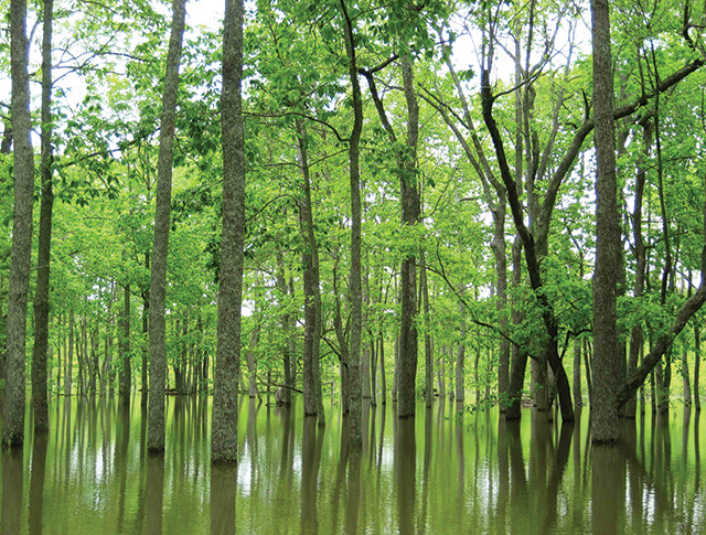
Bottomland hardwoods are a predominant wetland type in the Mississippi Alluvial Valley, the historic floodplain and valley of the lower Mississippi River. Credit: U.S. Fish and Wildlife Service.
Nitrogen giveth and nitrogen taketh away: It’s been estimated that roughly half of the world’s population today could not exist without nitrogen fertilization. Although land area on Earth remains roughly the same on human timescales, population continues to rise, requiring more intensive and rigorous use of existing agricultural land and the creation of more agricultural lands to meet the ever-growing demand for food. One way humanity has supported population growth is through the manipulation of nitrogen, a limiting nutrient in terrestrial ecosystems. In 1913, the advent of the Haber-Bosch process, which artificially converts nitrogen gas to bioavailable ammonia, revolutionized access to nitrogen and all but eliminated nitrogen limitation in terrestrial ecosystems. Now, nitrogen fertilizers are often heavily applied to croplands to increase plant growth and productivity.
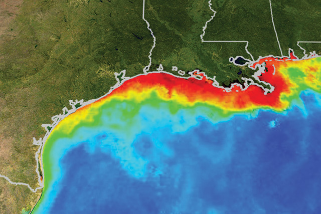
Each summer, a dead zone appears off the coast of Louisiana in the Gulf of Mexico. Reds and oranges on this map indicate high concentrations of phytoplankton and sediment. Credit: NASA/Goddard Space Flight Center Scientific Visualization Studio, 2004.
The problem, however, is that nitrogen fertilizers don’t remain on agricultural lands. Much of what’s applied is washed into local waterways and eventually makes its way into larger water bodies. The Mississippi River, for example, delivers 1.5 million metric tons of nitrogen (60 percent of which is in the form of nitrate) per year to the Gulf of Mexico. Thus, despite the many benefits of nitrogen fertilization, nitrogen pollution of our aquatic systems has become pervasive, resulting in a range of detrimental impacts, from harmful algal blooms to enormous dead zones.
Wetland scientists have long suggested that wetlands — which, because of their filtration abilities, are sometimes called the “kidneys” of an ecosystem — could provide the panacea for the nitrogen problem. But few large-scale projects (besides those specifically designed for wastewater management) have been implemented to test this theory. Now, thanks to a wetland restoration project in Louisiana that’s been running since 1998, scientists have more evidence that restoration and reconnection of floodplain wetlands can significantly reduce nitrogen delivery to the Gulf of Mexico.
One of the better-known signs of nitrogen pollution are dead zones — areas where the water contains little or no oxygen (hypoxia or anoxia). Dead zones can be created when excess nitrogen enters aquatic systems and causes an exponential increase in algae, known as an algal bloom. The subsequent death and decomposition of this organic matter deplete oxygen from the water column, negatively impacting aquatic life.
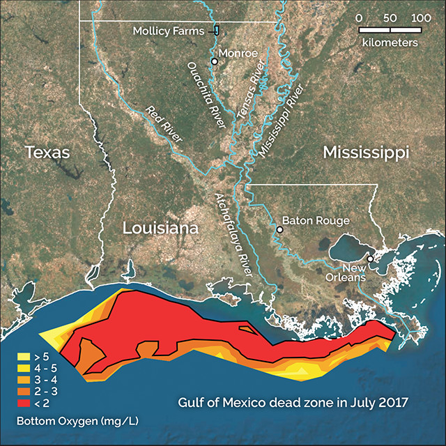
Areas of low oxygen known as dead zones are caused by excess nutrients, such as nitrogen, entering waterways like the Gulf, where it fuels the growth of enormous algal blooms. When the algae die, decomposition depletes oxygen from the water column. This map shows the oxygen levels measured in the dead zone in July 2017. The Mollicy Farms restoration site is indicated at the top of the map. Credit: K. Cantner, AGI, after N. Rabalais, LSU/LUMCON.
While these areas of low oxygen occur around the world, one notable dead zone reappears each summer off the coast of Louisiana in the northern Gulf of Mexico. Hypoxic water creation in the Gulf is primarily driven by excess nitrogen delivery, specifically nitrogen in the form of nitrate. Hypoxic water in the northern Gulf results in the loss of fish habitat, slowed shrimp growth, disrupted spawning patterns, and the death of aquatic species that can’t escape the area. In recent years, the Gulf dead zone has averaged approximately 15,000 square kilometers. Last year, the dead zone was the largest ever recorded, at 22,720 square kilometers, or about the size of New Jersey.
The nitrogen that creates the annual dead zone in the Gulf is primarily delivered by the Mississippi River, the longest river in North America. The Mississippi drains 41 percent of North America and flows through the middle of America’s breadbasket, where the majority of crop production and fertilizer application occurs. Approximately 58 percent of the land in the river’s drainage basin is used for agriculture, with more than 7 million metric tons of fertilizer applied annually.
This fertilizer input, in conjunction with the impacts of more than 72 million people living within the watershed, has significantly affected the water quality in the river and resulted in a dramatic increase in its nitrate load in recent years. Prior to 1972, the river’s average yearly nitrogen export was about 300,000 metric tons; since 1980, that average has hovered around 1.5 million metric tons per year.
Wetlands can remove nitrate from river water quickly and easily, so scientists and environmental groups are working to restore as many as possible, including this one near Lake Chapeau, Terrebonne Parish, Louisiana. Credit: NOAA Restoration Center, Erik Zobrist .
In 2015, the Mississippi River/Gulf of Mexico Hypoxia Task Force — a committee of representatives from federal agencies, including the Environmental Protection Agency and NOAA; state agencies from a dozen Mississippi River states; and the National Tribal Water Council — established a goal to reduce the amount of nitrate being delivered to the northern Gulf by 20 percent by 2025, to reduce the size of the dead zone.
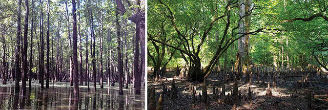
Bottomland hardwood forests (shown here during wet and dry seasons) are typical throughout the U.S. Southeast, including the Mississippi River Valley. The photo at left shows the control site in the Ouachita River Valley, to which researchers compared restoration efforts at Mollicy Farms. Credit: left: Nia Hurst; above: public domain.
Although solutions exist that can help curb nitrogen input to the Gulf, such as reducing agricultural fertilizer input and setting criteria for maximum nitrogen export to the Mississippi, getting all 31 states in the river’s drainage basin to agree on a plan is challenging. And even if it were possible to get all states and their agricultural stakeholders to work together, it would be several years, if not a decade or more, before these solutions would have a significant effect on nitrate pollution. Moreover, none of the solutions would address the issue of legacy nitrate already existing in soil, which would take more than 30 years to flush from the Mississippi River Basin, even if all fertilizer application were stopped today.
Fortunately, there’s something that can remove nitrate from river water within days and is relatively low maintenance, cost effective and sustainable: wetlands. And, luckily, Louisiana has a lot of them.
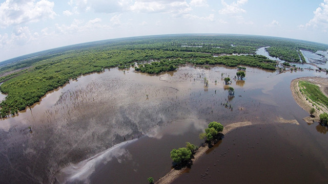
The Ouachita River runs between Mollicy Farms (cleared area at left) and the adjacent control site. Credit: TNC, Steve Hasse.
Once deemed wastelands, to be used as receptacles for trash or as areas where water could be drained to create usable land, wetlands are valuable natural filters that can significantly reduce water nitrate concentrations through denitrification, a process mediated by microbes that converts nitrate back to inert nitrogen gas. Wetlands are such excellent converters of nitrate because they often contain the ideal conditions for denitrification: an abundance of carbon and low-oxygen conditions.
Mollicy Farms was once a bottomland hardwood forested wetland, but was cleared for farming in 1969. By 1997, the Nature Conservancy had acquired most of the site and, by 2001, the group had replanted more than 3 million bottomland hardwood trees. Credit: Nia Hurst.
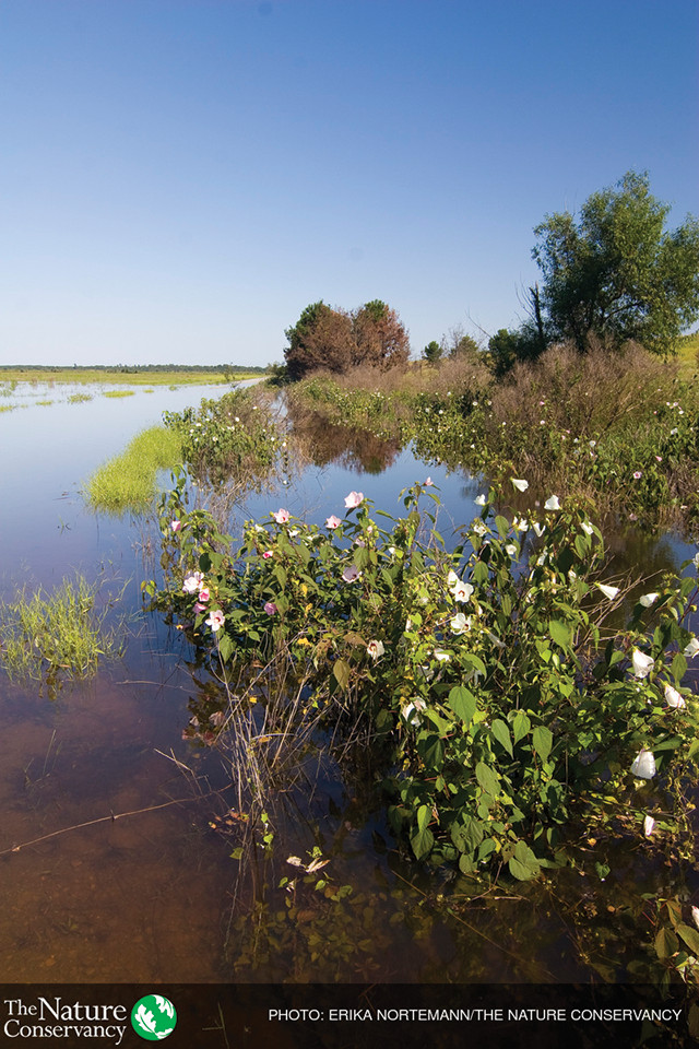
In Louisiana, a predominant wetland type in the Mississippi Alluvial Valley is bottomland hardwoods (BLHs). BLHs are forested wetlands located within the riparian zones of large rivers and streams in the Southeast and South-Central U.S. that experience alternating wet and dry periods, depending upon the river’s water level, or stage. BLHs provide a plethora of ecosystem services and functions, including habitat for terrestrial and aquatic wildlife, flood protection, carbon sequestration and, most importantly in terms of hypoxia, water quality improvement by nutrient retention and removal. In an unaltered system, spring floods of the Mississippi River would overflow the natural banks onto the floodplain, where wetlands would denitrify the water before it reached the Gulf. Historically, the river had abundant floodplain wetlands, but the system has been altered such that floodplains are no longer sufficiently connected to the river.
Almost 80 percent of the BLHs in the lower Mississippi Alluvial Valley have been degraded, primarily through the harvesting of timber and clearing of land for agriculture, reducing BLH cover from 9.7 million to 2.1 million hectares since European settlement began. Along with the degradation and conversion of floodplain wetlands came the construction of 2,700 kilometers of levees along both sides of the lower Mississippi River, which have limited the area of floodplain interacting with river floodwaters by 90 percent since the 1700s. As a consequence of this channelization, much of the Mississippi River is now funneled almost directly into the Gulf, transporting nutrients into the northern Gulf and helping trigger hypoxia. So, even when floodplain wetlands are intact and available, many rarely receive water from the Mississippi or its tributaries, creating a missed opportunity for nitrate removal.
One solution to this pressing problem sounds simple: Restore floodplain wetlands and reconnect them to rivers so they can perform necessary nutrient removal. But can this type of restoration really be successful? And how long would it take to work?
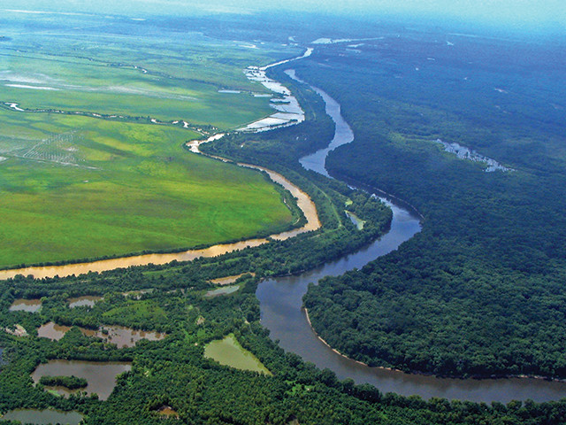
At close to 6,500 hectares, Mollicy Farms is the largest floodplain reconnection and bottomland hardwood reforestation project in the Mississippi River Basin. Credit: Joseph Baustian
A great opportunity to test the use of restored floodplain wetlands to reduce nitrate loads arose in northern Louisiana at Mollicy Farms — a 6,475-hectare site in Morehouse Parish, La., in the Upper Ouachita National Wildlife Refuge. It is situated on the east bank of the Ouachita River, a tributary of the Mississippi River.
Originally a BLH, Mollicy Farms was cleared for row-crop agricultural production in 1969, and a 27-kilometer-long, 9-meter-high levee was built to protect the farm from flooding, essentially disconnecting the site from the adjacent Ouachita River. By 1997, the Nature Conservancy (TNC) had acquired most of the site and, by 2001, had replanted more than 3 million bottomland hardwood trees. Now part of the U.S. Fish and Wildlife Service Upper Ouachita National Wildlife Refuge, Mollicy Farms is the largest floodplain reconnection and BLH reforestation project in the Mississippi River Basin.
Managers planned to breach the levee surrounding Mollicy Farms in 2010, but a high flood year in 2009 did half the work for them by breaking through the levee in two places. It was the first time the site had free access to the adjacent Ouachita River in decades. The managers finished the job the next year by breaching the levee in two additional places, facilitating water movement in and out of the site and restoring floodplain functionality. However, after 25 years of farming at Mollicy, it wasn’t possible to return the natural water flows at the site to pre-disturbance conditions, mostly because of the exorbitant expense. But the connection to the river — along with the recreation of networks of streams, bayous and wetlands previously isolated from the surrounding land to retain water — helped to establish a hydrologically functional floodplain.
However, although BLH vegetation had been planted and water flows between Mollicy and the Ouachita restored, the restoration of biogeochemical functioning and the wetland’s ability to remove nitrate had yet to be investigated. Given that TNC’s restoration goal for Mollicy Farms was to restore site functionality, it was important to determine if the site was capable of removing nutrients. That’s where wetland scientists came in.
We needed to determine the nitrate reduction potential of Mollicy Farms compared to a natural control site, what its contribution to the removal of nitrate from river floodwater would be, and whether the restoration and reconnection of floodplain wetlands could have a significant impact on reducing nitrate export to the northern Gulf of Mexico.
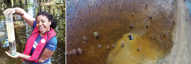
An aerial view (far right) of researchers, including the author (right), collecting soil cores from Mollicy Farms and the control site to compare nitrate reduction rates and related biogeochemical properties between the two locations. Credit: both: Joseph Baustian.
In summer 2015, Louisiana State University wetland biogeochemist John White (my master’s advisor), TNC wetland ecologist Joseph Baustian and I collected intact soil cores from both Mollicy Farms and a nearby natural control site to compare nitrate reduction rates and related biogeochemical properties at the two sites. We measured nitrate reduction rates by removing site water from the surface of the soil cores and replacing it with a 20-centimeter-deep solution containing 1 milligram of nitrate per liter, then measuring nitrate loss in the water column over two weeks. We also measured microbial biomass, or the abundance of soil microbes, which serves as an indicator for soil health and carbon mineralization. Additionally, we analyzed -glucosidase enzyme activity, which also serves as a proxy for carbon mineralization and carbon quality.
We found that the soil nitrate reduction rate at Mollicy Farms was 11.8 ± 3.37 milligrams of nitrate per square meter per day, while the reduction rate at the control site was 16.4 ± 8.10 milligrams of nitrate per square meter per day. Although the nitrate reduction rate at Mollicy Farms was lower than that at the natural site, there was only a 28 percent difference in reduction between the sites, which demonstrated that hydrologic restoration has improved the ability of Mollicy Farms to remove nitrate from the Ouachita River.
Researchers found that restoration and hydrologic reconnection of Mollicy Farms to the Ouachita River produced a positive effect on water quality in the Ouachita and also the Mississippi. Credit: Erika Nortemann, TNC.
However, both microbial biomass and soil enzyme activity were significantly lower in Mollicy Farms (82 percent and 65 percent lower, respectively) compared to the natural site. The discrepancy between different soil characteristics at the restoration site versus the natural site highlights that not all soil functions will follow the same rate of recovery. Even as microbial biomass and enzyme activity are much lower at Mollicy Farms, nitrate reduction is relatively high, despite dampened related soil conditions. This suggests that while some factors (like nitrate reduction) may rebound quickly at a restored site, others may take longer to recover.
The Mollicy Farms restoration project is now part of the U.S. Fish and Wildlife Service Upper Ouachita National Wildlife Refuge. Credit: Erika Nortemann, TNC.
Overall, we found that the restoration and hydrologic reconnection of Mollicy Farms to the Ouachita River has produced a positive effect on water quality in that river and, consequently, the Mississippi River. Based on the average nitrate reduction rate in Mollicy Farms soils, the five-year average of annual flooding days at the site (105 days), and the size of the area that is likely to flood when the Ouachita River reaches bank-full stage (60 percent, or 3,874 hectares), our data show that Mollicy Farms’ soils can remove an average of 48.1 metric tons of nitrate from the Ouachita River every year. If a standard 15-pound bag of fertilizer contains 28 percent nitrogen, the average annual nitrogen removal by Mollicy Farms would be equivalent to more than 25,200 bags of fertilizer.
This is just a drop in the bucket, however. The restoration and hydrologic reconnection of Mollicy Farms alone will not significantly reduce nitrate loading in the Mississippi River or nitrate delivery to the northern Gulf of Mexico, but it can serve as an example for future floodplain restoration projects. TNC and the Lower Mississippi River Conservation Committee have identified more than 300 additional, albeit smaller, sites along the Mississippi River Basin that are suitable for restoration, with some sites being designated specifically for hydrologic restoration. Combined, these restoration projects could go a long way toward reducing nitrogen loading in the Gulf.
© 2008-2021. All rights reserved. Any copying, redistribution or retransmission of any of the contents of this service without the expressed written permission of the American Geosciences Institute is expressly prohibited. Click here for all copyright requests.