
by Bethany Augliere Monday, August 29, 2016
“Are you sure this is right? It feels like we are headed to Neverland,” my boyfriend asked me while hiking last weekend. We were in the country’s newest national monument — Katahdin Woods and Waters National Monument — a remote area of about 35,400 hectares in north-central Maine, designated by President Obama under executive authority last Wednesday, one day before the 100th anniversary of the National Park Service.
As a recent transplant to Maine, I decided to check out the site, just a two-hour drive away from my place in Alexander near the coast. We loaded up the camping gear, the dog and the road atlas and were on our way — but, as we discovered upon reaching the entrance, this is not Acadia National Park.
There is no visitor center filled with park rangers, no gift shops, and not even paved roads. Right now, there isn’t even a fee to enter, although, a new office for the monument just opened in the nearby town of Millinocket. The only signage letting you know you’ve arrived is a single piece of paper, fresh off the laser printer and displayed in a plastic sheet protector reading, “Katahdin Woods and Waters National Monument,” which is posted on an old gate and sign to Loop Road. Loop Road is a 24-kilometer dirt road that marks the entrance to the southern section of the monument, with scenic viewpoints, hikes and swampy ponds. A nearby kiosk displays a map.
Choosing a part of this large park to explore felt daunting, so after some research of the area, we decided on Loop Road.
Just reaching the entrance of the monument required driving on an active logging dirt road for about half an hour. Every so often, we saw signs reading “This Road Owner Says National Park No!” indicating the decade-long controversy surrounding this land, which was donated by Roxanne Quimby, the co-founder of Burt’s Bees personal care products, on Aug. 23, 2016, to the U.S. Department of the Interior.
For our first adventure, we hiked Barnard Mountain, a 7-kilometer round-trip trek to the summit. The trail begins on a section of the International Appalachian Trail — an extension of the Appalachian Trail from its terminus in Maine that continues 3,000 kilometers to Newfoundland, Canada. We walked uphill along a gravel logging road for 2.4 kilometers, crossed Katahdin Brook, and saw plenty of signs of moose, including prints and scat. This region is one of the best for finding the elusive Maine moose.
When we finally reached the trailhead, which turned into the woods, we started zigzagging up the mountain on switchbacks, surrounded by maple and birch trees, and the occasional large boulder — one you can even walk through. Surprisingly, the trail has no markers. Though we could easily follow the narrow path now, in a few weeks after the leaves fall, it could be difficult.
After sweating through the muggy woods, we reached the cool and breezy summit — an open granite ledge, rising 491 meters above sea level. From the top, we glimpsed Mount Katahdin in the distance, the end of the Appalachian Trail, which sits in the adjacent Baxter State Park and is Maine’s highest mountain at 1,605 meters.
Although we saw few people all day, I was surprised to find a large group of hikers also at the summit, and even more so when we realized who it was. Sally Jewell, the U.S. Secretary of the Interior, was out exploring the park with Lucas St. Clair, Quimby’s son.
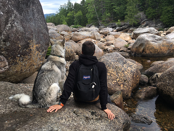
The boulders at Orin Falls; the creek is a nice place to cool off and relax. Credit: Bethany Augliere.
After Barnard Mountain, we hiked to Orin Falls, a long series of cascades over massive pink-tinged boulders, in a section of the Wassataquoik Stream. The granite rocks get their pink hue from an alteration in the feldspar, where the biotite becomes chlorite. The flat, 9.7-kilometer round-trip trek to the falls seemed unremarkable at first. The only wildlife we encountered was the occasional American toad — Maine’s only toad — and the region’s relentless and ferocious mosquitoes, which my DEET-free bug spray did nothing against. But the end was worth it. The boulder-laden stream with pockets of clear water was a refreshing place to cool off and enjoy the scenery.
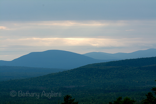
The views from the scenic lookouts and the summits of some of the hikes in the new national monument make getting to the remote location well worth it. Credit: Bethany Augliere.
After Orin Falls, we ended the day by completing Loop Road, passing by ponds and creeks filled with frogs and beaver dams. Unfortunately, we didn’t see any moose. But as the sun set, haunting calls of loons pierced the silence. I know I only saw a tiny sliver of what this region of the North Maine Woods has to offer and I hope to come back soon. After recent trips to parks such as Yellowstone, Acadia and Zion, the lack of crowds here was refreshing. With federal protection and funding, I wonder how Katahdin Woods and Water will change in the future.
For more information about the new park, go to: www.nps.gov/kaww/index.htm.
© 2008-2021. All rights reserved. Any copying, redistribution or retransmission of any of the contents of this service without the expressed written permission of the American Geosciences Institute is expressly prohibited. Click here for all copyright requests.