
by Zahra Hirji Thursday, January 5, 2012
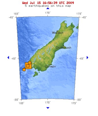
Southern New Zealand experienced a magnitude-7.6 earthquake on July 15, 2009. U.S. Geological Survey Earthquake Hazards Program
A magnitude-7.6 earthquake rattled the South Island of New Zealand at 8:22 p.m. local time Wednesday. No serious injuries or damages have been reported.
The quake's epicenter was 150 kilometers west of Invercargill, off the coast of New Zealand's South Island at a depth of 12 kilometers, according to the U.S. Geological Survey’s Earthquake Hazards Program. Subsequent to the major tremor, the region has experienced several aftershocks ranging in magnitude from 5 to 5.8.
Following the initial quake, NOAA’s Pacific Tsunami Warning Center in Ewa Beach, Hawaii, issued a tsunami warning, but canceled the warning once the waves were discovered to be less than .17 meters (approximately 7 inches). At this time, the center is predicting no Pacific-wide tsunamis.
Over the past two decades, New Zealand has experienced five earthquakes with magnitudes of at least 6.4. The most recent occurred in August 2003, when a magnitude-7.2 earthquake caused minor damages in Otago and Southland and produced landslides around the Fiordland region.
© 2008-2021. All rights reserved. Any copying, redistribution or retransmission of any of the contents of this service without the expressed written permission of the American Geosciences Institute is expressly prohibited. Click here for all copyright requests.