
by Allison Mills Monday, November 2, 2015
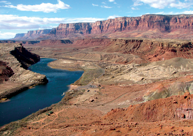
River terraces near Lees Ferry along the Colorado River between Arizona and Utah record how the river has cut and scoured the surrounding landscape. Credit: Joel Pederson.
As great equalizers of topography, rivers and streams whittle down landscapes by alternately scouring away broad flat swaths of sediment and rock, and incising deeply through them. If a landscape — a mountain range, for example — is being uplifted by tectonic forces, this whittling occurs even faster. River incision rates in particular are thus often used to infer past rates of rock uplift. But determining incision rates themselves is not clear-cut. In a new study in Geology, scientists look at one complicating factor in such calculations, what the authors call the “unappreciated effects of streambed elevation variability” on measuring river incision rates.
A river incision rate, at its simplest, is calculated as the vertical depth of rock through which the river has cut over a given amount of time. But other geologic processes are in play, too, including sediment deposition and tectonic uplift, the latter of which imparts more energy and more erosive power to rivers. As these processes fluctuate, rivers incise into landscapes when they have more energy, then level out and scour flood plains when they have less — sometimes laying down sediment and raising a streambed — before cutting down again. The cycle continues as elevations and water and sediment discharges vary. Repeated over time, these processes leave behind a series of terraces representing former streambeds above the modern valley floor.
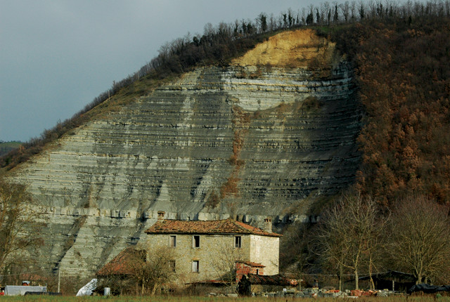
River terraces along the Bidente in Italy's Bidente Valley. Credit: Karl Wegmann.
Geomorphologists have variously interpreted long-term river system behavior on a spectrum from dynamic and unpredictable to regular and cyclical, says Frank Pazzaglia, a geoscientist at Lehigh University and a co-author of the new study. The question of where rivers fall on this spectrum has long been a topic of “lively discussion” in the field, Pazzaglia says. “These arguments focus on the steadiness — or rather unsteadiness — of erosion and uplift through time.”
Sean Gallen, a geoscientist at the Geological Institute at ETH-Zurich in Switzerland and the study’s lead author, likens measuring tectonic uplift via river incision to trying to figure out the vertical level of the horizon while riding ocean swells on a boat. “When you’re moving up and down, it’s hard to get your bearing, and this is also true for valley floors that respond to uplift and erosion,” he says, adding that in studying incision rates, “we have to determine: What is our reference frame?”
In studies of river incision, the current valley floor, or streambed, is often assumed to be an unmoving reference frame, and long-term incision rates are determined using the vertical distance between it and one or more terraces above. But this is not straightforward because the elevation of valley floors changes over time, Gallen says. Based on numerical experiments modeling river incision and streambed elevation changes, he and his co-authors assert that using distance measurements between river terraces and the modern valley floor in such calculations introduces a bias that results in an apparent dependence of the calculated incision rate on the particular time interval over which it is measured. In particular, incision rates determined from younger terraces appear to be faster than those calculated using older terraces. Comparison of their modeling to river incision records from several real rivers validated the findings. Instead of the conventional approach, the team wrote, researchers should calculate incision rates between terraces whose ages are well-known to “minimize rate bias imposed by the dynamic reference frame of rivers.”
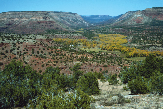
River terraces in the Jemez Valley in New Mexico. Credit: Frank Pazzaglia.
Past research has focused on how assumptions about the timing of geological processes rather than about vertical distances can impact apparent differences in river incision rates. Last year, the authors of a study in Nature analyzed a global dataset of river erosion rates and argued that the unsteadiness of incision processes introduces a systematic error into estimates of long-term incision rates that makes it appear as if erosion rates have increased toward the present day.
The new study in Geology “highlights a potential measurement bias often overlooked in studies of river incision,” says Roman DiBiase, a geomorphologist at Penn State who was not involved in the new study but wrote a commentary about the 2014 Nature study.
The new study does not necessarily undermine the interpretation in the Nature study, he says. Rather, it “offers an alternative explanation for the observation that river incision rates derived from abandoned terraces [suggest] higher [incision] rates for younger terraces.”
Highlighting this observation bias provides a new way to decipher what exactly is being measured with river incision rates, Pazzaglia and Gallen say. As geomorphologists further refine their interpretations of time and distance measurements with respect to incision, their insights will help unravel fundamental questions in geology about how Earth’s surface changes over time.
© 2008-2021. All rights reserved. Any copying, redistribution or retransmission of any of the contents of this service without the expressed written permission of the American Geosciences Institute is expressly prohibited. Click here for all copyright requests.