
by Jon Campbell Monday, December 8, 2014
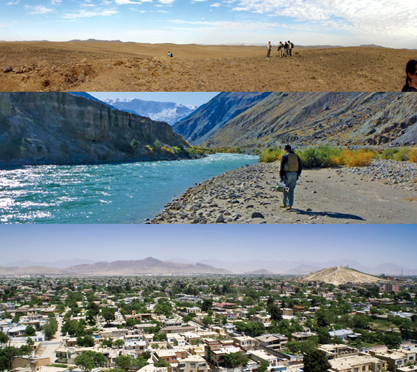
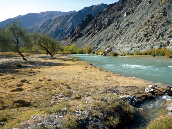
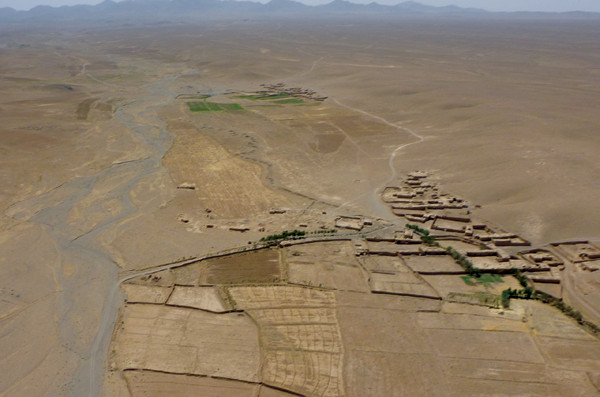
A tale of three Afghanistans: Deserts, mountain streams and growing cities. Credit: top and middle: Thomas J. Mack, USGS; bottom: ©iStockphoto.com/MieAhmt.
Aside from the front-page issues of war and politics, one of Afghanistan’s most critical national needs is safe and reliable supplies of water. The United Nations estimates that Afghanistan’s current population of about 31 million will increase by nearly 80 percent by the year 2050 to approximately 56 million. Such an increase will raise demand on the country’s already stressed water resources. In addition, recent research suggests that global climate change could alter precipitation patterns in Afghanistan. In particular, both the amount and the timing of snowfall received at higher elevations could change, impacting the major source of water for many areas in Afghanistan.
Afghanistan is one of the world’s poorest countries, with an economy largely based on subsistence agriculture. Working in an arid climate on thin margins of profitability and sustenance, Afghan farmers depend on reliable, year-round sources of surface water and groundwater to irrigate their crops and water their livestock. Seasonal flows of streams and rivers fed by melting snowpack high in Afghanistan’s mountains recharge alluvial aquifers located in populated valleys and provide city dwellers with drinking water.
Because Afghanistan is highly susceptible to drought, access to clean, dependable water sources can determine the fate of a village. When the country suffered a drought from 1999 to 2005, whole villages with limited water resources were forced to abandon their land and flee to larger cities and towns. Today, villages abandoned during the drought can still be found throughout the country while refugee camps established for the same reason have become pockets of discontent.
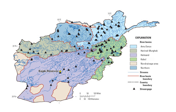
Locations of Afghanistan's major drainage basins, reinstalled streamgage stations and the Kajaki Reservoir, a major source for hydropower and irrigation in the Helmand River Basin. Credit: Thomas J. Mack, USGS.
As the country develops further, additional water supplies will be required for anticipated mining and mineral processing activities, as well as for associated businesses and communities that will be vitally important to Afghanistan’s future stability.
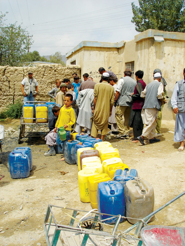
Water is arguably the most important resource in Afghanistan. Here, villagers line up for water at a community well near Kabul. Credit: Robert E. Broshears, USGS.
Citizens of developed countries can take for granted the basic information about water resources that is fundamental for assuring a dependable municipal water supply, for expanding the economic potential of agriculture and industry, and for improving public health. Engineers and government officials everywhere require accurate data about surface water (streams, rivers and reservoirs) and groundwater (aquifers, wells and springs) in order to understand the complex relationship between surface water and groundwater. This body of knowledge, coupled with systematic information about water quality, is necessary to build and maintain water infrastructure and to manage water resources effectively for large populations. In developing countries, such as Afghanistan, this broad perspective is typically very limited or altogether lacking. Following decades of invasion and civil war, Afghanistan lacked the technical capacity, the communication infrastructure, and the modern equipment necessary for effective hydrogeologic investigations of its water resources.
The difficulty of obtaining safe and reliable supplies of water in Afghanistan is heightened by the fact that water-resources data collection was suspended around 1980 due to civil strife and the Soviet invasion. Subsequently, much of the institutional knowledge relating to water resources was lost, most of the country’s water monitoring equipment was destroyed, and the abilities of Afghan water scientists stagnated.
At the turn of this century, Afghanistan’s hydrologic expertise was severely limited. Its scientists had been isolated from the international scientific community and from ongoing technological advancements in the field of hydrology for more than two decades. Then, in October 2001, following the 9/11 attacks, the U.S. invaded Afghanistan.
By early 2002, the U.S. had already begun collaborating with international partners as well as scientists in Afghanistan to rebuild key civic institutions and infrastructure — including those related to water resources. Since then, Afghan scientific knowledge and understanding of the nation’s water resources have improved considerably as a result of institutional capacity developments at various Afghan ministries and nongovernmental organizations (NGOs). Recent developments have begun re-establishing civil hydrologic expertise, and have led to the creation of local and national groundwater monitoring networks and a national climatic network. Although further improvements are needed, these advances should assist Afghanistan’s planners and managers to assess and monitor current and future water resources.

In 2004, U.S. Geological Survey (USGS) researchers arrived at the Afghanistan Geological Survey (AGS) headquarters in Kabul to begin a decade-pluslong collaboration with AGS scientists. Credit: Michael Chornack, USGS.
In early 2004, recognizing the national need for regaining the knowledge of Afghanistan’s water resources, Said Mirzad — a current U.S. Geological Survey (USGS) employee and former director of the Afghanistan Geological Survey (AGS) who previously served as an advisor to the U.S. ambassador in Afghanistan — assisted in negotiating cooperative agreements between AGS and USGS. By July 2004, USGS hydrologists had begun collaborating with their Afghan counterparts.
Since 2004, USGS efforts have focused principally on basic skill-building. For example, USGS scientists have provided training to Afghan scientists and technicians in using modern computerized techniques required for hydrologic monitoring and for maintaining large databases. Since the collaboration began, USGS and Afghan counterparts have released more than 40 reports on the supply and quality of groundwater and surface water sources, including geohydrologic assessments to describe the availability of water resources required for future development of areas with mineral potential such as the copper-rich area of Aynak.
USGS and AGS scientists started with groundwater monitoring in the Kabul Basin. Credit: Thomas J. Mack, Michael Chornack, USGS
One of the first projects USGS and AGS engineers undertook was to investigate water resources in the Kabul Basin. Kabul, the capital, is home to more than 3.3 million people and one of the fastest-growing cities in the world. Although the city is traversed by three rivers, the flow in these rivers decreases dramatically during the summer and fall when large volumes of water are diverted upstream for irrigation. Consequently, Kabul relies principally on groundwater for domestic and industrial water supply. Future water supplies in Kabul could be adversely impacted by decreasing volumes of snowfields and glaciers, as have been observed in recent years.
Starting in mid-2004, USGS researchers have been training scientists from AGS and the Afghanistan Ministry of Energy and Water (MEW) in computer science, GIS and GPS; in setting up and managing complex databases; and in conducting some of the latest field techniques for assessing hydrogeology and water quality. Together, USGS and AGS scientists had inventoried about 150 wells in the Kabul Basin by the end of November 2004. They measured water levels, and collected and analyzed samples for physical, chemical and microbiological properties. In addition to shaping an understanding of critical hydrologic processes in the area, such as how streamflow and snowmelt recharge aquifers in the Kabul Basin, one of the important findings was that streams and groundwater in many areas of the basin were contaminated with high bacterial levels due to lack of sanitation and wastewater treatment.
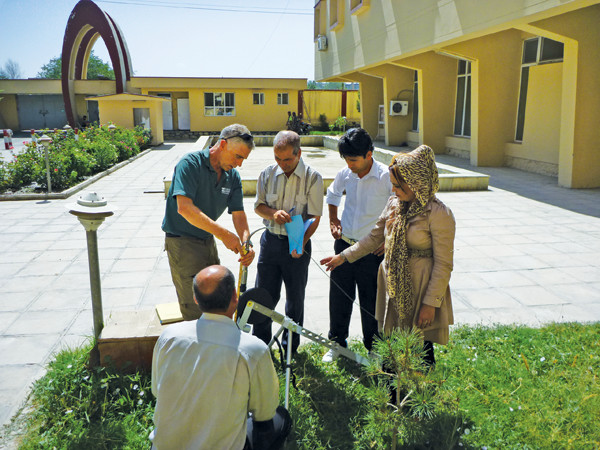
Once USGS scientists were on the ground in Afghanistan, they quickly set about teaching the AGS scientists how to use modern monitoring equipment. Credit: Thomas J. Mack, USGS.
In following years, Afghan and USGS researchers have continued to study the sustainability of groundwater resources in the Kabul Basin. The findings are less than encouraging. Computer simulations of groundwater flow, considered together with projections of population growth and potential climate change, indicate that many water wells may dry up. Additional investigations using the now 10-year record of groundwater levels collected by AGS have documented drastically declining groundwater levels in the city of Kabul at the same time that groundwater levels elsewhere in the basin are recovering from the multiyear drought of the early 2000s. These investigations raise concern for the ability of Kabul’s water resources to meet future needs and dramatically illustrate the importance of the recent water-resource monitoring programs.
By 2010, AGS engineers applying the lessons learned in Kabul had established similar groundwater monitoring networks in the major population centers of Mazar-e-Sharif (with a population of 368,000, the fourth-largest city in Afghanistan), Sheberghan (with a population of 162,000) and Sar-e Pol (with a population of 151,000), all of which lie northwest of Kabul, where many people in water-limited areas could benefit from the information.
Meanwhile, collaborative work with the Danish Committee for Aid to Afghan Refugees, an international NGO, led to the development of a national network of more than 150 wells to monitor groundwater levels. Administered by Afghan engineers, this first national groundwater network will be vital to detecting and assessing regional trends in future groundwater levels and quality.
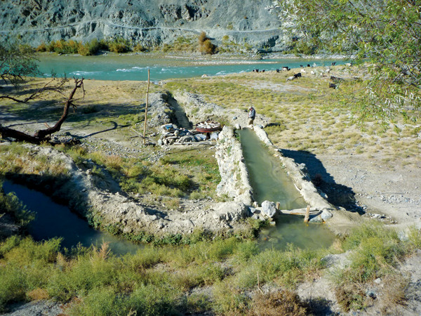
Much of Afghanistan relies on subsistence farming with small irrigation systems running from snowmelt-filled streams such as the Balkhab River. Credit: Thomas J. Mack, USGS.
Reliable streamflow information is fundamental to hydrologic science and water management. Measurements of streamflow are needed to quantify water available for irrigation and direct consumption, as well as for understanding water movement in the hydrologic system as a whole. For example, streamflow is usually both a major source of recharge to, and discharge from, groundwater systems and is thus a key component in understanding the sustainability of groundwater systems. Quantifying streamflow is also an important component for negotiating and maintaining treaties between countries on the sharing of water resources at national boundaries.
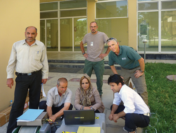
Using lessons learned in the Kabul Basin, AGS scientists have begun installing groundwater monitoring networks in other areas, such as Sheberghan. Credit: Thomas J. Mack, USGS.
In the early 1950s, USGS, working with a predecessor organization to the U.S. Agency for International Development, established a streamflow gaging program in the Helmand River Basin. The basin is a large agricultural region, the watershed for the Kajaki Reservoir, and a potential major source of electrical power in southern Afghanistan. By the late 1970s, Afghanistan had a functioning streamflow and reservoir water-level gaging network that consisted of 169 streamgages distributed across the country. This network operated until 1980 when most streamgages were destroyed or fell into disrepair. From 1980 to the early 2000s, Afghanistan’s original streamflow records were misplaced or destroyed and the data were lost.
From 2006 to 2010, USGS and MEW researchers worked to recover daily streamflow data from whatever historical documents hadn’t been destroyed and could be located. Some data had been secretly taken by Afghan scientists for safekeeping at their own homes — at great personal risk if the documents were found by the Taliban — to preserve them. When the scientists brought the surviving paper copies to USGS and MEW, the data were digitized and loaded into the USGS National Water Information System. Since then, researchers have published reports providing countrywide historical streamflow characteristics, including monthly and annual discharge, monthly and annual flow durations, annual peak discharges, and monthly and annual mean discharges. This information is vital because it provides the basic historical data needed for assessments of future water resources as a result of climate change. The information is now available for all interested parties through a publicly available USGS database.
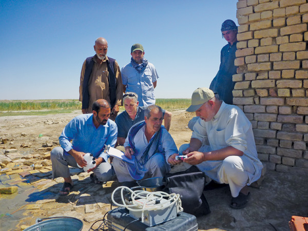
USGS and AGS researchers install water monitoring networks in Aynak. Credit: Thomas J. Mack, Michael Chornack, USGS
Over the past decade, USGS scientists and Afghan partners have also investigated current surface water resources of the Kabul River Basin (where more than 10 percent of the country’s population lives and streamflow is a major source of groundwater recharge), the Aynak mineral area (near the city of Kabul), and the Helmand River Basin.
In the Kabul River Basin and the Aynak mineral area, streamflows have been shown to be highly variable. These flows can be greatly reduced in the summer and fall as runoff from snow and ice in the surrounding mountains is reduced as water infiltrates into basin sediments or is diverted for irrigation. In 2010, the USGS and AGS assessment of Kabul Basin’s water resources found that about half of the shallow groundwater supply wells could become dry or unusable due to declining streamflows and recharge under projected climate change by 2050.
The Helmand Basin is dominated by the Kajaki Dam on the Helmand River. Completed in 1953 with U.S. guidance and funding, the huge dam created a reservoir with a surface area of approximately 2,200 hectares. A source for hydropower (its current capacity is 33 megawatts) and irrigation in the Helmand River Basin, Kajaki Reservoir has had its designed storage capacity of approximately 1.7 billion cubic meters reduced due to infilling by sediment. Recent research indicates that the reservoir likely will have future storage capacity further reduced because of continued sedimentation.
Nationwide, approximately 127 historical streamgages were re-established and supplied with modern equipment from 2008 to 2011 as part of a USGS and World Bank program. Unfortunately, the current level of training of Afghan water scientists and engineers is not sufficiently advanced to effectively operate the streamgage network. The USGS is currently working with MEW on developing necessary training programs for the Afghan scientists.
USGS continues to assist MEW with its national hydrologic information network to assess water resources in the country’s river basins and aquifers for domestic, agricultural, energy, mining and other industrial needs, and to assess critical flows stipulated for transboundary international treaties.
Like most Afghan rivers, the Balkhab is fed by snowmelt. Credit: Thomas J. Mack, USGS.
A critical unknown factor in Afghanistan’s water future is the influence of a changing climate. “May Kabul be without gold, but not without snow,” implores an Afghan proverb. Afghanistan relies on winter snowfall in the mountains to replenish the snowfields and glaciers that supply water to its perennial and ephemeral rivers and streams. Reductions of the mountain snowpack and glaciers due to climate change could have a profound effect on Afghanistan’s water resources.
The Afghanistan agricultural-meteorological (Agromet) project was established on Jan. 1, 2004, to create a countrywide network of agrometeorological stations. By 2014, Agromet was operating 102 stations to record precipitation amounts, snow-cover extent and other meteorological parameters necessary for the calibration of remotely sensed data and climate models. The program produces monthly bulletins and seasonal reports in both English and Dari, the Afghan dialect of Persian, and has trained more than 260 observers from government agencies and NGOs to make on-the-ground climate measurements and maintain monitoring equipment.
Much of Afghanistan, such as the region around the village of Dusar, is a desert, relying on seasonal streamflow from snowmelt for water. Credit: Thomas J. Mack, USGS.
The ability of Afghan government agencies to monitor and analyze variations in climate will allow for proactive measures to be taken to mitigate potential adverse effects to the availability of water resources. Data that demonstrate how precipitation and temperature influence the amount and timing of the availability of surface water for irrigation can be used to select appropriate crops for planting. This knowledge can also be used to predict how much water will be stored in reservoirs and available for irrigation and hydroelectric power generation. The analysis of changes in groundwater levels in response to seasonal and regional variations in climate enables specialists to determine where water supply wells are at risk of going dry. The Afghan government is now poised to operate the climate network and contribute data to larger regional networks for global monitoring.
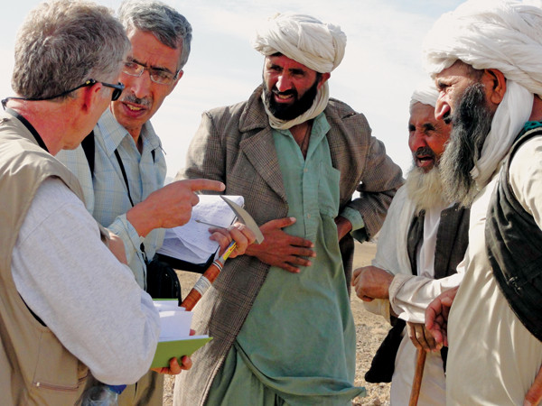
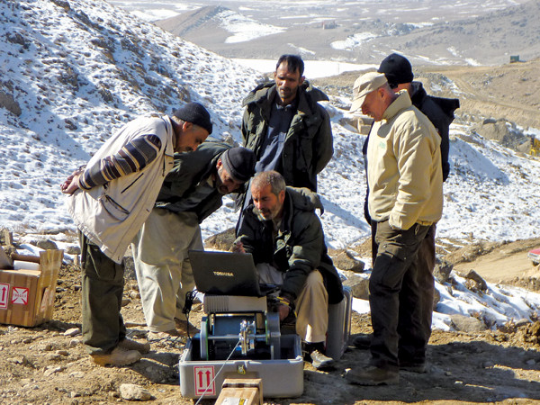
USGS scientist Tom Mack (far left) talks to Afghan village elders through a colleague from AGS (holding hammer) in the village of Dusar in 2010. Mack recalls that "when the Afghan scientist explained to the elders that AGS and USGS were cooperatively searching for copper ore in the hillside, and that finding it would lead to jobs for the local people, the elders politely thanked him and asked if we could help them find water first." Credit: Thomas J. Mack, USGS.
By 2013, the availability of 10 years of data from the AGS groundwater-level monitoring network in the Kabul Basin and from surface water monitoring throughout the country provided a solid reference for understanding the sustainability of groundwater resources in the basin. Future generations of Afghan engineers will likely have the technical ability to construct and run water-resource computer models that will enable them to make long-term predictions regarding Afghanistan’s water resources, but it is the availability of historic water-resource data, including climate data, that will allow those predictive models to be calibrated with past observations.
A comprehensive understanding of Afghanistan’s water resources by its scientists, engineers, political leaders and citizenry is vital for the future of this struggling nation. “Water is more important to Afghanistan than any mineral or other natural resource,” Said Mirzad says. “Urban expansion, more intensive agriculture and prospective mining operations will all require more water, even as we face an uncertain climate future. It is paramount that we learn to use Afghanistan’s water resources wisely.”
This article is based on the work of Tom Mack and Mike Chornack, USGS scientists who have braved risks and devoted years of their lives to help the people of Afghanistan learn about their water resources.
Special thanks to Patrick Leahy, former acting director of USGS and current executive director of the American Geosciences Institute (which publishes EARTH), who was an early advocate of the development of a cooperative geoscience program to rebuild the Afghanistan Geological Survey.
From 2004 through 2007, USGS and AGS activities were jointly conducted under the auspices of the U.S. Agency for International Development. From 2009 to present, these activities have been conducted under the auspices of the U.S. Department of Defense Task Force for Business and Stability Operations.
© 2008-2021. All rights reserved. Any copying, redistribution or retransmission of any of the contents of this service without the expressed written permission of the American Geosciences Institute is expressly prohibited. Click here for all copyright requests.