
by Timothy Oleson Wednesday, June 12, 2013
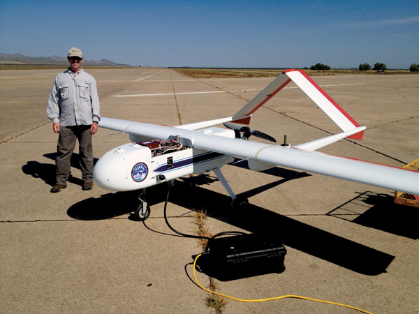
The Sensor Integrated Environmental Remote Research Aircraft (SIERRA) on the tarmac at NASA's Crows Landing Airport in California. Courtesy of Jonathan Glen, USGS
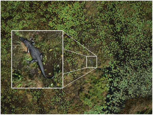
A high-resolution aerial photograph of an alligator near Lake Okeechobee taken from the Nova 2.1 UAV. J. Martin et al., 2012, PLOS ONE
Amid rolling green pastureland dotted with livestock and the occasional cluster of trees, Costa Rica’s imposing Volcán Turrialba rises 600 meters above the surrounding landscape about 40 kilometers east-northeast of San José. On a clear day last March, a light column of volcanic steam rose from Turrialba — as it has steadily for several years — while a twin-propeller airplane made slow passes through the plume and over the mountain’s summit and flank.
The wispy fumes emanating from the volcano, one of a handful of active volcanoes in the country’s mountainous spine created by the subduction of the Cocos Plate beneath the Caribbean Plate, look docile enough. But along with the steam come particulates and noxious gases like sulfur dioxide and hydrochloric acid that pose health hazards for the local population and have been acidifying the rain and leaving behind large tracts of dead vegetation. The rain has “really started to devastate the farms around the volcano,” says David Pieri, a volcanologist at NASA’s Jet Propulsion Laboratory at Caltech, who calls the affected area on Turrialba’s southwest side the “zone of death.”
Pieri and his colleagues, particularly his collaborators from the University of Costa Rica who regularly monitor the volcano, are interested in better understanding the emissions' effects on local ecology and agriculture. But that’s not the only reason they visited Turrialba in March. With its steady flow of vented gas and low risk of an explosive eruption — the last one occurred in 1866 — it is a relatively safe natural laboratory in which to study the dynamics of volcanic plumes in general. It is also an ideal location to test the newest research tool at their disposal: that small aircraft buzzing overhead.
The plane followed a pre-ordained flight path through the sky for about 45 minutes as Pieri’s team, which also includes members from NASA’s Ames Research Center in California and Wallops Flight Facility in Virginia, watched from the ground. Among the scientists, engineers and technicians on hand as it landed in a nearby field was its operator, who had been piloting the aircraft from a laptop.
The airplane — all 2.5 kilograms of it — is an unmanned aerial vehicle, or UAV, called a Dragon Eye, and its ersatz cockpit consists simply of a computer, monitor and antenna set up at the team’s makeshift command station on an abandoned farm at the base of the volcano.
Scientists whose work involves imaging, monitoring or otherwise investigating the outdoor world have gradually been turning to unmanned aircraft in recent years, touting their cost-effectiveness (at least once they are developed), safety compared to manned flights, and versatility, both in terms of where they can operate and what equipment they can carry.
Scientific uses for UAVs, including for weather reconnaissance, aerial surveying of natural resources or hazard monitoring, have been envisioned since early entrepreneurs began developing these types of aircraft more than two decades ago. And beginning in the late 1990s, UAVs were used infrequently as novel platforms for atmospheric observations. But large-scale deployment was stymied by the lack of an emergent commercial market — like that which allowed GPS to flourish — for the aircraft.
In the vacuum, the military became the major end user of the technology, adapting UAVs for combat purposes that have been on prominent display of late in overseas conflicts. As a result, UAVs — or drones as they’re known colloquially, much to the dismay of their backers — have acquired reputations as long-range assassins and agents of espionage. More recently, their potential use in domestic law enforcement has come to the forefront of public attention while, in the U.S., the Federal Aviation Administration (FAA) weighs how to open national airspace to commercial unmanned aircraft, sparking widespread concerns of potential infringements on privacy. (Laws governing UAV use internationally vary considerably. Some countries, including Brazil, France, Mexico and the U.K., for example, currently permit commercial use of small UAVs.) In the ensuing debate, the utility of UAVs in science and research has largely been overshadowed.
The growing use of UAVs for research now is due partly to the miniaturization of scientific instrumentation, which is opening up new applications as the aircraft can be outfitted with a wider array of sensors. The growth has also been spurred by the retirement of military equipment, which several government agencies have gladly repurposed and redeployed.
NASA has a small fleet of various models of UAVs, some of which, like the Global Hawks and Dragon Eyes, are military hand-me-downs. The U.S. Geological Survey (USGS), which facilitates UAV activities on behalf of the Department of the Interior (DOI), primarily uses two models, likewise obtained from the military. NOAA, the Departments of Energy and Agriculture, and a number of other federal and state agencies are also making use of UAVs in research capacities.
Meanwhile, dozens of universities across the country have been establishing programs to actively develop and use unmanned research aircraft. And many private companies are designing and testing their own models with civil, as well as military, applications in mind. Of course, they come with their own high price tags and shortcomings, including, for example, limited payload capacities. And it seems unlikely that they will fully supplant manned research flights or other remote-sensing methods for scientific applications, even with open airspace. But policy and economic concerns aside, researchers using UAVs suggest that the possibilities for their deployment in the natural sciences are almost boundless.
UAVs come in a plethora of sizes and shapes — from traditional airplanes and gliders to multi-rotor helicopters and other bizarre-looking hovercrafts. Large models such as the infamous Predator or the Global Hawk, with roughly 20-meter and 40-meter wingspans respectively, provide the archetypal images of UAVs. Through a partnership with the Department of Homeland Security (DHS), USGS and other DOI agencies have collected data during a few floods and wildfires with a DHS-operated Predator B (a model also known as a Reaper). And among its unmanned research fleet, NASA has a Reaper (dubbed “Ikhana”) and two Global Hawks — passed down from the Air Force — that it uses for long-range weather and atmospheric data collection in projects such as the Hurricane and Severe Storm Sentinel (HS3) mission and the Airborne Tropical Tropopause Experiment (ATTREX).
“When you need a long-range mission … it’s nice to have that arrow in your quiver,” Pieri says of the Global Hawk and its use in hurricane reconnaissance. “But these are big aircraft, they’re complicated, they take a lot of people to operate, and they’re expensive,” he says. “With the small ones we can do quite a few missions with much less money.” And in fact, most current scientific UAV efforts are using small models weighing between about 2 and 20 kilograms.
With the diminutive 1-meter-wingspan Dragon Eye, which looks like a clunky version of an off-the-shelf remote-controlled plane, “we’re trying to do volcanoes on the cheap,” Pieri says. He and his collaborators first started considering UAVs for their work on volcanoes about five years ago, he says. Then last summer, they pounced on an opportunity to pick up nearly 100 Dragon Eyes through a no-cost, General Services Administration-brokered transfer from the Marines. “They’re very robust, rugged little aircraft designed for combat … we figured we ought to be able to use them effectively” for field geology, Pieri says, and “as it turned out, we were right.”
Learn more about the UAVs in the print edition of the July issue, available now.
The volcanologists’ idea was to use UAVs “to penetrate the ash and to get close to these volcanoes and into these plumes, where it’s probably too hazardous for manned aircraft to go.” The NASA team — the only one to make use of the Dragon Eyes for science so far — brought several to Costa Rica to give the scientists a bird’s-eye view of Turrialba and to collect remotely-sensed, in situ measurements of its plume. The noses of the aircraft, which can be swapped out as desired, were variously instrumented with visible light and thermal imaging video cameras, sulfur dioxide sensors, optical particle counters and air sampling devices.
All told, the team made 10 flights with the Dragon Eyes on the planes' maiden science mission, and they “performed beautifully,” Pieri says. “We got some good thermal images of the volcano aside from the sulfur dioxide measurements,” he says, along with temperature, pressure and humidity readings.
In addition, by timing the Dragon Eyes’ sample collections with simultaneous measurements by the Advanced Spaceborne Thermal Emission and Reflection (ASTER) Radiometer aboard NASA’s Terra satellite, the scientists can double-check satellite readings with in situ data. Validation of satellite-derived volcanic ash and gas levels “has been sorely missing,” Pieri says. “That was a major point of interest in the Icelandic eruptions [at Eyjafjallajökull] that closed down European airspace [in 2010],” he says. “People were not as confident in the [satellite-based] models as they would have been if they’d had good calibration and validation data collected routinely.”
About the same time that Pieri’s group was beginning to think about UAVs as a viable and valuable option for field research, USGS was as well. In 2008, the agency opened its Unmanned Aircraft Systems Project Office in Denver to implement UAVs on behalf of DOI agencies, including itself, the Fish and Wildlife Service, the National Park Service, the Bureau of Land Management and others. Using two small UAV models obtained from the Army — the 2-kilogram glider-like Raven and the hovering T-Hawk, which looks something like a souped-up charcoal grill — USGS began flying science missions in 2010.
In its brief existence, the USGS office has flown more than a dozen missions, with several more planned for the rest of 2013. “I’ve had a huge upswing in the number of people across the department asking for UAS missions,” says office project manager Mike Hutt. (UAVs are also known as unmanned aerial, or airborne, systems [UAS] because the sophisticated instrumentation they carry often goes beyond their avionics packages.) One of the reasons why, he says, “is just the cost of helicopter time and aircraft time.” The small unmanned aircraft used for most projects can be flown for less than $3,000, Hutt says, whereas it was costing agencies $30,000 to $50,000 to use a helicopter or aircraft for the same job. Another reason is that UAVs get around issues with satellite data such as their relatively low-resolution and the occasional unreliability of acquisition, for example, due to cloud cover.
So far, USGS’ UAVs — equipped primarily with high-resolution and thermal imaging cameras — have been used to assess fence line damage and potential encroachment of invasive species in Hawaii’s Haleakala National Park; monitor a prescribed brush burn in Florida as a proof-of-concept for future support of wildfire operations; observe impacts such as sediment reallocation on Washington’s Elwha River following removal of the Elwha Dam; and inspect the health of levees along the Missouri River during the massive flooding of spring 2011.
In conjunction with the Office of Surface Mining, Hutt says, the UAVs have also been flown over mines in several states to assess mine safety as well as engineered features like drainage control structures. Using both the Raven and T-Hawk, “we were able to fly over and identify some coal seam fires, which has been a hard remote-sensing problem for us in the past,” he says. “And now we have coal seam fire identification projects in Colorado, Montana, Idaho and West Virginia”
“Really, the early implementers, and the group that has taken the most advantage of it, are [biologists] in wildlife management,” Hutt says. His office has helped biologists in other agencies monitor various large mammals, sea turtle habitats and a variety of birds, including swans, eagles, sage grouse and — perhaps the best example, he says — sandhill cranes. The cranes spook easily when they’re out feeding during the day, he says, making conventional observations from manned aircraft difficult. But by flying a Raven at night over the roosting cranes, “we could fly as low as [23 meters] above them and with the thermal camera actually … do a very accurate count of the number of cranes as they were migrating through the wildlife refuges.” About half of the projects on which his office has collaborated have involved wildlife, Hutt says.
As is often the case in efforts involving relatively young and relatively expensive technology — as even small UAVs still are — collaboration to share costs and expertise can be crucial, whether it’s among federal agencies, between public and private entities, or among groups at various levels of government.
Since about 2000, the Florida Cooperative Fish and Wildlife Research Unit’s Unmanned Aerial Systems Research Group, housed at the University of Florida in Gainesville, has been a partnership among the university, USGS, the Florida Fish and Wildlife Conservation Commission and other agencies. The goal of the program has been “to develop a small UAS for use in natural resources, primarily estimating animal abundance and evaluating habitat,” says Franklin Percival, a wildlife biologist with USGS and the university’s Department of Wildlife Ecology and Conservation, and the group’s program leader.
One reason is safety. A 2003 study published in the Wildlife Society Bulletin reported that aviation accidents resulted in two-thirds of the 91 documented job-related deaths of wildlife biologists between 1937 and 2000. And Percival cites a 2010 incident in which a pilot and two biologists from the Idaho Department of Fish and Game were killed when their helicopter crashed during a mission. That followed at least two earlier nonfatal crashes that year involving wildlife biologists — one in Wyoming and another in Idaho.
Additionally, Percival says, wildlife biologists have traditionally relied on simple counts that are “generally some observer’s notion of how many animals he might see from the ground or from a manned aircraft.” But such counts aren’t always statistically valid or repeatable, he says.
The lightweight Nova 2.1 aircraft that Percival’s team of biologists, remote-sensing specialists and aerospace engineers has built has a 2.7-meter wingspan and can be hand-launched from land or a boat. GPS allows it to fly autonomously using preprogrammed navigation, and an inertial monitoring unit (IMU) records information about the 3-D orientation of the plane in the sky. The GPS and IMU together allow the researchers to precisely geo-reference photographs collected by the aircraft so “you can reliably tell the location to within centimeters,” Percival says.
The aircraft has allowed his group to begin collecting the statistically reliable and repeatable estimates of manatees, alligators and colonial nesting birds in the state that scientists have sought for years, Percival says. It’s much more valuable information “to help manage the population, or to monitor the population, than a count at one point in time.” New collaborations are taking Percival’s team to Idaho this summer to investigate habitat quality for white pelicans, pygmy rabbits and Chinook salmon.
The technology is still developing, so Percival says he looks at the advantages of UAVs in terms of potential. UAVs have “tremendous promise as a sampling tool” in small study areas, he says, where the data can be ground-truthed — with information collected from airboats in the Everglades, for example — and then used to inform larger-scale satellite data.
Where the equipment, funding and expertise are already in place, research efforts with the technology are progressing rapidly.
For several years, Jonathan Glen, a research geophysicist at USGS in Menlo Park, Calif., has been using gravimetric and magnetic surveys to investigate tectonic controls on underground geothermal flow in the vicinity of northeastern California’s Surprise Valley. By partnering with collaborators from NASA Ames, Central Washington University and Carnegie Mellon University, he has been able to pursue his efforts from a new angle.
Last September, Glen and his colleagues took NASA’s Sensor Integrated Environmental Remote Research Aircraft (SIERRA) — a mid-sized UAV with a 6-meter wingspan and 45-kilogram exchangeable payload — to Surprise Valley, equipped with a magnetometer to see how it would fare compared to traditional methods. Currently, ground-based collection of high-resolution gravimetric and magnetic data — used to distinguish subsurface rock formations — is time-intensive, and certain areas are inaccessible, Glen says, leaving big holes in data coverage. And, aside from being expensive and dangerous, low-altitude manned surveys contracted out to commercial operators are typically laid out well in advance of a project, leaving little or no room for on-the-spot changes to flight plans.
Using SIERRA was “an amazing success,” Glen says, noting that a big advantage of using the UAV “was that we were able to look at the data each night and then make new flight plans for the next day” based on where the most interesting features appeared to be. The technology could be used for many geological applications, he says, from mapping faults and monitoring volcano hazards to scouting for mineral and geothermal resources.
With just one season of flying SIERRA under their belt, he says, his team is already plotting even more sophisticated UAV experiments for the future. These include using several aircraft simultaneously, utilizing more advanced aircraft such as the Swift glider and the X-SCAV (eXperimental Sensor-Controlled Aerial Vehicle), incorporating multiple sensors for use on single flights, and integrating payload-directed flight (PDF) controls. The PDF system would automatically loop data collected from scientific instrumentation aboard the aircraft back into the flight plan. In essence, Glen says, the aircraft would not only be unmanned, but self-guided as well, analyzing data to look for fascinating features and determining “where to fly next and how to do so most efficiently without flying over areas we’ve already flown over, for example — and at the same time avoiding any dangers” like mountains or power lines.
“There are a lot of different people working on a lot of different fronts to develop UAS,” Glen says. “I see it as a wide-open field for really expanding capabilities in their fields, and there is a lot that the different types of platforms can offer.”
For his part, Hutt says his prediction is that by 2020 — if not earlier — unmanned aerial systems “will provide the majority of the remotely sensed information that the Department of the Interior uses.” Department agencies will still be flying manned aircraft and using satellites, he says, but data from available UAVs are “just more timely, can be tailored to the project and are cost-effective.”
Despite the potential of UAVs, researchers using the aircraft acknowledge that there are hurdles to widespread deployment in science. For one thing, the current regulatory framework in the U.S. is “fairly time-consuming and cumbersome,” Hutt says. So far at least, broad concerns from lawmakers and privacy advocates nationally and in many states about UAV-related privacy infringement have not had an impact on science missions, both he and Percival say, because the aircraft fly either exclusively over public land or, if need be, written permission is obtained from landowners to fly over private land.
But in order to operate UAVs in U.S. airspace, NASA, USGS, universities and other public entities must first receive a certificate of authorization (COA) from the FAA. To do so, the agencies must certify the airworthiness of their craft and the training of their pilots for each individual project. And even with authorization, operators are constrained by regulations to flying below 1,200 feet (370 meters) and within a 1-mile (1.6-kilometer) radius, limiting the area they can cover. “It probably takes about three months from the time we get an initial call from somebody requesting a mission to the time that we can actually give them the thumbs-up or thumbs-down that the mission has been approved,” Hutt says. “I lose probably 30 percent of the people on the initial call when I describe the COA process.”
Hutt says he is optimistic that the process will be streamlined in the next couple of years as public agencies work with regulators and as the FAA prepares to open national airspace to commercially flown unmanned aircraft, which Congress in 2012 instructed the agency to do by September 2015.
Beyond current regulations, however, economic constraints appear even more restrictive. UAVs may be cost-effective for certain applications once they’re developed, but they are expensive to design, test and build, Percival says. The autopilot system in his team’s plane costs about $5,000, and the combined GPS and IMU add another $7,000. On top of that, he points out, his group destroyed a lot of planes and had to overcome a series of developmental issues before they built a successful aircraft. In natural resources work, he says, UAVs are “not going to be widely used until you can get the price down.”
Commercial use of UAVs is seen by some as a possible solution to the issue of cost, and there is no shortage of companies in the business. Percival notes that the interests of agricultural companies — who may wish to use UAVs for “precision agriculture,” perhaps assessing and treating only drought- or disease-affected portions of crops rather than whole fields — may overlap with those of scientists. And a recent report by the Association for Unmanned Vehicle Systems International, an industry trade group, projected that UAVs would net the U.S. economy 70,000 jobs and more than $13.6 billion within three years after the national airspace is opened.
But “there’s only one thing that matters,” says Tad McGeer, an aeronautical engineer and president of Aerovel Corporation, which is developing its own long-range, autonomous aircraft called Flexrotor. And “it’s not the forecast of some consultant. … It’s money being spent by investors and customers.”
There has been talk about, and development of, UAVs for civil and research applications for 20 years, McGeer says. Many companies currently are building and selling small UAVs like quad-copters for personal use and “short-duration, eye-in-the-sky” applications, but widespread implementation for research hasn’t happened yet simply because “the economics have not been such that there would be a market,” he says.
“We’re chipping away at the problems of cost,” he says, but right now “we can only hope to open little niche markets.” Even in countries outside the U.S. where “aviation regulators are a lot more forward-thinking than the FAA is,” he says, you still don’t see the skies abuzz with UAVs.
Prior to starting Aerovel in 2006, McGeer founded Insitu (now owned by Boeing) in 1992, where he led the development of pioneering UAVs like the Aerosonde for long-range weather reconnaissance and the SeaScan/GeoRanger (refashioned by the military as the ScanEagle) for oceanic and magnetic surveying. Aerovel’s Flexrotor plane — with a 3-meter wingspan and weighing in at about 19 kilograms — is designed to make vertical takeoffs and landings, to stay aloft for more than 40 hours at a time and to carry a payload of about 1 kilogram, features that would make it very useful for scientific applications, McGeer says.
“We hope that it is economical enough that it would actually make these applications viable,” McGeer says. “But that remains to be demonstrated.”
© 2008-2021. All rights reserved. Any copying, redistribution or retransmission of any of the contents of this service without the expressed written permission of the American Geosciences Institute is expressly prohibited. Click here for all copyright requests.