
by Mary Caperton Morton Friday, April 1, 2016
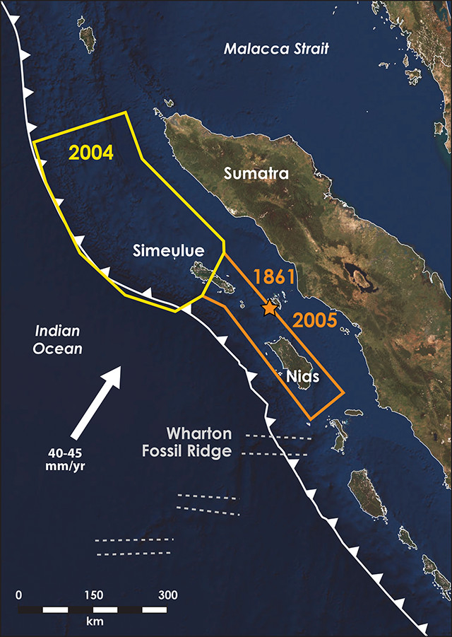
Earthquakes off the coast of Sumatra in 2004 and 2005 ruptured different neighboring segments of the subduction zone. A raised ridge between the segments may have blocked the ruptures from propagating simultaneously. Credit: K. Cantner, AGI.
In late March 2005, a magnitude-8.7 earthquake struck off the northwest coast of Sumatra, Indonesia, rupturing a portion of the Sunda Megathrust Fault and further terrorizing a region still reeling from the devastating 2004 Boxing Day earthquake and tsunami just three months prior. The March quake, however, could have been far larger than it was, according to new research. Scientists have identified a topographic barrier on the oceanic Indo-Australian Plate — which descends under the Sunda Plate in the Sumatra Subduction Zone — that may have stopped the 2005 rupture from propagating farther.
“Along subduction zone margins, faults don’t usually break in one single event, but rather in sections or segments,” says Tim Henstock, a geophysicist at the University of Southampton in England and lead author of a new study in Geology investigating the 2005 event. For example, the 2004 and 2005 Sumatra earthquakes ruptured different, although adjacent, segments of the megathrust. “Our goal was to look for physical causes of segmentation along this plate boundary.”
Henstock and his colleagues set out to map the topography of the Indo-Australian Plate in the vicinity of the 2005 event using a combination of seismic reflection data, bathymetric measurements and detailed measurements of Earth’s gravity field. “In Sumatra, the biggest challenge in mapping the downgoing plate is the shape of the seabed, which is extremely complicated,” Henstock says. “This is one of the most challenging environments for using these kinds of methods.”
Among other features, the team identified an isolated 15-by-30-kilometer mass rising 3 kilometers above the seafloor close to where the 2005 earthquake rupture stopped. The topographic feature is part of the Wharton Fossil Ridge — a now-inactive spreading zone where much of the crust beneath the Indian Ocean was created before the zone died out about 40 million years ago — that is now being subducted.
Geologists have long questioned whether subduction of topographic highs like the Wharton Ridge strengthens a downgoing plate, or weakens it by fracturing the plate, which allows fluids in and makes it more likely to rupture. “Different people have argued for both of those scenarios in different locations,” Henstock says. Seismic monitoring of the region indicates that the Wharton Ridge itself is aseismic, suggesting that while the region around it may be weakened by fracturing and fluids, the ridge is strengthening the plate boundary locally and stopping ruptures from propagating past it.
There is also compelling paleoseismic evidence that an 1861 earthquake that ruptured this same segment — from central Simeulue Island to just south of Nias Island — appears to also have been stopped by this topographic high, Henstock says.
The paleoseismic history of the region, combined with the detailed recordings of the 2004 and 2005 events, makes the Sumatra margin an ideal location to study how seafloor topography affects segmentation and seismicity along subduction zone margins, says Susan Bilek, an earthquake seismologist at New Mexico Tech who was not involved in the new study. “You really need to have the history, combined with the imaging, to nail down where the slip took place and tie that to the topography of the plate interface.”
A better understanding of how topography influences other subduction zone plate boundaries is needed in order to make predictions about which are likely to fail in segments and which might fail all at once, Bilek says. “Whether topography weakens or strengthens the fault seems to depend on the tectonic setting, and maybe on the height of the topographic feature.”
Interactions between seafloor features and subduction zones may also be occurring off the coasts of South America and Japan, she says. “Along the South American margins there are seamount features that may be affecting segmentation of the fault, and there’s some evidence in Japan for a topographic feature at the southern end of the 2011 rupture,” she says. “But the imaging hasn’t been done yet at this level of detail.”
© 2008-2021. All rights reserved. Any copying, redistribution or retransmission of any of the contents of this service without the expressed written permission of the American Geosciences Institute is expressly prohibited. Click here for all copyright requests.