
by Sara E. Pratt Monday, May 9, 2016
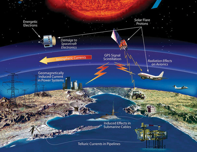
A NASA schematic showing the technologies and infrastructure that can be affected by space weather. Credit: NASA.
Growing up in California during the Space Race, Thomas Berger was fascinated with aeronautics and aviation, so when he arrived at the University of California at Berkeley, physics seemed like the natural choice. After graduating with a degree in engineering physics, Berger took a job with Lockheed Aircraft in Burbank. But he soon decided it was not for him and returned to graduate school at Stanford, where he discovered a new passion: solar physics.
His first job out of graduate school was, ironically, back at Lockheed Martin, where, this time, he stayed for 15 years primarily developing magnetograph instrumentation for ground- and space-based solar telescopes. In 2012, he moved to the National Solar Observatory in Sunspot, N.M., as the project scientist on the Daniel K. Inouye Solar Telescope under construction on Haleakala Volcano in Hawaii.
In August 2014, Berger was appointed director of NOAA’s National Space Weather Prediction Center (SWPC), in Boulder, Colo., which is responsible for monitoring and forecasting solar and geomagnetic events that can impact satellites, power grids, GPS, communications, navigation and many other technologies that modern societies rely upon. He took the helm at SWPC at a critical time for the space weather community: the government was developing the country’s first space weather strategy, and critical gaps had emerged in the system of satellites that comprise Earth’s space weather sentinel.
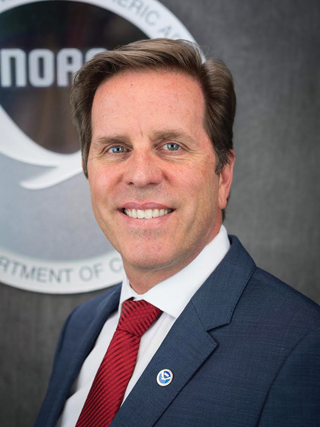
Thomas Berger is director of NOAA's National Space Weather Prediction Center (SWPC) in Boulder, Colo. Credit: NOAA/SWPC.
Berger recently spoke to EARTH about the importance of open data in maximizing our return on “big science” investments like telescopes, the role of international cooperation in funding satellite missions, and what is needed to ensure our ability to predict a severe geomagnetic storm.
SEP: Who influenced your early interest in science?
TB: My father, a doctor, was also very interested in physics and astronomy. But probably the most influential element in my early life, in terms of science, was the original Exploratorium in San Francisco. There was no admission fee; you just walked in, and there were all these things sitting around on the floor like a giant warehouse full of physics toys. It was really just a wide open experimental space, which was wonderful for kids.
SEP: At Lockheed you worked on the Hinode project — a Japanese mission to fly a telescope to observe the sun. What lessons from that work did you try to implement at the National Solar Observatory?
TB: One thing about Hinode that is very good is that the data are rapidly made publicly available. We had a very good pipeline from the telescope to the data center where people could pick up the data. And we also operated the telescope in a way that was different from a lot of previous missions in astrophysics and solar physics. We used what’s been called “service mode,” in which the telescope was continually doing different [observing] programs proposed by the community; and the proposal process was very easy. You just had to fill out a form saying, “I would like Hinode to observe this location at this time using these instruments,” and we would do it. Then your data would show up immediately after that at the data center. So you didn’t have to put in a lengthy proposal, you weren’t in charge of running the telescope, and you didn’t have to go to the control center, which is the “principal investigator” model.
This had been done with other satellites as well, including some NASA satellites for solar observing. But this was very controversial for the ground-based [telescope] community, which was entrenched in the principal investigator mode, where you have a small group of people taking and essentially sitting on those data; and the number of papers that came out based on the data from those missions was quite meager.
As soon as you give the data to the public, there is an amplifying effect on your return on investment in the telescope. The number of papers out of the Hinode mission in six years was many times that produced by ground-based solar telescopes, which had never been used in service mode until Hinode showed the way.
SEP: Why do we need to predict space weather? Who needs to know about it?
TB: Space weather prediction, in my view, is analogous to a combination of hurricane and tsunami forecasting. It’s a constantly changing phenomenon, and there is space weather that is significant outside of just the extreme events — smaller storms that occur regularly. But it’s really the big storms that occur due to huge eruptions on the sun that we can’t yet predict that we have to watch out for. The biggest driver of space weather on Earth is the sun. But we’re finding, as we develop models of the ionosphere [the upper layer of Earth’s atmosphere that interacts primarily with the solar wind], that the lower atmosphere of Earth — the troposphere and stratosphere — also has to be included in models because waves in those regions propagate up into the ionosphere and rearrange it. You have to understand the entire system of Earth’s atmosphere, Earth’s magnetic field, and Earth’s interactions with solar wind and with the solar magnetic field.
The major [consumers of space weather forecasts] are anybody operating in space, obviously, who needs to know about the solar wind conditions and the solar magnetic field conditions, and anybody on the ground who’s using GPS and/or the power grid. We all rely on the power grid, which is potentially vulnerable to a large-scale geomagnetic storm. Satellites are also a consideration: You can short out a satellite because of electron pileup just due to solar wind changes.
There are a lot of things we need to do on a daily basis to monitor the solar wind and the solar weather, but we also can’t lose sight of looking out for the “big one” as part of our mission.
SEP: Why did it take so long for the U.S. to develop a space weather strategy?
TB: It wasn’t until the ‘70s that it became obvious that if we had a really big geomagnetic storm, such as last occurred in May 1921, which blew out the New York City subway switching system and disrupted telegraph service nationwide, you could potentially have a wide-scale, prolonged blackout. The farther north you go, the stronger these geomagnetically induced currents are, so it’s conceivable that Washington, D.C., could be hit, requiring the government to move. And any time you require the government to move, under what’s called the continuity of government scenario, that’s a big deal.
In 2012, President Obama asked John Holdren, his science advisor, to develop a new national strategy specifically to ensure that we can predict, mitigate and respond to an extreme geomagnetic storm. The strategy deals with what we would do as a nation if we got hit with one of these extreme geomagnetic storms that could potentially black out large portions of the country and damage the grid to the point where it would take weeks, or perhaps even months, to get it back up.
SEP: Are we currently in a position to implement that strategy?
TB: An implementation plan was part of the strategy. In terms of where we stand today, hopefully, we will be able to observe a big eruption in the first place if one occurs, so that we’d know we need to respond. I say “hopefully” because one of the telescopes we use to observe these eruptions is the Solar and Heliospheric Observatory (SOHO), an ESA-NASA research satellite that’s 20 years old. It has what’s called a coronagraph, a special type of telescope needed to see magnetic eruptions from the sun. The original mission was three years, but luckily, it was designed very well and it has lasted 20 years. But it’s all we’ve got. If that were to fail tomorrow, and then we were to have one of these massive eruptions from the sun, we would be blind to the eruption. So we’re in a precarious position, and part of what we addressed with this national strategy was pointing out that we are in a very precarious position.
SEP: What tools do we need to effectively predict space weather?
TB: What we need is a satellite out at L1 [Lagrangian point 1] that has a coronagraph and solar wind measurement instrumentation on board so that you can see these eruptions coming. And ideally, you’d want to have a magnetograph, so that you have the magnetic field of the sun being observed, the explosions in the corona being observed, and the solar wind being measured as these things swept by. But, if you’re looking straight on at an eruption, it’s sometimes hard to tell exactly which direction it’s moving in. So what you really need is to have at least two viewpoints — one on the Earth-sun line and another at a side position.
In the golden age, we had three. We had the two satellites of the Solar Terrestrial Relations Observatory — STEREO A and STEREO B — and SOHO. We had three views of every coronal mass ejection (CME) coming off the sun for about four or five years. And during that time, the predictions of CME arrivals at Earth got very good. But since the STEREO satellites went behind the sun [in 2014], we’ve gone back to the state we were at before, in which we were only accurate to plus or minus six to 12 hours ahead of the CME arrival time.
The STEREO satellites are just coming around from the back side of the sun, so they’re looking at the back side of the sun right now, which isn’t very useful if you’re trying to predict Earth-directed eruptions. The other problem is that Stereo B [malfunctioned] and they don’t know if they can get it back. So there’s really just STEREO A. It’s rotating back around toward Earth so STEREO A will be helpful in viewing Earth-directed eruptions in about three or four years, but then it will keep orbiting and be out of position again. We need a stable platform out at the L5 Lagrangian point to give us at least a second viewpoint for measuring CMEs.
SEP: So our observing capabilities have actually declined?
TB: Yes. We got good, and then people said, “Oh, you guys are good at predicting space weather. I guess you’re done.” But the reason we were good at predicting space weather arrival times is because we had this temporary situation with multiple NASA research satellites that allowed us to get better at it. One of my main goals in this job is to try to get back to the situation where we have permanent operational presence at at least two points in space, ideally three.
However, it’s really hard to sell people on the fact that you’re going to spend a billion dollars on these missions for something that might not happen for another 60, 70 or 100 years. I think it’s a key societal question that we need to ask and our politicians need to answer: How much money do we spend on probabilistic events, events that may or may not occur in our lifetimes, but if they do, could be extremely severe? That balance is, I think, very difficult to achieve.
SEP: Why is the Deep Space Climate Observatory (DSCOVR) mission, which you worked on and which launched in February 2015, important?
TB: DSCOVR is the first operational space weather satellite dedicated to space weather operated by NOAA, not NASA. So it’s a huge milestone in that sense. It represents a big step in the direction of [making] space weather prediction a national priority, like what the National Weather Service does — 24/7, absolutely reliable communications of predictions of environmental effects. But that means we need dedicated instrumentation just like weather satellites. And DSCOVR is the first step in achieving that.
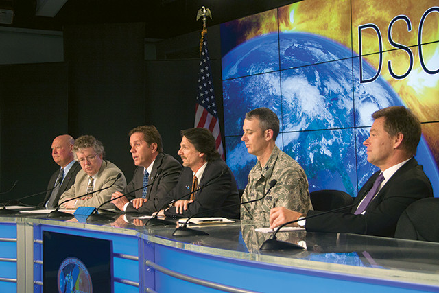
Berger speaking at a briefing on NOAA's Deep Space Climate Observatory (DSCOVR), which launched from Kennedy Space Center in Florida on Feb. 11, 2015. DSCOVR, a joint mission with NOAA, NASA and the U.S. Air Force, provides the ability to monitor solar wind in real time. Credit: NASA/Jim Grossman.
DSCOVR was developed from the repurposed Triana spacecraft, originally designed just to view Earth. It was never intended to have a large number of solar instruments on board, and a coronagraph unfortunately could not be accommodated. In the end, DSCOVR has solar wind measurement instruments, which are very important because as that eruption comes sweeping by the DSCOVR spacecraft, it takes another 15 to 30 minutes before the satellite signal gets to Earth. So it at least gives you that 15-to-30-minute warning time, but if you don’t have a coronagraph looking at the eruption as it comes off the sun, you won’t be able to gauge how fast it’s going and when it’s going to arrive.
SEP: What’s the role of international cooperation in these missions?
TB: These deep-space missions are very expensive. For example, DSCOVR has a nominal five-year lifetime. Hopefully, by 2020, perhaps 2022, NOAA will launch its replacement, which will include a coronagraph. However, NOAA has not committed to launching a mission to the L5 Lagrangian point due to cost constraints, for example. Fortunately, international partners, such as the U.K. Met Office, which also runs a 24/7 space weather forecasting service, are looking at launching a mission to the L5 orbit that would complement NOAA’s L1 mission.
That’s the ideal scenario in terms of international cooperation. NOAA takes care of one requirement, and the international community supplies others, and we eventually end up with a system of sentinels in positions to give us good CME predictions through international cooperation.
SEP: When was the last time you saw an aurora, and can you appreciate them aesthetically, or do you just think about the potential danger?
TB: Well, actually, it’s funny. That’s a good question, and the answer, which is uncomfortable to provide, is: I’ve never seen an aurora. I’ve always wanted to. On transatlantic or transpacific flights, I always try to position my seat at a window so that I can look north. I think it would be fantastic, but I haven’t had the chance to make a dedicated trip to see one yet.
© 2008-2021. All rights reserved. Any copying, redistribution or retransmission of any of the contents of this service without the expressed written permission of the American Geosciences Institute is expressly prohibited. Click here for all copyright requests.