
by Terri Cook Thursday, March 10, 2016

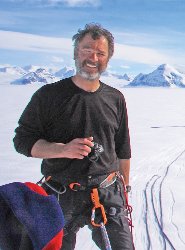
Ted Scambos. Credit: NSIDC, University of Colorado.
As a young boy, Ted Scambos was fascinated by space and technology, and spent many hours watching aircraft take off and land at the Air Force bases where his father, a pilot, was stationed. For his birthday or Christmas, he says he would often ask for a new telescope or a book about the planets. By sixth grade, Scambos had decided to become an astronomer. But by high school, his attention shifted from outer space to chemistry, and he set up an elaborate chemistry set in his parents’ basement. As Scambos’ interests evolved, he gradually realized that although astronomy and chemistry were both very hands-on disciplines at first, the deeper he delved, the more esoteric they became. Instead, he found himself drawn to geology, especially after discovering how much he enjoyed fieldwork.
After completing his doctorate in 1991 at the University of Colorado at Boulder, Scambos embarked on a distinguished career in Antarctic glaciology that has spanned two and a half decades. Following a postdoctoral position at NASA’s Goddard Space Flight Center in Greenbelt, Md., Scambos returned to the University of Colorado, where he now serves as the lead scientist at the National Snow and Ice Data Center. In addition to using remote sensing to study Antarctica’s glaciers, Scambos frequently collaborates with international teams to tackle ambitious projects like surveying new areas of the ice sheet, placing instruments on a drifting iceberg, or studying the sea ice floating on the Southern Ocean — fieldwork that has taken him to Antarctica 18 times.
Scambos has appeared on PBS, CNN and NPR, and his publications have been cited in many newspaper and magazine articles discussing climate science. He recently spoke with EARTH about how remote sensing has changed the field of glaciology, why he loves working in the harshest climate on Earth, and how to glue ocean sensors to elephant seals.
__TC: How did you become interested in remote sensing?
TS:__ My doctorate was a complete hodge-podge; I had way too many interests. There was a chapter on Mars’ atmosphere, a chapter on the chemistry of some rare volcanic rocks, and a chapter on using Landsat to map those rare rock outcrops. After I finished my doctorate, I realized that, of those three, the Landsat work was the most likely to land me a job quickly. I got a job at NASA Goddard working for Robert Bindschadler , a well-known polar scientist who was just starting to use remote sensing. Until then, people had been using satellite data more or less like they were aerial photographs, but there’s so much more to extract if you know a few processing tricks. The results allowed us to see how the ice flowed from space — this was a big step, and things were off and running.
Fieldwork has taken Scambos to Antarctica 18 times. Credit: Erin Pettit.
__TC: What about fieldwork in Antarctica appeals to you?
TS:__ While I was at NASA, I was still looking for jobs in planetary science — my experience with geology and chemistry really just built up that first love of space and the other planets. But when we did a field season in Antarctica close to the end of my time there, I realized that the big appeal of outer space was really the imagination of being there, of walking around on the surface of other planets or moons. Antarctica does the same thing; it lets you take that step outside the normal world into a place where everything seems to work differently. After stumbling my way through earth and space science, I realized that I had accidentally arrived at the best possible deal I could hope for in my career: having plenty of avenues for technical work and science, but in some of the most spectacular and remote parts of the world.
__TC: What’s your latest field project?
TS:__ This season I am observing the southern part of the Larsen-B Ice Shelf, an area of the Antarctic Peninsula that is on the brink of breaking apart due to the rapid warming that’s occurred there. When the main part of the Larsen-B collapsed in 2002, the southern third of it was not ready to disintegrate like the rest — it had a sheltering peninsula that kept it braced, and at that point it had not seen as much melting as was going on to the north. But since the central Larsen disappeared, this area to the south, called Scar Inlet, has become weaker and weaker. There are huge cracks everywhere now. We’ve flown over it several times and put quite a few instruments out to give us a long record of information leading up to what we think will be a major breakup event in the next few years.
__TC: Since the 2002 breakup of Larsen-B, the area has become filled with temporary sea ice instead of a solid ice shelf. How did that affect the Antarctic ecosystem?
TS:__ The environmental change in the ocean has been profound. The areas of sea ice are biologically very rich; plankton and algae just love them. Even sea ice that is a month old is often yellowish-green in color because there’s so much algae bound to it. Animals nibble on the underside, and krill feed on them, and the whole larger system builds upon that. This ecosystem has moved into the Larsen-A and -B areas near the northern tip of the eastern side of the Antarctic Peninsula, and I think that area will gradually be colonized by penguins and seals that will take advantage of the open beaches and haul-out areas that weren’t there before.
__TC: How has the field of glaciology evolved?
TS:__ In the 1970s and 1980s, glaciologists were typically physics majors who loved hiking in the mountains and wanted to combine their two favorite things: physics and high-mountain ice. Field studies were small in scope and tended to include a lot of surveying with clever, homemade instruments. Then remote sensing came along, and the scope, scale and results were light years ahead of what could be done previously. At first, the satellite images revolutionized mapping of the ice. Suddenly it was not just a blank white area on the map; it had a structure related to its flow and its history.
As we got better at remote sensing, we could repeat these mappings — of flow speed, topography or snowfall — and see how things were changing. These changes were especially dramatic in areas that were near the melting point in summer. The threshold from frozen to thawed is a huge one in almost every dimension that’s pertinent to climate, and the Antarctic Peninsula experiences a lot of melting in the summer. As that area has warmed up, there have been some spectacular changes that everybody is keen to study because they’re a window into what may happen to the rest of Antarctica in the future.
__TC: With so much satellite data, is it still important to conduct fieldwork?
TS:__ Yes, it is. We’re still missing long-term, in situ observations of things that can’t be measured or easily inferred from remote sensing data. One example is the interaction between the edges of the large ice sheets and the ocean. Remote sensing can’t tell us much about deep ocean circulation, but that’s the process that is driving glacier speed-up around the edges of Greenland and a few places in Antarctica. We need studies of these areas — underwater probes — to understand the details of how climate change is going to affect the ice sheet. [Scientists] are now trying to develop the technology that will allow us to make these measurements.
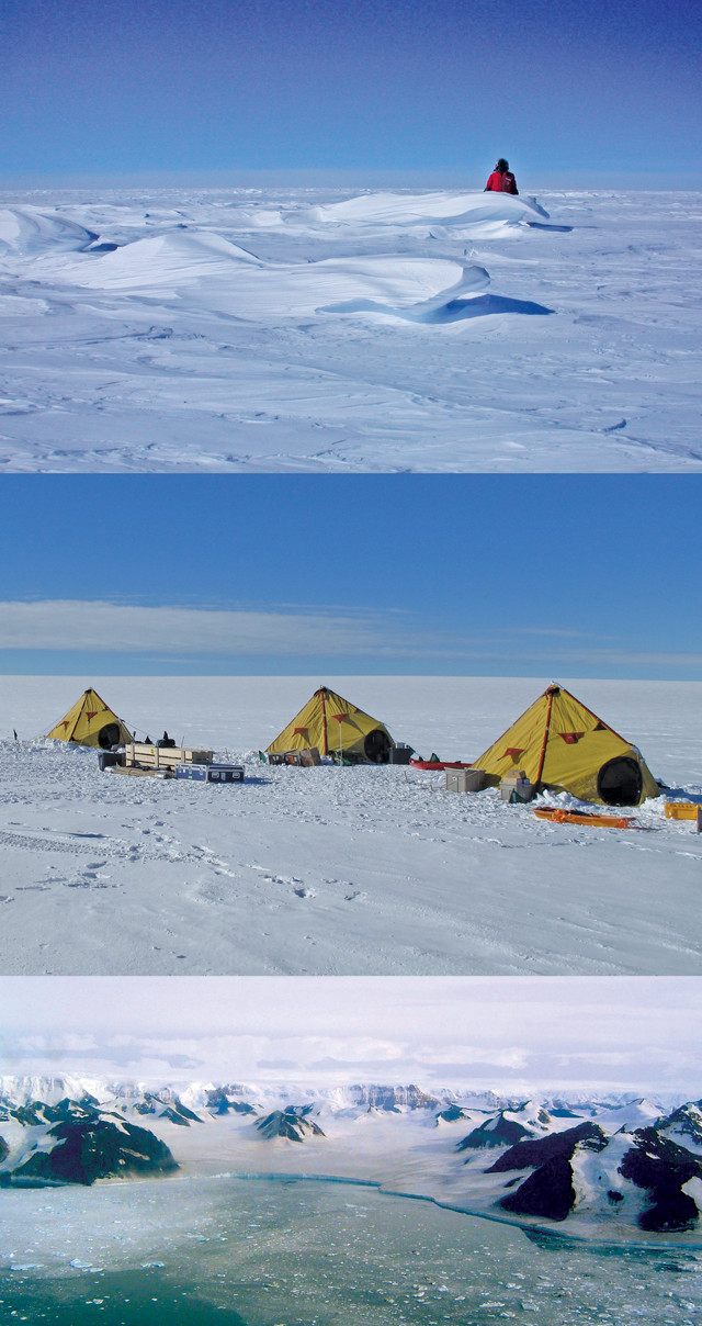
Scambos enjoys photographing his favorite fieldwork location: Antarctica. Credit: all: Ted Scambos, NSIDC, University of Colorado.
__TC: What options are being considered?
TS:__ It’s a real challenge to make long-term measurements in some of these areas, especially along the coast. If you are a desk-sized box of instruments, you really don’t want to hang around the coastline of Antarctica or Greenland. Huge blocks of ice — the size of buildings or even mountains — are being pushed around by winds, currents and tides. “Crushing” doesn’t really begin to describe it. Unless you can find a place to hide, you’re not going to last very long. There are ways of [hiding the instruments] by submerging the instrument package below the high-energy surface zone, or by using disposable instruments, which scares folks with budgets to worry about. Some researchers are also cleverly using animals as a platform for sensors. Although this approach has limits, scientists can get a massive amount of data this way, and the instruments have the potential to last for years because the animals know how to hide.
__TC: How do you install instruments on an animal?
TS:__ Elephant seals are good vehicles because they’re big, and they don’t seem to mind the instruments. You walk up to them and tranquilize them with a needle, then wait and make sure they’re asleep. Next, you shave a little patch of their forehead and glue on a little box — sort of like a Turkish cap — with some flexible adhesive. They don’t try to scrape it off, it doesn’t seem to affect their breeding success — even though they look ridiculous — and it stays attached for quite a while. Elephant seals dive quite deep [more than 1,500 meters], so instrumenting 10 or 20 of them provides hundreds of deep-ocean profiles over the course of a year. When the elephant seal pops up at the water’s surface, those data are radioed back to a satellite. You can see what the seals are doing in near real time, and you don’t have the additional cost of going back and recovering the data. Those repeat measurements are really valuable for understanding how the ocean evolves.
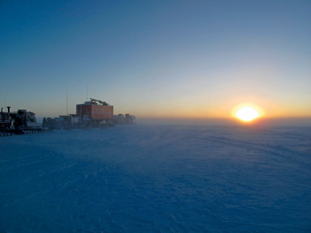
The sun circling the horizon during the Antarctic summer. Credit: Ted Scambos, NSIDC, University of Colorado.
__TC: What are these instruments measuring?
TS:__ Temperature, pressure and salinity. When you enter these data, along with background measurements, into a model, you get a pretty good idea of how the water is circulating, and what’s driving it. In both Antarctica and Greenland, there are warm mid-ocean layers about 400 to 2,000 meters deep that store a lot of heat. These layers have always been there, but because of surface-wind changes, more of this warm water is getting pushed up onto Antarctica’s continental shelf, which often slopes back toward the continent. Once the warm water gets over this lip, it flows [under the ice sheet] downhill to the grounding line, where the ice is coming afloat. This pulse of water is 2 or 3 degrees above freezing, which is a tremendous amount of heat when it comes to melting ice. Eventually, melting will cause the glacier to lose connection with part of the bedrock and lurch forward at a faster speed. This whole process is mostly invisible from space, so it’s a key place where we need to make in situ measurements to learn how ice sheets are evolving.
__TC: How do you prepare for fieldwork in Antarctica?
TS:__ There’s a big medical exam, so you have to maintain a basic level of fitness. But the main thing you’re doing is testing and packing gear to make sure that you’ve got enough familiarity with the instruments so that you can do your work once you’re there. There’s always a balance between the weight limitation and bringing enough equipment to get the job done.
__TC: Have you ever been in a life-threatening situation?
TS:__ I’ve been in conditions where if I hadn’t been careful, I could’ve gotten into big trouble. During one expedition, we drove downwind to make measurements. The wind picked up throughout the day, so on the way back we had a pretty stiff crosswind coming at us, and it was minus 30 degrees. By then we’d been out for several hours. My upwind leg got completely numb, so I was seriously worried about getting frostbite in my toes. For the entire 1.5-hour trip back, I was commanding my toes to clench and release, but I could no longer tell whether they were moving.
Whiteouts can also be tricky; I’ve had experiences where we’d set out flags every 500 meters, but later couldn’t see from one to the other. So I drove out until I saw the next flag and then signaled my partner that it was safe to follow. If I had become disoriented, or if it had started to snow heavily, we would’ve lost sight of everything.
I guess the other experience is just the cold itself. When the temperature gets to the minus 30s, with a wind or even just a steady breeze, there’s something instinctual going on in your head. You know at a gut level … it’s hard to describe … you know in your core that you can’t survive this for very long. That you’re losing. It takes a lot of will to stay out and keep going until you can get warm, eat and relax a bit. That’s why I mostly work in the warm areas now! Give me 25 Fahrenheit and sunny, thank you.
© 2008-2021. All rights reserved. Any copying, redistribution or retransmission of any of the contents of this service without the expressed written permission of the American Geosciences Institute is expressly prohibited. Click here for all copyright requests.