
by Terri Cook Tuesday, January 13, 2015
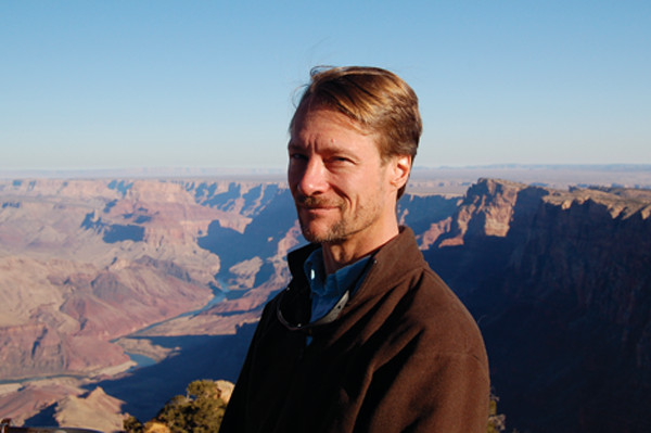
Gregory Tucker in the Grand Canyon. Credit: Courtesy of Gregory Tucker.
As an undergraduate anthropology student, Gregory Tucker thought math was a boring subject with abstract rules that didn’t relate to his life. Today, that “boring” subject provides the foundation for Tucker’s innovative research involving numerical modeling and unique field studies that recently earned him the European Geosciences Union’s 2012 Ralph Alger Bagnold Medal, one of the highest prizes in geomorphology.
Tucker’s work begins in his lab at the University of Colorado at Boulder, where he pioneered the use of two-dimensional landscape evolution models. His work continues in the field, where from the Rocky Mountains to western Taiwan to Italy’s Apennine Mountains, he has sought out informative case studies to ground truth his cutting-edge models.
In winning the medal, Tucker was cited for making critical contributions to many topics in geomorphology and for fundamentally advancing understanding of the way processes and landscapes interact to create landforms. Tucker recently spoke with EARTH contributor Terri Cook about his somewhat meandering career path through jobs in contract archaeology and at start-ups on his way to geomorphology, his sources of inspiration, and how he hopes his work may contribute to hazard mitigation.
TC: How did you progress from being an undergraduate studying anthropology to a quantitative geomorphologist?
GT: It was a slow process; I really had no idea what I wanted to do. I was interested in anthropology partly because of reading [the works of anthropologist and author] Carlos Castaneda as a teenager and then seeing the “Indiana Jones” movies. I had this feeling that if I didn’t have a career that forced me to get out and see the world, I was just going to sit at home and go stale, and anthropology seemed exciting. Then I went to a field school and found I was actually more interested in the physical landscape and the terrain than I was in the stones and bones that we were digging up. The kind of layers in the landscape and the stories they told seemed much richer and more interesting to me.
Another thread was that I’d always been interested in computers. But I thought that if I allowed myself to go too far down that road, I would really never get out. So I set that aside.
[Eventually] I realized that I wanted something that uses some of this computer stuff that also deals with nature and the landscape. That path led to geology. So I went to graduate school, where I realized why this is actually interesting and cool. And now I do a lot of mathematical modeling.
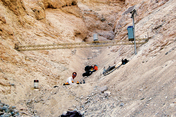
Tucker's research has taken him around the world, but most recently he's spent a lot of time studying debris flows close to home at Colorado's Chalk Cliffs. Credit: Courtesy of Gregory Tucker.
TC: What exactly is geomorphology, and how do you see it fitting into the geological sciences more broadly?
GT: Geomorphology has to be one of the most fascinating sciences that no one has ever heard of. It’s really the science that deals with understanding the shape of Earth’s surface and the way that shape changes in response to weather, climate, things that people do, and tectonic processes like earthquakes.
Geomorphologists work on a huge range of questions, from how to restore a river that’s been damaged back to its natural state, to predicting where landslides are going to occur, to determining what’s going to happen if all the trees in a particular place are cut down. We also deal with more [over-arching] things like why these mountains are here, how fast they are changing, and why they look the way they look.
TC: What led you to develop your own models?
GT: There’s something about the process of being able to reproduce nature using your own mechanistic hypotheses that’s exciting and fun. Geology is a very dynamic science, and those of us who work in it appreciate that it’s about change and movement. As geologists, we often have to use our imagination to see the dynamics because either we’re not there when it happens — when the landslide falls or the river floods — or because it happens so slowly that it’s difficult to witness.
For me, one of the fascinating things about computer modeling is that it gives me the next best thing to seeing it happen. It allows me to recreate a story. Some of the most fun moments for me in science have been when the process of building and running some calculation teaches me something that I hadn’t noticed before. Of course, people tend to be very satisfied when they create some kind of model to describe a phenomenon, and it matches. But it’s a lot more fun when the model doesn’t work, because that’s when I really learn something.
TC: How have you applied your modeling to questions in geoarchaeology?
GT: A few years ago I got involved in an unusual project with [hydrologist and fluvial geomorphologist] Rafael Bras from MIT [now at Georgia Tech]. We were interested in whether it was possible to use models of landscape evolution to say something about how the changing landscape, especially in a river valley, might influence the archaeological record.
So we set up a computer simulation in which we had a river meandering back and forth and eroding, floods that would lay down layers of silt on the landscape, and randomly generated “villagers” who would leave behind artifacts. Some of those would get buried, some of them would stay on the surface, and some of them would erode away. And because we knew exactly how and where we had planted all these digital villagers, in the end we could sum up how much of the record was preserved and how much was lost, and how much of what was preserved would have been visible to shallow [archaeological] surveys.
The conclusion was that periods of time during which a river is particularly erosive would be underrepresented in the record. That’s important because, for example, in the U.S. Midwest, there have been documented case studies of river environments where there have been accelerated periods of erosion.
TC: What are some projects you’re working on and what are you learning from them?
GT: I’ll tell you about the Chalk Cliffs, where we’re studying debris flows: highly destructive, difficult-to-predict events that happen all the time in some landscapes — Southern California being one example and the mountains of Colorado being another. One of the things that makes debris flows difficult to study is that they’re highly dangerous; you don’t want to be anywhere near one when it happens. Another thing is that, unlike rivers, they don’t flow all the time.
The project started as an effort to understand how debris flows shape the landscape. Chalk Cliffs is a small area near Mt. Princeton in Colorado that happens to generate several debris flows a year, on average. We teamed up [with a group at the U.S. Geological Survey] to monitor what nature was doing. We put in this set of instruments that measures the thickness of the flows when they happen, then videotapes them, measures the rainfall, and measures the force exerted by rocks crashing along the bottom of the flow.
Our team designed a special sensor that can even measure the erosion of sediment by a debris flow. … When the debris flow erodes the sediment, the flow gets bigger, and when the flow gets bigger, it gets more dangerous, and yet nobody has a very good understanding of what leads a debris flow to pick up sediment. Our research shows that debris flows grow faster when the sediment beneath them is wet, and they tend to erode from the top down. It doesn’t suddenly collapse like a landslide, but it picks it up little by little as it goes — fast, but little by little.
TC: Could your work lead to improved warning systems?
GT: Ultimately, we hope it will lead to a better ability to gauge hazards. That’s still a long way off because we’re really just trying to understand the physics; it’s really basic research. One of the things that we [and others have] learned is that you don’t get a lot of warning. The lag between heavy rainfall and the triggering of a debris flow can be 10 minutes, and these things move at a good, comfortable jogging pace. On the other hand, they’re the kind of hazards that don’t occur everywhere, and the conditions that tend to be ripe for them are something we know a bit about. It’s the sort of hazard, where, a bit like earthquakes, an ounce of prevention is worth a pound of cure.
TC: How is your work relevant to society?
GT: I guess I’m kind of a romantic, but I feel that it’s an important contribution to society to discover and talk about how rich and amazing the universe is. Some of my great heroes are people like [famed astronomer and author] Carl Sagan and [science journalist] Timothy Ferris, who had a huge impact on me when I read their books about how absolutely incredible our universe is — how rich and fascinating and woven with patterns it is. I’ve always loved the idea that part of the role of a science teacher is to convey a little of that glimpse of awesomeness to students. I see scientists as contributing to society in part the way artists and musicians do — that we are communicating or sharing a beautiful thing.
TC: What do you see as your contribution to educating the next generation of earth scientists?
GT: I think the geosciences are really important to society because we live in a physical environment and we use resources. I’d like our geology graduates to be able to go out into the workforce in a way in which they’re not just punching numbers into a computer, but where they have some ability to explain and understand what goes on.
© 2008-2021. All rights reserved. Any copying, redistribution or retransmission of any of the contents of this service without the expressed written permission of the American Geosciences Institute is expressly prohibited. Click here for all copyright requests.