
by Harvey Leifert Tuesday, January 9, 2018
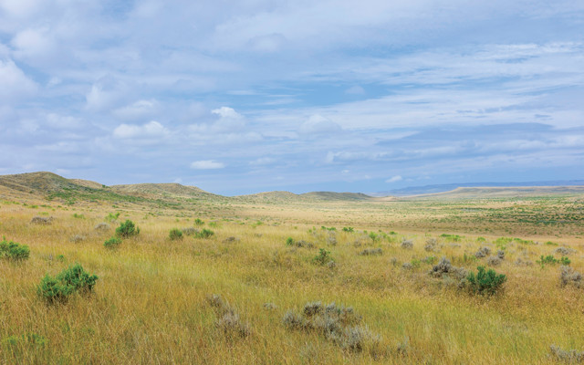
The Great Plains are well known for their sweeping grasslands, which, to the east, eventually turn into great farms, and, to the west, give way to deserts and mountains. Credit: ©iStockphoto.com/Danielrao.
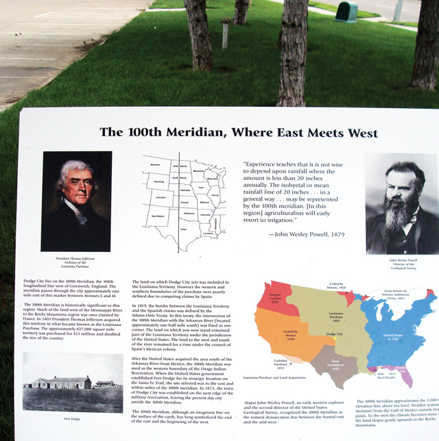
In 1878, without benefit of the Landsat program, GPS or Google, and just a decade after the creation of the National Weather Service, John Wesley Powell first advanced the idea that the climatic boundary between the United States’ humid East and arid West lay along a line “about midway in the Great Plains” — almost exactly 100 degrees longitude west of the prime meridian in Greenwich, England. This line, the 100th meridian, runs from pole to pole and cuts through six U.S. states, forming a partial boundary between Oklahoma and Texas. The 100th meridian also corresponds roughly to the 600-meter elevation contour as the land rises from the Great Plains toward the Rockies.
In his 1878 “Report on the Lands of the Arid Region of the United States,” Powell identified the “arid region” as the land west of the 51-centimeter-per-year rainfall line, which closely tracked the 100th meridian. This amount of rainfall per year is about the minimum that permits farming without irrigation, and it also greatly influences the types of crops that can be grown. The line Powell noted as dividing the arid and humid sections of the continent has become known as the “effective” 100th meridian.
Powell’s original goal in describing the effective 100th meridian as a dividing line was to persuade the federal government to bear in mind the greater aridity when planning for settlement and development in the western territories, which would be very different than in the moisture-rich east. He created a map that he presented to the House of Representatives in 1890, delineating western watersheds. He proposed that each one be designated a “commonwealth” for the purpose of regulating its water usage, which would remain under federal control without regard to state lines. Although Powell had by then been named second director of the U.S. Geological Survey, owing to his knowledge of the geological makeup of North America, he did not succeed with his proposal.
That same year, Powell sought a wider audience, since his original 1878 report to Congress had been largely ignored. In an article in Century Magazine, he vividly portrayed the semi-arid zone flanking the 100th meridian, which saw annual average rainfall drop from 61 centimeters on its eastern edge to 46 centimeters on its western edge. He described the effect of that change:
“On the east a luxuriant growth of grass is seen, and the gaudy flowers of the order Compositae make the prairie landscape beautiful. Passing westward, species after species of luxuriant grass and brilliant flowering plants disappear; the ground gradually becomes naked, with ‘bunch’ grasses here and there; now and then a thorny cactus is seen, and the yucca plant thrusts out its sharp bayonets. At the western margin of the zone the arid lands proper are reached.”
Powell was describing, of course, the naturally occurring vegetation one saw while traveling from east to west in the 19th century. During the 20th century, much of that vegetation was replaced with farmed crops; woodlands were cut down, and wetlands were drained.
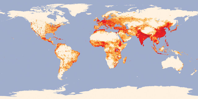
Researchers became interested in how the 100th meridian affected population after noticing a world map of population density on which two sharp lines stood out: one running east-west along Africa's semi-arid Sahel to the south of the Sahara Desert, and the other the 100th meridian through North America. Credit: image by Robert Simmon, NASA's Earth Observatory, based on data provided by the Socioeconomic Data and Applications Center, Columbia University.
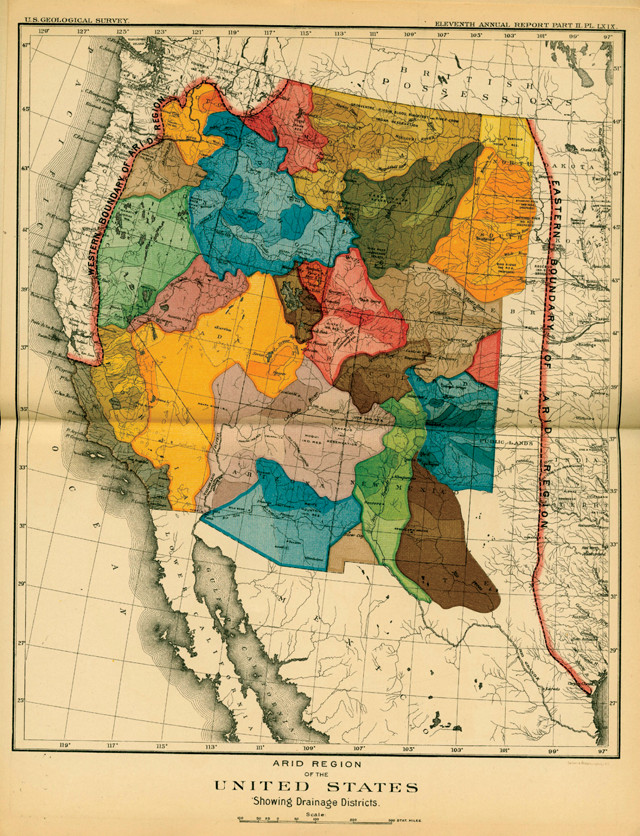
When John Wesley Powell first noted the dividing line between the humid East and the dry West as running along the 100th meridian, his goal was to persuade the federal government to bear in mind the West's aridity when planning for settlement and development in the western territories. He created this map delineating western watersheds in 1890, and proposed that each one be designated a "commonwealth" for the purpose of regulating its water usage, which would remain under federal control. Credit: U.S. Geological Survey.
“Today, the 100th meridian is still considered a climatic boundary line, but that will likely change in the coming decades: The 51-centimeter rainfall line is gradually moving east due to climate change, according to recent research.
In 2012, Richard Seager, a climate scientist at Columbia University’s Lamont-Doherty Earth Observatory (LDEO), became interested in the 100th meridian’s significance after chancing upon a world map of population density on which two sharp lines stood out: one running east-west along Africa’s semi-arid Sahel to the south of the Sahara Desert, and the other the 100th meridian through North America. Seager, along with fellow climate scientist Mingfang Ting of LDEO, began studying the geography and climate along the 100th meridian, enlisting the help of Nathan Lis, an undergraduate at Penn State, and Jamie Rose Feldman, an undergraduate at Columbia. They participated through the National Science Foundation’s Research Experiences for Undergraduates program. Feldman presented the team’s joint findings at the American Geophysical Union’s fall meeting in December 2016 and Lis presented at the American Meteorological Society’s meeting in January 2017. The work has been accepted for publication in the journal Earth Interactions.
In Powell’s time, like today, North America’s 100th meridian marked a steep drop-off in population density from east to west, Seager says. “That made me think,” he says, “that the arid-humid divide was reflected in the social and economic realm.” But how did this come about? “Did the changing environmental conditions going across the 100th meridian cause the change in population density and use of the land?” Seager asks. “Or, alternatively, did the characterization by Powell and others of the region west of the 100th meridian discourage people from moving west across the meridian, or influence public and private policy in a way that discouraged settlement west of the meridian?” He notes that, in the late 19th century, the federal government actively promoted settlement in the West, but the difficulty in obtaining insurance policies to farm there acted as a counterforce.
“Seager’s team wanted first to determine if the 100th meridian still aligns with the dry-humid boundary, or if this boundary had shifted away from the 100th at all. The researchers developed a standard measure called the aridity index to assess aridity across a geographic area, using observational data from the North American Land Data Assimilation System. They estimated potential evapotranspiration — the amount of water the atmosphere could potentially extract from the surface — from the land based on temperature, wind speed, solar radiation and relative humidity. The ratio of actual precipitation to potential evapotranspiration provides the aridity index.
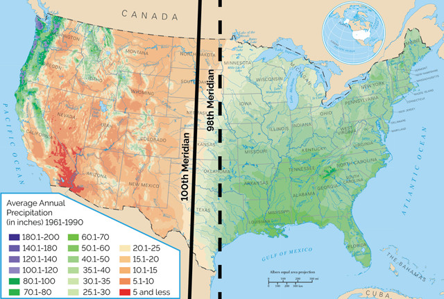
The 100th meridian runs from pole to pole, 100 degrees longitude west of the prime meridian in Greenwich, England. It cuts through six U.S. states, forming a partial boundary between Oklahoma and Texas. Powell identified this line as marking the point where the average annual rainfall dropped from 61 centimeters on the eastern edge to 46 centimeters at the western edge. New research shows a sharp aridity gradient still exists, but it's moved east a bit, closer to the 98th meridian. Climate models predict it will move farther eastward in coming decades. Credit: National Atlas, modified by K. Cantner, AGI.
“The researchers then calculated and plotted the aridity index across the U.S. from 1979 to 2016. They found that a sharp aridity gradient still exists, but that it’s now centered around the 98th meridian. “After examining the individual components that led to the gradient’s formation,” Lis says, “we determined that precipitation and relative humidity are the most significant contributors to the present gradient.” Those factors are in turn controlled by the rain shadow of the Rocky Mountains to the west (as Powell had surmised), as well as the flow of moisture from the Gulf of Mexico to the southeast.
Climate models project that the aridity gradient will move eastward by an additional two to three degrees by 2100, Lis says. That is due to expected increases in potential evapotranspiration driven by warming, rather than by decreases in precipitation, he adds.
The team next looked at potential impacts of the aridity boundary’s eastward march over the coming decades. They noted that aridity will likely increase at all longitudes across the Great Plains and that the existing gradient will weaken, blurring the boundary between east and west. This eastward shift in aridity will be most evident in the southern and central Plains, and less so in the north.
Both farming and water management will be affected by these changes in coming decades, the team noted. Traditionally, the researchers wrote, the Midwestern farm economy has reflected the east-west aridity gradient: the density of farms is highest between the 90th and 100th meridians at all latitudes, and uniformly lower west of the 100th meridian, where far more extensive irrigation is used.
This sign in Dodge City, Kan., marks the 100th meridian, which passes through the town. Credit: Shannon McGee, CC BY-SA 2.0.
The team suggests that as the aridity boundary, or the “effective 100th meridian,” moves east due to climate change, farms to the west of the shifting line will increase in size, especially in the south. That is because, in arid areas, farms must be larger to be profitable, Seager says. The Dust Bowl droughts of the 1930s led to larger farms amid the Great Plains for that reason, he says.
What farmers plant is also determined by the aridity of their land, the researchers note. At present, corn is the dominant crop in the east, especially in the northern Plains. There, it constitutes up to 70 percent of cropland, but to the west of the boundary, corn accounts for less than 20 percent of cropland, according to the researchers. Wheat, in contrast, covers about 40 percent of cropland west of the line but drops to less than 10 percent in the east. That is because wheat grows better in drier climates, whereas corn requires a warm, humid climate. (Southern Nebraska is an exception, Seager notes, in that corn is grown well west of the 100th meridian there due to extensive irrigation made possible by the Ogallala Aquifer.)
“All else being constant,” Seager says, as the effective 100th meridian encroaches eastward, farmers will likely shift from corn to wheat, or other less water-intensive crops, as corn yields decrease and become less profitable. However, he adds, in reality, “maize [corn] prices might increase and offset this.” In 2012, Seager notes, an economic modeling study by the U.S. Department of Agriculture (USDA) provided support for the idea that corn production will decrease, while wheat increases, in the newly arid areas. However, according to the USDA model, farmers in the transition area may end up adapting to the climate change by bringing more acreage of corn under cultivation to compensate for lower yields, rather than swapping corn for other crops.
Of course, other climatic factors — such as changes in El Niño-Southern Oscillation patterns, or the polar front jet stream — will also affect precipitation trends going forward.
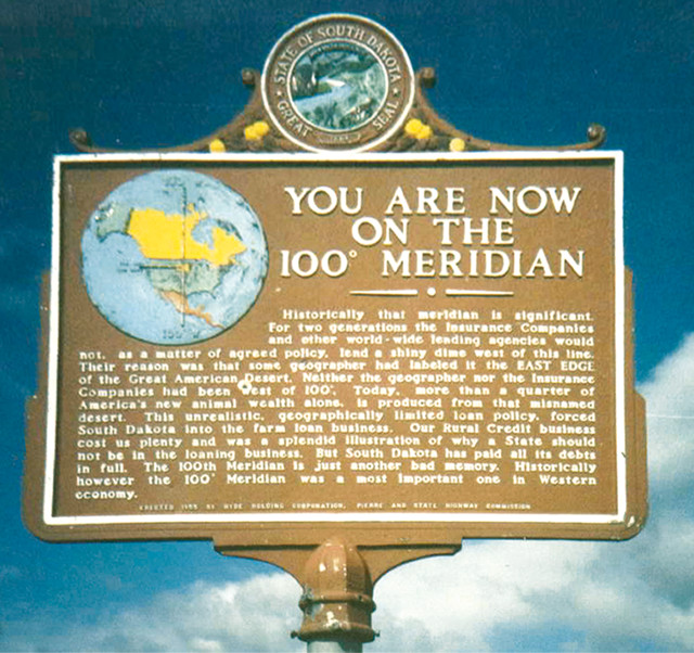
Some locations, including South Dakota, aren't thrilled with their association with the 100th meridian. This sign indicates why: People west of the line had trouble obtaining insurance and loans for farms. Credit: Robert Ashworth.
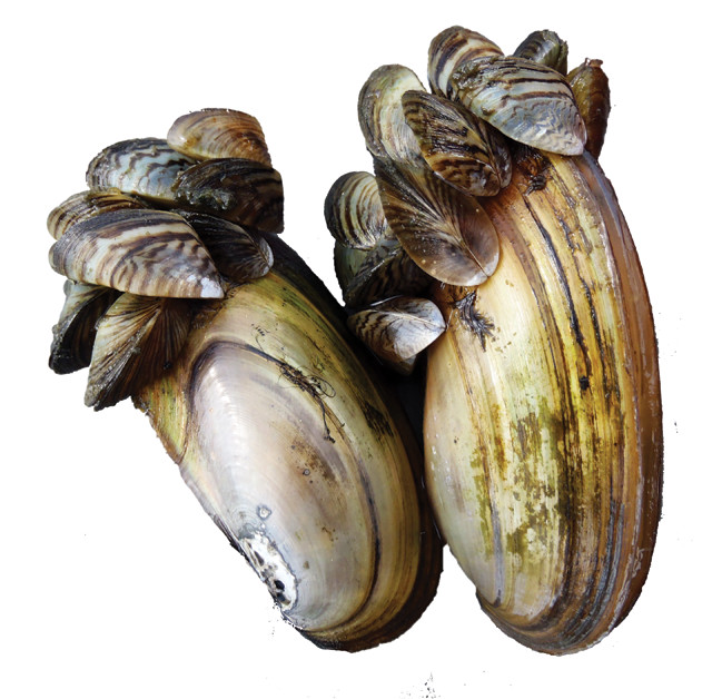
The 100th Meridian Initiative is a scientific project to prevent the spread of invasive species, like zebra mussels, from east to west. Zebra mussels can smother native mussels by covering the openings of their shells. Credit: Wisconsin Department of Natural Resources, CC BY-ND 2.0.
Since the demarcation of the 100th meridian was first observed by Powell 130 years ago, some states that straddle it have embraced their association with it, but others have disparaged it. A sign on ta border notes that the 100th meridian at that spot was originally part of the border between the Texas Republic and the Louisiana Purchase. South Dakota, however, hasn’t been so happy with its association. An official roadside marker erected in 1955 informs motorists that, “For two generationCompanies and other world-wide lending agencies would not, as a matter of agreed policy, lend a shiny dime west of this line. Their reason was that some geographer had labeled it the EAST EDGE of the Great American Desert. Neither the [unnamed] geographer nor the Insurance Companies had been west of 100 degrees.” The sign concludes: “The 100th Meridian is just another bad memory.”
Memory or not, the 100th meridian still demarcates certain dividing lines and continues to attract the attention of scientists, historians and even artists. The 100th Meridian Initiative, for example, is a project among local, state, provincial, regional and federal agencies to prevent the spread of invasive species, like zebra mussels, from the East to the West. And the 2014 book, “Dirt Meridian,” by Andrew Moore, includes stunning photos of the vast landscapes and hardworking people of the region.
© 2008-2021. All rights reserved. Any copying, redistribution or retransmission of any of the contents of this service without the expressed written permission of the American Geosciences Institute is expressly prohibited. Click here for all copyright requests.