
by Adityarup "Rup" Chakravorty Tuesday, April 18, 2017
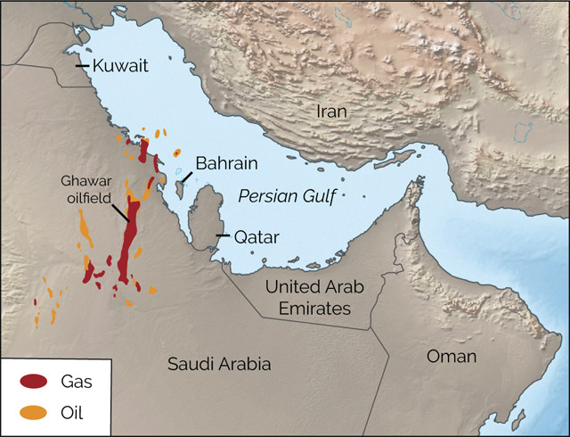
Rapid tectonic movements that shuttled the Arabian Plate from near the equator to the southern tropics and back again in the Middle and Late Jurassic may have led to the formation of Arabia's giant oilfields, including the massive Ghawar field. Credit: K. Cantner, AGI.
More than 6 percent of global oil production comes from a single oilfield: the supergiant Ghawar oilfield in eastern Saudi Arabia, which produces more than 5 million barrels of crude oil every day. In a new study in GSA Today exploring the origins of this vast oilfield, researchers have found that extensive tectonic plate movements during the Middle and Late Jurassic may have created the conditions necessary for the formation of the Ghawar and several other oilfields across the Middle East.
According to the study, the Arabian Plate, which was connected to Africa at that time, traveled quickly — tectonically speaking — from near the equator to the Southern Hemisphere tropics between 160 million and 145 million years ago. Then, it reversed direction and journeyed back north past the equator. This back-and-forth voyage meant that Arabia experienced very different climate conditions within about 50 million years, a relatively short period of geologic time.
In the mid-Jurassic, about 175 million to 160 million years ago, when Arabia was located near the equator, high levels of nutrients along the continental shelf led to the growth and burial of a lot of organic matter in offshore sedimentary basins. This organic matter would eventually turn into the oil and natural gas being extracted today.
“It’s relatively easy to account for the oil at Ghawar,” says Giovanni Muttoni, a geologist at the University of Milan and lead author of the new study. “The conundrum is in what lies above the oil” — evaporite rocks that cap and seal the abundant hydrocarbon deposits. Such rocks form in arid locations, where evaporation exceeds precipitation. “This stratigraphic evidence indicates that Arabia had to travel from moist equatorial regions to drier tropical areas within a few million years,” Muttoni says.
Based on reexaminations of previously reported paleomagnetic data, Muttoni and co-author Dennis Kent, a geologist at Rutgers University and Columbia University’s Lamont-Doherty Earth Observatory, proposed that Arabia’s journey into the southern tropics and back to its present latitude was part of a major global tectonic shift during the Jurassic. The shift “was a dramatic transition for the region, and it’s something that hasn’t been previously appreciated,” Muttoni says.
During sediment deposition and rock formation, some minerals, like magnetite, align according to orientation of Earth’s magnetic field at that time. Researchers can use this paleomagnetism to calculate the latitude at which the rocks formed, and by examining the magnetic record in different stratigraphic layers, they can piece together the travels of tectonic plates through geologic time relative to other plates and to Earth’s paleomagnetic poles.
Paleomagnetic data are not always totally reliable, however, “so we had to be very cautious” in reanalyzing the older data, Muttoni says. “As sediments compact, the original angle in which magnetic materials were aligned may be altered.” To avoid erroneous calculations, Muttoni and Kent used statistical compensations to correct for potential biases in the data, and preferred paleomagnetic data from igneous rocks, which are not subject to the compaction issue.
“Our calculations show a dramatic change in latitude for Arabia during the Middle and Late Jurassic, which matches the stratigraphic evidence at Ghawar,” Muttoni says. The researchers also linked Jurassic tectonic movement and stratigraphy at two other locations: the Neuquén Basin in Central Argentina and the Gulf of Mexico off the Texas coast.
“The correlation of the plate motions to the deposition of organic-rich source rocks [near the equator] and the deposition of effective seal rock at the tropical arid zones is intriguing,” says Rasoul Sorkhabi, a geologist at the University of Utah who was not part of the study. “But the authors give three examples only, and it will be interesting to see how well this perspective works when we consider other basins and petroleum systems,” he says.
“Local factors are quite important too” in the formation of oil deposits, Sorkhabi adds. “Petroleum systems … are far smaller in scale than those of tectonic plates. Therefore, while the plate tectonic scenario and perspective that the authors offer have merits, petroleum geologists still need to consider more detailed basin evolution and geology” to understand the origins of such systems, he says.
Muttoni agrees that local factors may have played a role in the formation of Ghawar and other oilfields. However, he says, “we don’t have much evidence on how local factors such as topography or orography contributed to these oilfields, but we do have evidence of plate motion.”
© 2008-2021. All rights reserved. Any copying, redistribution or retransmission of any of the contents of this service without the expressed written permission of the American Geosciences Institute is expressly prohibited. Click here for all copyright requests.