
by Mary Caperton Morton Tuesday, August 15, 2017
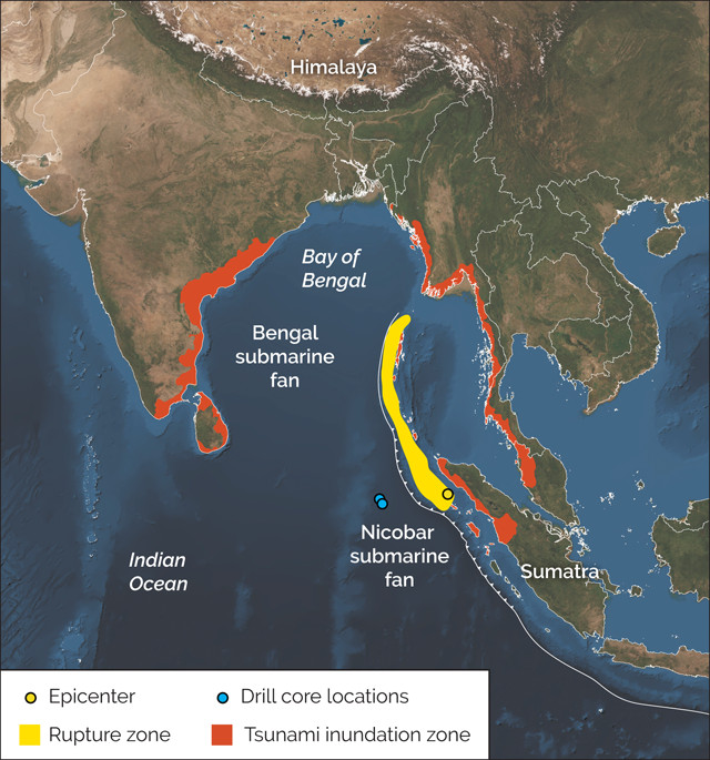
Map showing the rupture zone of the magnitude-9.1 Sumatra quake in December 2004, as well as the tsunami inundation zone and locations where scientists pulled up sediment cores that are adding to the understanding of the massive quake. Credit: K. Cantner, AGI.
Subduction zones are notorious for unleashing great earthquakes and tsunamis, such as the 2004 magnitude-9.1 Sumatra quake that caused shaking and inundations that killed more than 250,000 people and left millions more homeless. However, despite the dangerous reputations of subduction zones, their hazards are still often underestimated. New research reveals how sediments in the Sumatra Trench may have contributed to producing an even bigger earthquake and tsunami than hazard forecasts had estimated.
The Sumatra Trench is unique among subduction zones as it lies downslope from the Himalayan Mountains and the Tibetan Plateau. For millions of years, sediments shed from the highest mountains on Earth have accumulated along the subduction zone in piles more than 4 kilometers thick. “The sediment completely fills the trench,” says Sean Gulick, a marine geophysicist at the University of Texas at Austin who was not involved in the new study. “The sediments at the bottom have been buried long enough and deep enough that they aren’t unconsolidated sediments anymore — they’ve become sedimentary rock.”
To characterize these rocks, a team led by Brandon Dugan of the Colorado School of Mines used the research vessel JOIDES Resolution to drill sediment cores from the downgoing plate about 200 kilometers west of the subduction zone. “The ideal place to sample sediments would have been as close to the fault that slipped in 2004 as possible,” Dugan says, but the more than 4 kilometers of sediments in the trench “made that impossible.” Instead, the team moved 200 kilometers west of the trench to drill continuous cores through 1.5 kilometers of sediment and rock.
At a depth of 1.3 kilometers below the seafloor, the researchers encountered a strong layer about 80 meters thick. Analyses of the water contained in pore spaces between mineral grains in this layer revealed that freshwater had been added to the seawater, an indication that the sediments had undergone a process known as dehydration, in which water trapped within the crystal structure of minerals is forced out into the pore spaces between grains. “These dehydration reactions are controlled by increasing pressure and high temperatures,” Dugan says. Dehydration alters the minerals and consolidates the sediment into a strong, rigid layer. And as sediments pile up more and more, the overlying material applies increasing heat and pressure, gradually lithifying the sediments. This layer of rock the team found explains why the 2004 Sumatra quake was larger than models had predicted, the team wrote in Science.
Earthquakes propagate through rigid rock more efficiently than through sediment. “If you try to send energy through a pile of sand with a hammer, it just goes thud, but if you hit a rock with a hammer, it rings,” Gulick says. “An earthquake propagating through rock is much more likely to rupture dynamically and release large amounts of energy over a larger area.”
Sampling the sediments 200 kilometers west of the trench offered a unique snapshot of the process of dehydration in action, Dugan says. As the rocks are moved closer to the subduction zone, they will get stronger as the process of dehydration continues.
In most subduction zones, dehydration is thought to take place within the trench itself, but the extreme thickness of the Sumatran sediments enables dehydration to begin occurring before the plate reaches the trench and enters the subduction zone, Dugan says. This creates unusually strong material that allowed the fault to slip over a large area and at a shallower depth.
Thick sediments can also be found along a few other subduction zones around the world, including the Cascadia Subduction Zone off the west coast of North America, the Lesser Antilles in the Caribbean, and the Makran Subduction Zone off Iran and Pakistan, all of which may be capable of generating magnitude-9 or larger quakes. If the thick sediments are compacting to produce a hardened layer, the hazard potential of the subduction zone may be increased.
“Numerical simulations, seismic analysis and seafloor mapping can tell us a lot about these margins, but there is no substitute for drilling,” Dugan says. “The only way to ascertain the mineral composition and the chemical and physical properties of the rocks and sediments that make up the margin is by sampling directly.” That information may lead to more accurate hazard models, especially along margins such as Makran that don’t have a known earthquake history.
© 2008-2021. All rights reserved. Any copying, redistribution or retransmission of any of the contents of this service without the expressed written permission of the American Geosciences Institute is expressly prohibited. Click here for all copyright requests.