
by Kathryn Hansen Thursday, January 5, 2012
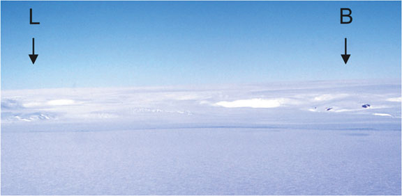
Rock outcrops - the Littlewood (L) and Bertrab (B) nunataks - protrude through the ice at Coats Land, a remote part of the Antarctic continent south of the Atlantic Ocean basin, and were once connected to the North American rift system. Courtesy of Ian Dalziel
Kathryn Hansen is an associate editor at EARTH and writes the CryoScoop blog. Lora Koenig
EARTH magazine bloggers already delve into natural hazards, paleontology, water and everything in between. Now each week I’ll be adding to EARTH’s blogosphere with weekly posts called CryoScoop, highlighting cool science related to Earth’s cryosphere.
My computer’s spell checking tool suggests that I change my word choice to “cry sphere,” so I suspect the actual term — cryosphere — could use a brief explanation. The cryosphere relates to the regions of Earth that support snow, ice or permafrost. That could include anything from a frozen lake in Michigan to a massive glacier in Greenland to perpetually frozen ground in Siberia. It’s a hot topic, as the impacts of climate change on Earth’s snow and ice are apparent right now, with potential impact on human communities and ecosystems around the planet.
It’s been a busy, news-making few weeks in the world of cryospheric science. Here’s the scoop.
Will Arctic sea ice stabilize? Maybe for a little while. A new modeling study published on Aug. 11, 2011, in Geophysical Research Letters showed that over short timescales (a decade or two), Arctic sea ice could see some years of stabilization or even expansion. In fact, under current climate conditions, the chance of Arctic sea ice expansion is just as likely as contraction over the next decade due to natural variations, such as wind patterns, that can influence the growth of sea ice. Still, continued warming in the Arctic would continue the longer term downward path toward eventual ice-free summers in 50 or 60 years, according to lead researcher Jennifer Kay of the National Center for Atmospheric Research.
In other research, experts are concerned that changes to the Arctic sea ice might cause walrus communities to migrate to shore en masse, reported LiveScience. The long-term decline of sea ice has reduced the amount of habitat over shallow-water feeding grounds. As a result, the animals have been seen migrating to land in larger numbers and to new areas, sometimes trampling each other.
At Earth’s other pole, scientists have found that the composition of lead isotopes from rocks in East Antarctica is identical to those from rocks in West Texas. The study, published in the September 2011 issue of the journal Geology, adds further support to the theory that North America was connected to Antarctica 1.1 billion years ago.
Scientists looking to better understand Antarctica in modern times have created the first complete map showing the velocity of the continent’s ice. The map, derived from satellite-based radar data, shows glaciers flowing thousands of kilometers from the continent's deep interior to its coast, according to NASA. The observations will help scientists understand how the ice sheets might respond to future climate change.
Finally, here are some of the week's coolest pictures.
The Petermann Ice Island-A, which formed when it calved from its namesake glacier in Greenland on Aug. 13, 2010, has finally grounded itself off the east coast of Newfoundland on Aug. 7, 2011. NASA’s MODIS instrument captured this image of the ice island on Aug. 14, 2011. Its companion ice island, B-a, is still adrift with a beacon attached. Follow it in real-time here.
Check out the before and after photos of the Sulzberger Ice Shelf following the Japan earthquake and resulting tsunami that occurred on March 11, 2011. Satellite data, analyzed by a NASA scientist and colleagues, show the direct impact of the tsunami, which broke away icebergs from the shelf, marking the first time such an impact has been observed.
Finally, click through the photo gallery of spectacular Arctic scenes compiled by the Associated Press.
© 2008-2021. All rights reserved. Any copying, redistribution or retransmission of any of the contents of this service without the expressed written permission of the American Geosciences Institute is expressly prohibited. Click here for all copyright requests.