
by Jane Palmer Thursday, February 15, 2018
The 850 residents of the peaceful rural village of Maca in the terraced hills of southern Peru are no strangers to disaster and drama. Sabancaya Volcano, which periodically explodes above their village, has been erupting regularly since late 2016, and earthquakes shake the region several times a year. The community’s existence has also been under threat from a less dramatic, but no less deadly, force of nature. Since the 1980s, some 60 million cubic meters of earth — more than seven times the size of the fatal 2014 Oso landslide in Washington — have been pushing through the outskirts of the town.
This large, slow-moving landslide sometimes moves as gradually as 10 centimeters a year, but after an earthquake or heavy rainfall it can speed up, reaching speeds as high as 7 meters a year. The landmass threatens the village, the surrounding farmlands, pre-Inca terraces, and tourism in the region — so much so that, in 2013, the regional government of Arequipa pressed for the relocation of Maca’s residents. “When you go into the field and you see the effect of this slow-moving landslide on the way the inhabitants live, it makes you realize that it is a very important matter,” says Pascal Lacroix, a geoscientist based in Grenoble, France, at the Research Institute for Development (IRD).
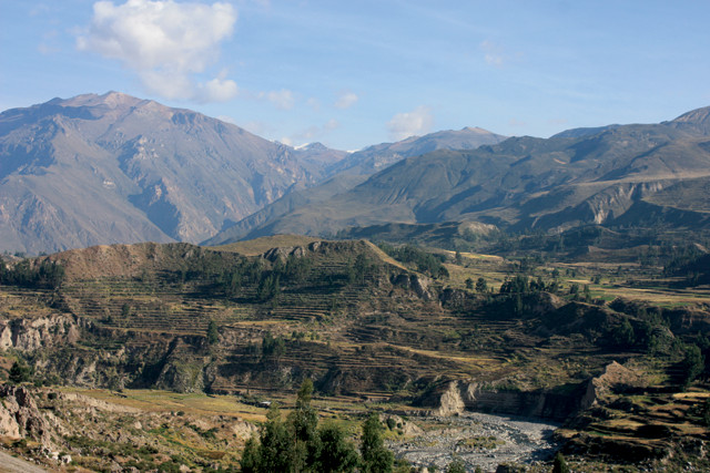
The Colca River carves a twisting path amid terraces that have been farmed since before the Inca lived there. The moving land has caused cracks in the fields that render centuries-old irrigation channels useless. Credit: Jane Palmer.
Starting in 2001, scientists have installed instruments on the landslide to record its movement, with the ultimate goal of providing an early warning system for when the landslide starts to speed up due to excessive rainfall or seismic activity. As well as improving the ability to detect surges in movement, this instrumentation offers scientists a unique opportunity to peer into the mechanics of how earthflows like the Maca landslide move and evolve, and to better understand how they are triggered to accelerate. Studying a landslide in slow motion allows researchers to develop hypotheses, test them repeatedly and witness landslide progression over time.
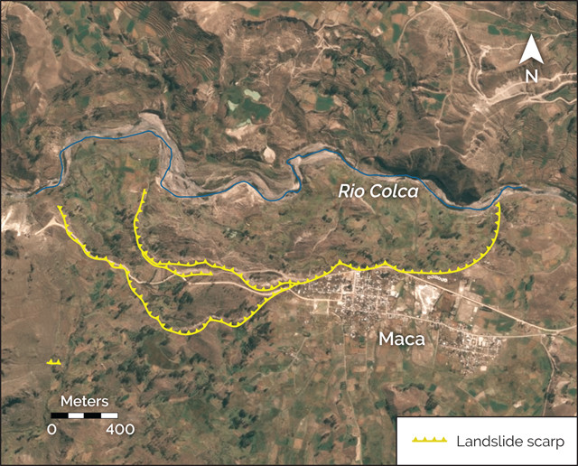
The Colca River passes to the north of Maca. Landslides are descending toward the river from the steep hills along both sides of the river, but the one on the outskirts of Maca is the most dangerous to the residents today. The slide has already wiped out parts of an old road into and out of town. Credit: K. Cantner, AGI.
Scientists have studied such creeping slides in Italy, Japan, New Zealand and the United States, but the Maca site presents the opportunity to tease apart the different impacts of rainfall and seismic shaking on the ground’s movement. In the Colca Valley, where Maca sits, rain falls fast and hard for four months of the year, and then rarely falls in the other eight months. “So we can measure the impacts of earthquakes alone, rainfall alone and, frequently, the two in conjunction,” Lacroix says. “It really is an ideal laboratory.”
Viewed from above via satellites, the Colca River carves a twisting path amid carefully farmed terraces, but as it passes to the north of Maca, the bows in the river’s course become more pronounced. In the early 1980s, a rapid landslide, the Lari landslide, descended the hillside above the riverbank opposite the town, pushing the river from its normal course toward the town of Maca. As the river followed its new diverted path, the flowing water swept away soil from the toe of the hillsides above, destabilizing the slopes and initiating the slow-moving Maca slide that continues today.
Thirty years on, the Maca slide is a complex beast. The full width of the landslide stretches 2.7 kilometers from east to west almost parallel to the course of the river. From head to toe it measures 1 kilometer. But rather than acting as a single earthen mass, the Maca slide is more like a family of minor landslides, each interacting with and impacting the motion of the others. The main factor that drives the downhill march of soil and rock is the roughly 50 centimeters of rainfall that typically occurs from January to April in the Colca Valley. Precipitation percolates into the soil and increases pore pressure, effectively lubricating the material and allowing it to flow more easily. Once the rains start, the land starts to move. It quickly reaches a threshold, beyond which only small increases in the groundwater level can cause large increases in the landslide’s velocity. The landslide can move during the dry season as well, although this motion tends to be barely perceptible.
At Maca, the connection between rainfall and earth movement is made more complicated by the region’s frequent earthquakes. The Colca Valley experiences several earthquakes a year; most are minor, but since the 1990s, more than 15 earthquakes above magnitude-5 have hit near Maca. In 1991, for example, a shallow magnitude-5.4 earthquake destroyed the western part of the village, killing 14 people and knocking down half of the town’s central building, the small white Iglesia Santa Ana. Most of the time, however, the residents, and their houses, have remained unharmed.
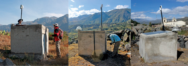
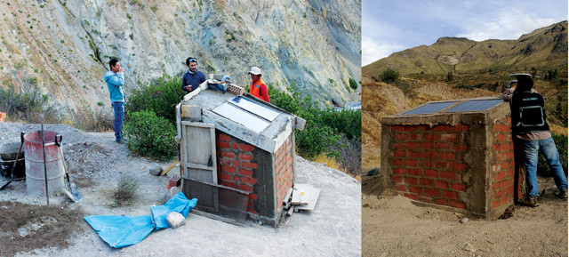
Starting in 2001, researchers began installing GPS instruments around Maca to monitor the landslide motion. Credit: left: Jane Palmer; middle and right: Pascal Lacroix.
Earthquakes, rainfall and river-induced erosion thus combine to influence this large earthen mass that moves slowly and intermittently downhill, to the detriment of the community. To the west of the village, fields of potatoes and corn lie atop the landslide, and, since it started moving in the late 1980s, small cracks have opened in some of these fields. As local water flows diverted into these cracks, farmers cultivating this land have been unable to continue using the ancient irrigation channels that have long watered their crops. Unable to keep the land productive, nearly a third of the town’s population has left in the last decade.
Recognizing that the landslide was posing a threat to the community, researchers from the Geophysical Institute of Peru installed temporary GPS instrumentation in 2001, 2002 and 2004 to monitor the movement of the earth. Then, as the impacts became more noticeable and concerns about the landslide speeding up grew, scientists from the IRD and Peru’s Mining and Metallurgical Geological Institute (INGEMMET) installed permanent GPS monitoring in late 2012.
“There are two objectives for monitoring,” Lacroix says. One is “the security of the people. [My Peruvian colleagues] want to monitor the landslide to give alerts to the inhabitants,” he says. And second is that “we, as scientists, want to monitor the landslides to understand the relationship between earthquakes and landslides.”
That earthquakes can cause fast-moving landslides is well established. The magnitude-7.1 earthquake that struck roughly 100 kilometers southeast of Mexico City in September 2017 triggered a spectacular landslide near El Jale in Ixtapaluca, and the 2016 Kaikoura earthquake in New Zealand resulted in landslides on nearby hillsides and along the coast. But the exact mechanisms by which earthquakes cause landslides, and how they might impact slow-moving landslides, remain unknown. At Maca, the permanent instrumentation could allow scientists to get a glimpse into what happens when an earthquake strikes, and to consider if the same triggering mechanisms cause both slow- and fast-moving landslides (see sidebar, page 30).
In July 2013, just months after scientists installed the continuous geodetic monitoring on the landslide, a magnitude-6 earthquake, with an epicenter less than 30 kilometers away, struck Maca. During the shaking, the instruments recorded that the landslide moved 2 centimeters, followed by an additional 6 centimeters over the next five weeks. Then it resumed its normal imperceptible rate of creep.
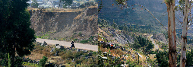
The nontraditional shape of the Maca slide has left many different scarps visible. Credit: both: Jane Palmer.
Scientists were intrigued about why the landslide had continued to move for weeks after the earthquake in the dry season and why it eventually slowed again to its background rate. Early models of the impacts of seismic shaking on landslides, such as one developed by engineer Nathan M. Newmark at the University of Illinois in 1965, suggested that movement should only take place during an earthquake, but the observations of the Maca slide demonstrated that this wasn’t always the case. To investigate further, Hugo Perfettini, a physicist at IRD, explored these questions using an alternative modeling approach. Perfettini had previously used a common model of friction, called “rate and state” friction, to investigate slip during seismic cycles — particularly post-seismic slip, or the creep of the land after an earthquake event — and he hypothesized that this same model would accurately capture the movement of the slow-moving Maca landslide.
“But when I tried to model the time series [from Maca] with my after-slip model, it didn’t work,” Perfettini says. He realized that a key tenet of the rate and state model — that only part of the landslide surface was slipping — did not apply in this scenario. In his next attempt, Perfettini approximated that the landslide moved entirely as a rigid block, which gave a better fit for the data.
In his updated model, once a landslide begins moving, independent of whether rainfall or seismic shocks trigger it, the frictional forces on the slipping surfaces of the landslide can either strengthen or weaken. Internal factors such as the material properties of the slipping surfaces and, for very deep landslides, external factors such as temperature and pressure ultimately determine whether the friction increases or decreases. While in some landslides these factors combine to weaken friction on the slipping surfaces and allow them to accelerate catastrophically after seismic shaking, in the case of Maca, the friction increases as it moves, so eventually the landslide slows down to its rate prior to the earthquake.
The 2013 earthquake highlighted the challenge of earthquakes in the Maca region, and the regional government of Arequipa asked INGEMMET to compile a report on the natural hazards facing the community. The IRD scientists assisted in the report, and after their assessment, the researchers stepped up monitoring efforts. Working with the Society of Exploration Geophysicists, the team increased the number of GPS instruments on the moving landmass and also installed three seismometers at the same sites to provide additional data related to earthquake impacts and landslide movement.
In August 2016, a magnitude-5.5 earthquake hit the Colca Valley, decimating the town of Ichupampa, 10 kilometers from Maca. When Lacroix inspected the GPS data from the Maca slide, he found that, on first glance, the movement during the 2016 earthquake appeared to mirror the findings from three years earlier: The seismicity sped up the landslide immediately and during the following weeks. This time, however, the scientists also observed that when the next rainy season came, in early 2017, and the landslide started moving, it did so faster than it typically would have moved at that time of year.
While waiting to publish the findings, Lacroix has theorized as to what is driving the landslide behavior during and after an earthquake. Seismic shocks can open up holes and cracks in the main body of a landslide, weakening its material strength and resistance to further movement, Lacroix says. The new fissures and cracks provide pathways for water to more rapidly infiltrate the landslide, so the earthquake damage to the Maca landslide leaves it prone to faster movement when the next rainfall comes, he says. “Even a small earthquake can create large effects on the landslide.”
Could it be that one day such shaking will weaken the landslide’s structure so much that its rate-strengthening friction could change to rate-weakening friction, and the landslide could accelerate catastrophically?
“This is a very interesting question,” Lacroix says. “Right now, we have no answer because of the sparse data on slow landslides in seismic environments, so we need to do more research.”
The researchers’ findings during and after the 2013 earthquake, and the initial observations after the 2016 earthquake, could have direct applicability in predicting the response of other landslides in the region, or even slow-moving landslides around the world. “Anything that helps to improve our understanding of rainfall, and the interactions among rainfall, groundwater and reactivation [of old slides] is [knowledge] that can be transferred to other big landslides of this type,” says Bill Murphy, a geoscientist at the University of Leeds in England. Images from the Pléiades Earth-observing satellites have revealed nine active, slow-moving landslides in the Colca Valley similar to the Maca slide. In particular, scientists have identified another large slow-moving landslide near the village of Madrigal that has also disrupted farmland.
The satellite images revealed that the Maca and Madrigal slides exhibit similar behavior in the rainy and dry seasons, and the findings from Maca could indicate the likely behavior of the Madrigal slide when earthquakes hit. In addition to creating fissures in local farmland, the Madrigal slide, if it accelerated, could have catastrophic implications: The large landmass could block the Colca River in a narrow part of the canyon and a dammed lake could quickly form. “If the dam then breached, it could create floods,” Lacroix says. “So this landslide poses a double hazard.” Aware of the possible implications of the landslide, researchers installed the first instrumentation on the Madrigal landslide in May 2017.
In May 2017, researchers installed GPS instrumentation on a landslide near the village of Madrigal, not far from the Maca slide. The Madrigal slide, in addition to creating fissures in local farmland, could have catastrophic implications if it were to accelerate. It could block the Colca River, creating a dammed lake that, were it to breach its dam, could cause severe flooding downstream. Credit: both: Pascal Lacroix.
The findings from the studies of the Maca slide also revealed similarities between the mechanics of slow-moving landslides and those of creeping tectonic faults. This discovery opens up the possibility of investigating the movement of landslides to learn more about the behavior of faults. “The earth doesn’t care what’s pushing it, it’s going to break in a similar manner,” says William Schulz of the Landslide Hazards Program at the U.S. Geological Survey in Golden, Colo. Landslides are easier to study than tectonic faults because of their smaller size, shallower characteristics and the fact that they move more steadily and frequently. “Landslides can be good intermediates between laboratory and fault scales,” Perfettini says.
Currently, Perfettini’s focus is on improving landslide models. “The ‘sliding block model’ of a landslide might be too limiting in the case of an earthflow, which behaves more like a plastic rather than rigid material,” Murphy says. Perfettini agrees, and says he plans to develop a more comprehensive model. Doing so, however, is no easy task.
“Unlike meteorology, where the equations of motion are known and the variables of the problem are known, in our field, we don’t even know the equations of motion and we are unable to measure the variables of the problem,” Perfettini says. Progress will depend on using modeling and laboratory findings and extrapolating them to the fault- or landslide-scale. But a serious scaling problem still exists. The scale of laboratory experiments is usually in the range of meters, but what scientists are trying to measure in the field is on the scale of kilometers or more.
The discoveries at Maca can lend valuable insights to questions about how earthquakes initiate fast-moving landslides or reactivate slow-moving ones, beyond what has been available with experimentation alone. Even with these data, however, it remains a complex challenge for scientists to unravel. “This is why the field is so exciting: It is a tough problem with a high socioeconomic impact,” Perfettini says.
Meanwhile, the villagers of Maca are less concerned about how best to mathematically describe the moving earth that is slowly inching across their fields and terraces, than about how to cope with its impacts. The idea of relocating to farmable lowlands — at the urging of regional authorities — is unpleasant for Maca’s remaining residents. Descendants of the Collaguas and Cabanas, pre-Incan ethnic communities who have lived in the region for some 2,000 years, they’ve perfected the art of keeping crops watered year round in the high and dry desert.
Their hopes for staying in their ancestral homeland lie with the scientists and engineers looking for ways to halt the landslide’s slow march, and Lacroix says there may be a means to curtail the creep. At the toe of the landslide, the Colca River twists and turns, taking out soil from the landslide base and leaving space for more earth to move downward. By building up banks of earth where the landslide meets the river, engineers could narrow the course of the river and prevent it from eroding the base of the slide. “If you just cut those meanders, it could slow down the [landslide’s] motion,” Lacroix says. Then again, he says, “for all we know, it could increase the speed of the landslide, or end up causing more landslides downstream. That is why we have to keep learning more about the landslide” — especially about its behavior in response to rainfall, earthquakes and the combination of the two.
© 2008-2021. All rights reserved. Any copying, redistribution or retransmission of any of the contents of this service without the expressed written permission of the American Geosciences Institute is expressly prohibited. Click here for all copyright requests.