
by Gretchen Miller Monday, July 24, 2017
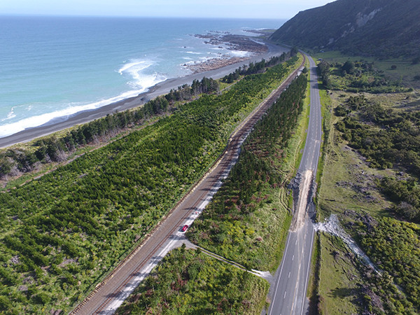
Papatea Fault, seen here where it crosses New Zealand's coastal State Highway 1 a little north of the town of Kaikoura, was one of the faults that ruptured during the magnitude-7.8 Kaikoura earthquake on Nov. 14, 2016. Credit: Julian Thomson
Just after midnight on Nov. 14, 2016, the northern end of New Zealand’s South Island was hit by a magnitude-7.8 earthquake. Epicentered about 60 kilometers southwest of the popular tourist town of Kaikoura, the quake was the strongest the area had seen since the 1855 magnitude-8.2 Wairarapa quake struck the Cook Strait. The Kaikoura quake led to two deaths as well as extensive damage to roads, rails and buildings.
Scientists investigating the earthquake, including Ian Hamling, a geophysicist at New Zealand-based research and consulting company GNS Science, who was awakened in Wellington that night by the nearly two minutes of shaking, soon realized the Kaikoura quake involved a chain reaction of ruptures on multiple faults.
“Nothing of this complexity with such good robust documentation has been documented before,” says Hamling, who analyzed the quake in a recent study in Science.
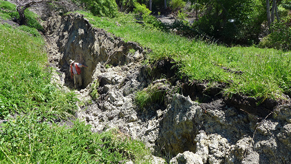
A geologist examines surface uplift along the Kekerengu Fault associated with the Kaikoura earthquake. Credit: Julian Thomson
Hamling and his colleagues used GPS and seismic data, as well as satellite-based InSAR measurements to study the rupture pattern during the event, finding that the earthquake propagated from north to south over 170 kilometers. Surface rupture occurred along at least 12 major faults — which varied in orientation and included two that were previously unknown — with displacements upwards of 10 meters on several. The ruptures also propagated between faults separated by 15 kilometers or more.
It was previously thought that gaps larger than about 5 kilometers between faults would prevent a rupture on one fault from triggering ruptures on other faults. The new findings challenge that conventional wisdom, and Hamling says New Zealand is already changing its seismic hazard modeling to include the possibility of multifault ruptures on faults separated by more than 5 kilometers. “Hopefully, we will get people talking, and also re-examine the paleoseismic record,” Hamling says. The record could reveal other examples of single earthquakes involving widely spaced faults, which could improve understanding of how a rupture can step across wide gaps. He says the former notion that a 5-kilometer gap would prevent the spread of ruptures between faults “is far too restrictive,” adding that allowing for triggering over greater distances will hopefully result in more accurate seismic models.
In the United States, the U.S. Geological Survey (USGS) and the Working Group on California Earthquake Probabilities (WGCEP) have been working on incorporating scenarios of multifault ruptures involving relatively distant faults into their hazard assessment models. “The Kaikoura earthquake could be the documented record holder for how far ruptures can jump,” says Ned Field, a geophysicist with the USGS in Golden, Colo., and leader of WGCEP, who was not involved with the new study. The comprehensive record of the Kaikoura earthquake compiled and analyzed by Hamling and his team, reinforced the WGCEP’s most recent hazard assessment, Uniform California Earthquake Rupture Forecast (UCERF3), Field says, which, for the first time, accounted for the jumping of complex ruptures between faults.
The WGCEP included multifault ruptures with gaps up to 5 kilometers in UCERF3, and may include multifault rupture systems with gaps up to 20 kilometers in their next rupture forecast, Field says. Such an update won’t necessarily affect California hazard models a great deal, he says. But, as the documented seismic record continues to grow, and geophysicists have more data from multifault earthquakes, earthquake rupture forecast models worldwide will become more comprehensive.
© 2008-2021. All rights reserved. Any copying, redistribution or retransmission of any of the contents of this service without the expressed written permission of the American Geosciences Institute is expressly prohibited. Click here for all copyright requests.