
by Linda Rowan Monday, January 5, 2015
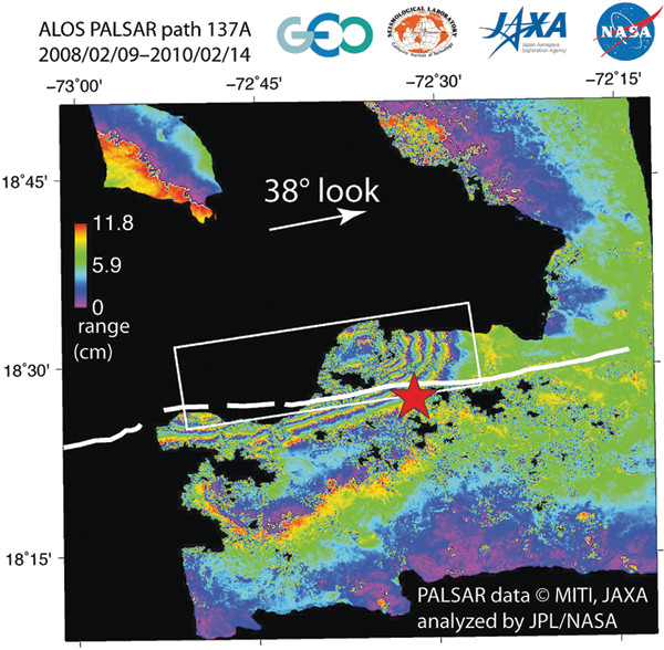
The Geohazard Supersites and Natural Laboratories initiative, a network of Earth-observing institutions, can designate certain natural disasters "event supersites" to help coordinate the collection and distribution of crucial data needed by first responders and scientists. Such data helped produce this map of surface deformation caused by the magnitude-7 earthquake in Haiti in January 2010. Credit: Eric Fielding/JPL/NASA/JAXA.
When major geologic hazards strike, they gain global attention. Disaster responders and scientists want remote sensing and in-situ observations of the site in order to respond faster and learn more about the event. Satellites operated by many countries as well as commercial entities provide eyes in the sky, while ground-based networks of seismic, geodetic, geochemical and other instrumentation keep ears to the ground. In the past decade, the United Nations has organized the Group on Earth Observations (GEO), a collaboration of 89 institutions and organizations that sustain comprehensive Earth-observing capabilities for the benefit of humankind. GEO has six global objectives, including the Geohazard Supersites and Natural Laboratories (GSNL) initiative. GSNL is a unique international collaboration focused on sharing spaceborne and other geophysical data to understand geohazards and to promote preparedness and hazard mitigation. GSNL has had several successes already and is poised for many more.
The two primary goals of GSNL are to acquire data for specific supersites and to build a cyber-infrastructure to integrate, archive and provide open access to data and data products. The European Space Agency provides a cloud-based archive of European satellite synthetic aperture radar (SAR) data, and UNAVCO maintains the GSNL data site and coordinates the Western North America InSAR Consortium. Supersites are single hazardous sites (such as one volcano) with ground-based observational infrastructure where shared spaceborne and other geophysical data would benefit research and hazards mitigation. Some of the most coordinated supersites include volcanoes and faults in Ecuador, Iceland, Italy, New Zealand and Turkey. In the future, some supersites or other regions will hopefully become natural laboratories, which are larger regions that encompass a coherent tectonic setting.
Hawaii was the first supersite and is an excellent example of the potential of GSNL. The island of Hawaii, where Kilauea Volcano has been erupting continuously from the East Rift Zone since 1983 and from the summit since 2008, is well instrumented on the ground, but researchers depend on the sharing of satellite data for remote sensing. Over the past decade, SAR data from multiple satellites have revealed insights into volcanic and seismic activity at Kilauea by tracking ground deformation and subsurface change related to magma dynamics, eruptions and earthquakes.
SAR images taken on different days are processed together to create interferometric images (InSAR), which show one-dimensional changes of Earth’s surface along the radar line of sight; this technique has been used extensively for geohazards monitoring. In June 2007, SAR captured a magmatic intrusion and eruption at Kilauea. Access to this data, facilitated by GSNL, helped researchers develop a technique that combines multiple aperture interferometry with InSAR to yield a 3-D image of surface deformation. Such data provided a fuller view of the ground motion associated with emplacement of a dike than was available from standard InSAR or ground-based data like GPS alone.
Another innovation, called SAR coherence mapping, can delineate a fresh lava flow based on the scattering properties of the surface. Fresh lava causes a radar signal to decorrelate in interferograms, allowing new flows to be distinguished from older lava flows.
SAR data from Kilauea acquired through the supersite have been used to identify instabilities along the rim of the eruptive vent at the volcano’s summit. Such instabilities may be indicators of the potential for hazardous rim collapses, which may endanger scientists or tourists near the crater. Because ground-based instrumentation cannot be installed near the vent rim due to ground instability there, SAR represents the primary tool available to measure ground deformation in the area.
GSNL has the ability to create “event supersites” when a geohazard strikes. The large and destructive earthquakes in Haiti (magnitude 7 in 2010) and in Tohoku (magnitude 9 in 2011) were rapidly approved as event supersites, in which space agencies, ground-based network operators and the scientific community were mobilized under very different scenarios.
Haiti had a very limited earthquake-monitoring network, and although instruments were rapidly deployed after the mainshock, satellite data provided critical information. These data are widely used. For example, within two months of the Haiti earthquake, 212 visitors (114 universities, 85 research institutions and 13 private-sector organizations) downloaded SAR data from a satellite operated by the Japan Aerospace Exploration Agency from the GSNL website. Remote sensing and ground-based data from multiple agencies provided information about the fault that ruptured, the amount and direction of surface deformation, the locations of landslides and liquefaction, and the continuing effects of the mainshock and thousands of aftershocks.
Most compellingly for society, the research showed that the earthquake occurred on a previously unmapped fault. The Enriquillo Fault — thought to be the main seismic hazard in the region — did not show much slip, meaning the potential for a large event on the island of Hispaniola, shared by Haiti and the Dominican Republic, remains high.
Japan already had a significant and sophisticated earthquake monitoring network, in addition to its own Earth-observing satellites. The Tohoku earthquake was a massive event that partially crippled some of the seismic network. The subsequent tsunami wreaked havoc on Japan’s complex infrastructure.
The International Charter on Space and Major Disasters initiated sharing of remote sensing data for response and rescue, while the GSNL members and many others worked with the shared data to understand the tectonic processes associated with the earthquake. During the first two weeks after the earthquake, about 4,500 visitors accessed the Tohoku event supersite and about 20,000 downloads of SAR images were recorded in the first month.
Even though the earthquake occurred offshore, where there is little in-situ monitoring, the combination of GPS and InSAR data allowed researchers to determine that the earthquake displaced some parts of the island of Honshu downward about 1.5 meters, eastward about 5 meters and southward about 2 meters. The direction and amount of deformation observed on the surface helped elucidate fault dynamics and provided insight into the likelihood of future earthquakes throughout Japan. Much was learned about the earthquake and tsunami, including lessons that can be applied to other major subduction zones, such as those in western North America, South America and Southeast Asia.
This global initiative represents an organized approach to hazards mitigation and preparedness that efficiently leverages a multitude of remote sensing and ground-based monitoring resources for science and society. GSNL is well on its way to fulfilling GEO’s mission “to realize a future wherein decisions and actions, for the benefit of humankind, are informed by coordinated, comprehensive and sustained Earth observations and information.”
Rowan is director of external affairs at UNAVCO, Inc., where she helps to advance geodetic-based research and geodetic data sharing for societal benefit in the U.S. and throughout the world. The views expressed are her own.
© 2008-2021. All rights reserved. Any copying, redistribution or retransmission of any of the contents of this service without the expressed written permission of the American Geosciences Institute is expressly prohibited. Click here for all copyright requests.