
by Natalia Deligne Monday, December 8, 2014
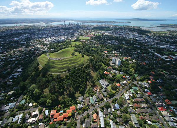
A view of Auckland, New Zealand, with Mount Eden in the foreground; at least 10 other volcanoes are also within the field of view of the photo. Credit: Kevin Snowden, ©Auckland Council.
Globally, one in 10 people live within 100 kilometers of a geologically “active” volcano — meaning one that has probably erupted in the last 10,000 years and will almost certainly erupt again. As I write this, homes in Pahoa, Hawaii, are being threatened by lava from Kilauea, and at least one home has been engulfed. The devastation that volcanic eruptions can leave behind, the huge uncertainties in what will happen next, and their often-prolonged timescales test communities’ resilience like few other events. Even the effects of distant volcanoes can be crippling: Volcanic ash can suspend air traffic, disrupt electrical transmission lines, require large areas to be cleaned up, and provide many other headaches.
However, like any other hazard, preparedness and planning go a long way in helping cope with fallout and manage the human response when eruptions do happen. Auckland, New Zealand, is working on just such a plan that can serve as an example to other cities facing potential volcanic hazards now or in the future.
Auckland, the country’s largest city with 1.4 million people — a third of the nation’s population — has a tricky volcanic problem: It sits right on top of the Auckland Volcanic Field (AVF). The field has more than 50 known vents, and the last eruption was only 550 years ago — “yesterday” by geologic standards.
Volcanic fields such as Auckland’s typically consist of dozens of small volcanoes, most of which, generally speaking, have only erupted once. This means the next eruption will most likely be in a new location. Another complication is that there are no obvious spatial or temporal trends among the past known eruptions offering hints as to the timing and location of future eruptions. Additionally, Auckland has received ash from central North Island volcanoes a few hundred kilometers away.
New Zealanders are no strangers to natural hazards; they are regularly faced with earthquakes, landslides, floods, tornadoes, tsunamis and volcanic eruptions. This steady exposure has encouraged the applied study of these natural hazards and their impacts for science-based planning (land use and emergency response) and policy measures.
Since 2008, there has been a concerted effort to understand and characterize Auckland’s volcanic hazards through the multi-agency, multidisciplinary research program Determining Volcanic Risk in Auckland (DEVORA). Since inception, DEVORA has emphasized the need for its research to result in applicable findings, actively promoting a direct link between science and hazard management.
DEVORA has a three-pronged approach focusing on: the why, developing the geologic framework for why the AVF exists; the what, characterizing typical and possible AVF hazards; and the consequences, the possible impacts of a future eruption. Earth scientists, engineers and social scientists have worked together on these questions, with regular input from municipal and national planners and decision-makers.
The scientific outputs of the program to date are impressive: seven masters and 11 doctoral projects have been at least partially supported by DEVORA, more than 180 presentations have been given at scientific conferences, and more than 80 papers have been accepted or published in a range of peer-reviewed scientific journals. Among the program’s many contributions to the field: The AVF is now known to be longer lived and more active than previously thought, with larger direct impact footprints than initially expected; our understanding of how the style of volcanic activity depends on underlying substrate rock and groundwater/sea content has deepened; and our sense of how long it might take to clean up ash from eruptions — estimated to be weeks to months — has been refined.
This rigorous scientific work needs to be made useful for those who are charged with preparing for and dealing with future eruptions. To this end, DEVORA is partnering with GNS Science (New Zealand’s geologic survey) and the New Zealand National Institute of Water and Atmospheric Research to adapt and use RiskScape, a multihazard tool under joint development by these two agencies for New Zealand natural hazard risk assessment.
RiskScape, which started being developed in 2004, breaks natural hazard risk assessment into manageable components. It applies a hazard model, such as the extent of a lava flow, to an asset layer, such as buildings, infrastructure and people; using a vulnerability function that quantifies how much damage a lava flow could cause to a building, for example, it then evaluates likely impacts. RiskScape’s modular structure allows users to explore the consequences of parameters they are interested in. For example, how much worse will things be if the ash is twice as thick? Does it make a difference if all the buildings are brought up to modern code? How many lives will be saved (or adversely impacted) if a particular zone is evacuated? What is the cost of damage if a lava flow inundates an area? RiskScape also allows users to explore the ramifications of various mitigation measures and policy.
Although RiskScape was conceived for New Zealand, it has been adapted for use in other locations. As long as data on hazard layers, assets and fragility functions that work for those assets — meaning, for example, how different buildings in different places would be affected, given that building materials and designs are vastly different from place to place — are available, RiskScape can be used anywhere.
As Auckland waits for the inevitable — a local volcanic eruption — it can rest assured that scientists, policymakers, land-use planners and emergency responders are all working together to prepare for this and other natural disasters no one ever wants in their backyard.
© 2008-2021. All rights reserved. Any copying, redistribution or retransmission of any of the contents of this service without the expressed written permission of the American Geosciences Institute is expressly prohibited. Click here for all copyright requests.