
by Lionel Jackson Thursday, November 8, 2018
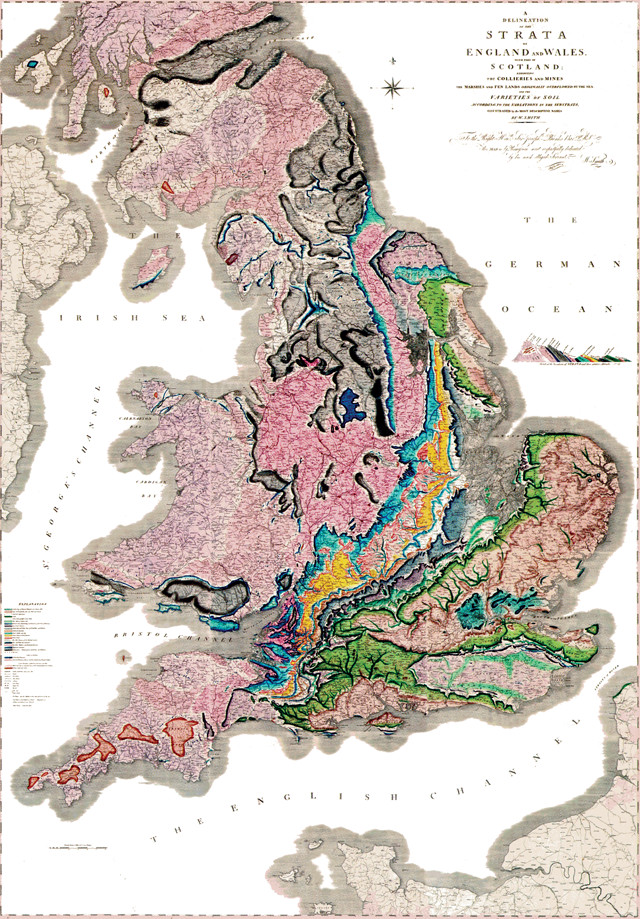
The most basic goal of national geological surveys is to map the geology of the country. This map, the first complete geological map of Britain, was published by William Smith in 1815, 20 years before the British Geological Survey — the world's first — was formed. Credit: William Smith, scan by the Library Foundation, Buffalo and Erie County Public Library.
The world’s oldest national geological survey is 183 years old; the youngest is 19. These two, and every other one out there, represent countries with vastly different needs — while some surveys are focused on overarching goals like natural resource sustainability, others are still working to map the fundamental geology of their lands. Yet there’s much that brings them together now and will continue to in the future.
Creating national geological surveys was one of the premier scientific endeavors of the 19th century. Systematic geological mapping and investigations of the geologic record under the auspices of such surveys were underpinnings of the emerging science of geology. These activities were also instrumental to the industrial revolution and economic expansion in Europe and North America. Since the creation of the first national survey, the British Geological Survey (BGS), in 1835, most countries have created their own. The basic roles of most surveys are to understand the solid earth and surficial deposits, and to inventory mineral and energy resources beneath land and the seabed of territorial waters. Some have also expanded their scope to encompass surface, groundwater and ecological resources.
But what is the future for these agencies? This was a topic of discussion at a symposium held as a part of the Resources for Future Generations 2018 meeting last June in Vancouver, British Columbia. Speakers at this symposium — called “The Changing Role of Geological Surveys” — primarily represented geological surveys from G-20 countries. The presentations underscored that the roles of geological surveys are largely dictated by political and geographic context.
The youngest national survey, the China Geological Survey (CGS), was re-founded in 1999 and serves the country with the world’s fourth-largest land area and the largest population. China is faced with the dichotomy of being simultaneously a developing country and a manufacturing superpower. CGS Chief Engineer Yan Guangsheng outlined the survey’s mission as nothing less than a fundamental and pioneering role in China’s social and economic development, including securing resources and energy supplies, preventing and mitigating disasters and alleviating poverty. CGS must deal with urban geology in the context of explosive development of dozens of megacities and economic zones and their requirements for materials, water, energy and below- and aboveground transportation, as well as evaluate and mitigate natural hazards endemic to such cities. Each of these megacities have or will have populations exceeding most of the world’s countries. Meanwhile, the survey is still systematically mapping China’s geology. Collecting geological information — especially in these megacities — on a scale and at a pace unfamiliar to geological surveys in the West is a necessity in China. This survey, perhaps more than any other, has its work cut out for it.
Several other countries’ surveys are likewise facing hazards and energy issues as their chief challenges. In Japan, the priorities are developing resilience to the many natural hazards the country confronts and exploring fossil fuel resources. Masahiko Makino, assistant director general of the Geological Survey of Japan (GSJ), who spoke at the symposium, reviewed extreme threats from geological hazards — particularly seismic and volcanic hazards posed in the Japanese archipelago. GSJ is pursuing detailed information about geological structures of active faults and volcanoes, as well as more accurate forecasting of these features’ future activity, as crucial components in disaster mitigation. In a country where most of the population is located on narrow coastal plains, urban geology, like in China, is a high priority. One new project is the publication of high-resolution three-dimensional geological maps of urban coastal areas that are easily usable. GSJ recently revised the map of Japan’s volcanoes, and the related volcano database, so that users can look up the characteristics of each volcano easily. In a different vein, Japan is actively pursuing methane hydrates beneath adjacent seas as a frontier source of domestic natural gas.
For Canada, with 6.6 percent of Earth’s land area and 7 million square kilometers of continental shelf, the Geological Survey of Canada’s (GSC) changing role can be summarized as “back to the future.” The GSC was established in 1842 to aid in developing a viable Canadian mineral industry by establishing the general geological base on which industry could plan more detailed investigations. Sustainable development of mineral and energy resources are still significant factors in Canada’s economy. Consequently, through the years, GSC has adhered closely to its original mission. Of the many projects tasked to GSC in the last decade, three of the biggest are related to basic and targeted geological mapping: a major seafloor-mapping program to delineate the outer limits of its continental shelf in the Atlantic and Arctic oceans for submission to the United Nations Convention on the Law of the Sea; geological mapping of Canada’s northern regions (40 percent of its landmass) to increase understanding of them and to further open these regions to natural resource exploration and support land-use planning; and targeted geoscience mapping and investigations using an ore-system approach to increase the effectiveness of mineral exploration.
Common to all geological surveys is the challenge of aiding their home countries, and assisting developing nations, in developing sustainability and resiliency in a changing world. At the symposium, John Ludden, executive director of BGS, set out a notional list of what geological surveys and geoscience in general should do now and in the future, with an emphasis on sustainability and global perspective. Sustainable development and decarbonizing the planet will require geoscientists to work across engineering and socioeconomic spheres, he noted. Global outreach from surveys to the developing world will aid in the provision of water, food and energy where they are most needed. In tandem, he said, earth science should have a role in reducing global inequalities, while supporting science, education and industry in developing nations. In the realm of natural hazards, he suggested that the future goal of surveys should be to transition from identifying risks to modeling, prediction and communication.
Not surprisingly, Germany’s Federal Institute for Geosciences and Natural Resources (BGR) and surveys from many other European countries, as well as Australia, echoed the British survey’s vision. Intriguingly, the BGR looks to the United Nations’ development goals for direction. At the U.N., as in Britain, sustainability is the key word. Development goals emphasize reliable and sustainable energy supplies; environmentally sound and sustainable mineral supplies; and resilient and sustainable infrastructure.
Many surveys see combating and adapting to climate change among their most important roles. Each survey’s approach to the issue may differ, though. Geoscience Australia, for example, in addition to continuing its traditional programs to apply science and technology to understand Earth for the benefit of Australians, is confronting a mandate imposed by the changing climate in this increasingly arid continent-nation: that Australian communities be more resilient to natural hazards and have secure water resources.
Another task common to all national geological surveys is to make the case to their respective cost-conscious governments of their value and importance to national economies and the well-being of citizens. With that comes the need to make information collected by the surveys readily available to the public in digital forms that can easily be used for many applications. Previously unimaginable amounts of data are now routinely collected and must be stored, analyzed and made accessible. As Suzette Kimball, former director of the U.S. Geological Survey, and Vic Labson, director of the Office of International Programs, said at the symposium: “Geological surveys will need to transform discoveries into information to address societally relevant issues and allow management decisions and policy to be informed by science.”
© 2008-2021. All rights reserved. Any copying, redistribution or retransmission of any of the contents of this service without the expressed written permission of the American Geosciences Institute is expressly prohibited. Click here for all copyright requests.