
by Jeffrey Mount Friday, February 10, 2017
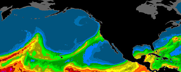
Atmospheric rivers are concentrated bands of water vapor that can stretch thousands of kilometers across the ocean, bringing tremendous amounts of moisture to the U.S. West Coast. Credit: NOAA ESRL.
December and January were very wet months in California, together landing in the top five of wettest two-month periods on record in Northern California. The abundant precipitation has restored soil moisture, refilled reservoirs and caused minor flooding. This is a big — and welcome — change from the past five years of record drought. Much of the improvement can be attributed to the return of atmospheric rivers flowing in from the Pacific: unique storms that are both a blessing and challenge for California water managers.
Atmospheric rivers (ARs) are narrow, concentrated bands of water vapor that form along the boundaries of contrasting air masses, generally in the eastern North Pacific. These bands, which can be several thousand kilometers long and a few hundred kilometers wide, transport prodigious amounts of moisture across the Pacific to the west coast of North America. When the rivers meet the coast, orographic lift over mountains, such as the Coast Ranges and Sierra Nevada in California, leads to intense precipitation, with rates equal to or greater than during hurricanes.
As much as half of the annual runoff in California comes from ARs, and most of this is associated with the roughly half-dozen large ARs that occur on average over a few months in winter. One type of AR called a “Pineapple Express” is typically the biggest rainmaker for California. In such storms, the narrow water vapor band taps into tropical or subtropical moisture near Hawaii. As of Feb. 10, California had already seen 13 ARs this winter, four of which were very large Pineapple Express storms.
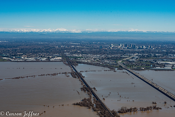
One flood management strategy in California's Sacramento Valley involves flooding farmland to spare housing developments, as shown here in late January following a series of atmospheric rivers. Credit: Carson Jeffers.
During Pineapple Expresses, the elevation of the rain-snow transition on land rises dramatically, often doubling from about 1.5 to 3 kilometers. This increases the land area receiving rain instead of snow. The high rates of rainfall, coupled with saturated soils, melting snowpack and steep terrain, translates to voluminous and rapid runoff of storm waters into mountain rivers and streams, quickly turning into floods in the valleys below.
For California, the difference between drought and wet is often tied to how many ARs make landfall in a winter. With a few extra ARs over the average, as is the case this year, surface water supplies are in good shape. Add in a large Pineapple Express and there may even be flooding. A couple fewer ARs in a given year, such as happened each of the past five years, and the state is in drought.
The tendency of ARs to deliver a lot of water all at once and over short periods of time poses a major challenge in a state that relies heavily on water storage in reservoirs.
California has more than 1,400 dams, which can store up to 40 million acre-feet of water in total — roughly equivalent to the state’s annual use for cities and farms. Most of this surface storage is behind large, multipurpose dams that supply water for domestic, agricultural and industrial uses, as well as provide water for hydropower generation, recreation, maintaining river ecosystems below dams and flood control. These purposes are often in conflict. To best prepare for large, pineapple express storms, and to protect floodplains downstream, flood managers prefer empty reservoirs to store runoff and dispense it slowly. Yet every other water interest prefers as full a reservoir as possible all year round.
The U.S. Army Corps of Engineers tries to strike a balance between these competing interests. Under congressional authorization, the corps sets reservoir operation rules that dictate how full the reservoir can be when flood risk is highest — typically December through February. If conditions allow — particularly in reservoirs fed by snowmelt — the volume reserved to hold floodwaters is replenished later in winter and spring as the probability of floods declines.
From a water supply perspective, the “flood reserve” can be an opportunity lost. To maintain flood reserve during winter, reservoir operators may release water that could otherwise be stored. And if there is limited snowpack and/or late winter rains don’t materialize, the reserve may not be filled, leaving the reservoir below capacity when the dry season arrives. This lost opportunity is compounded downstream where flood control levees reduce the ability to recharge the state’s aquifers.
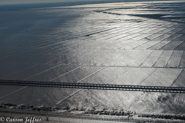
Flooded farmland outside of Sacramento, Calif., in late January 2017. Credit: Carson Jeffers.
Groundwater has long been California’s hedge against drought. In an average year, California relies on groundwater for roughly 30 percent of its water supply. In dry years, such as the last five, this reliance can exceed 60 percent. But the state has not been sustainably managing its groundwater resources.
California has been overdrafting its aquifers for decades. Annual overdraft — the average difference between what comes out of the ground and what goes back in — has been roughly 5 percent of annual water supply for at least the past 30 years. This deficit is causing land subsidence, harming aquifers and reducing the ability of groundwater basins to meet supply needs during drought.
In 2014, the state legislature passed the Sustainable Groundwater Management Act, requiring groundwater managers to balance input and output in their basins by 2040. Meeting the act’s requirements will require reduced pumping and, where possible, increased recharge starting within the next five years. Neither will be easy to accomplish, and given the state’s current floodwater management strategies, ARs are unlikely to bail them out. That’s because flood infrastructure below dams and on undammed rivers usually routes floodwaters away from floodplains, where groundwater recharge would occur.
Today, most groundwater recharge in rural areas, such as the Central Valley, comes by way of agricultural irrigation rather than infiltration of rainwater or floodwater. When ARs arrive and the rivers run full between the levees, there is limited capacity to move this water into aquifers. But views on this approach are stating to change.
New dam systems are one alternative, although their feasibility suffers from multiple challenges. To begin with, most of the logical dam sites are already in use. Dams also come with a wide range of environmental problems that make them difficult to permit. Perhaps most important, large dams are very expensive and rely on substantial federal or state subsidies to make their water cost-effective for users, particularly for agricultural irrigators who account for roughly 80 percent of water use.
The most promising alternative to large, multipurpose dams is to operate existing infrastructure differently. In this effort, it is important to manage surface waters and groundwater conjunctively. This means, in part, transferring water from reservoirs into groundwater whenever possible, which leaves more space in reservoirs to capture flood flows while reducing impacts on water supply. It also means promoting recharge of aquifers during wet years. In the Sacramento Valley, for example, flood bypasses channel floodwaters and spread them across farm fields to protect cities, which allows for recharge of local groundwater basins during floods. In the San Joaquin Valley — where groundwater basins are in severe overdraft — farmers are taking advantage of this wet winter and irrigating their dormant orchards and unplanted fields to recharge aquifers. And some water districts in the San Joaquin Valley are diverting water into settling basins to bank it in their aquifers. All of these approaches reduce the demand to store water in reservoirs.
It is also time to end our reliance on early-20th century approaches to reservoir operations. NOAA, in partnership with the U.S. Geological Survey and the U.S. Army Corps of Engineers, is experimenting with forecast-based operations, rather than using rule-based operations. Improved forecast models that better predict the timing, location and intensity of ARs can guide reservoir operations to better balance water supply needs and flood risk. So far, this work is experimental; the consequences of getting it wrong are significant, but it holds great promise.
These approaches — conjunctive management, increased groundwater recharge, and forecast-based operations — involve doing a better job with the infrastructure already in place, rather than creating complex, expensive and controversial new infrastructure. This is likely the most efficient way to adapt and take advantage of the occasional abundance of water from ARs.
© 2008-2021. All rights reserved. Any copying, redistribution or retransmission of any of the contents of this service without the expressed written permission of the American Geosciences Institute is expressly prohibited. Click here for all copyright requests.