
by Reginald L. Hermanns Monday, May 16, 2016
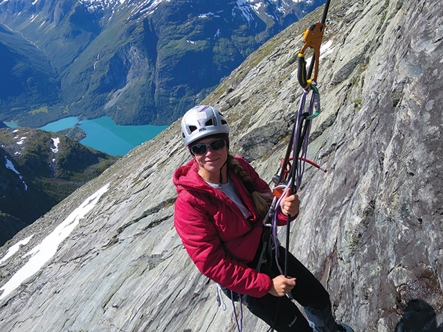
Florence Magnin is installing temperature loggers at 1,400 meters above Loen Lake on an unstable slope at Hoggrenningsnibba Mountain. In the background across the lake, a rockslide scar can be seen at Ramnefjellet Mountain; it is the failure surface of two previous rockslides that caused displacement waves in 1905 and 1936 (with maximum wave runups of 40.5 and 74.2 meters), which killed 61 and 74 people, respectively. Credit: Reginald L. Hermanns.
All high-latitude coastlines with pronounced relief are characteristically incised by deep fjords — carved by repeated glacial cycles — reaching far into the mountain landscapes. What is not characteristic of all of these coastlines is settlements, as these landscapes tend to be quite inhospitable, not to mention dangerous, thanks to the likelihood of rockslides. Norway, however, with thousands of people living on and visiting its fjordlands, is a different story. In recent years, Norway’s geological community has worked to reduce the risks posed by landslides to fjordland communities.
Norwegian fjordlands have been settled since at least the Bronze Age, with significant development occurring since the late 1950s, when oil was discovered on the Norwegian continental shelf. Whole communities sprang up as oil companies moved in and their workers’ grew prosperous along the fjords. In some localities along the coast, what were small villages only 70 years ago are now cities with large harbor facilities, airports, hotels, football stadiums and more. In addition, due to its natural beauty, Norway is a hot spot for European tourism. Fjords that boast only about 100 wintertime residents see tens of thousands of tourists per day in the summer. This sort of fast development, in such a setting, bears risks.
In the 20th century, three large rock avalanches dropped into Norwegian fjords or fjord-lakes, setting off displacement waves tens of meters high and killing dozens of people. Records dating back to the Vikings indicate that, on average, such disasters occur two to four times per century. If the fjords were undeveloped, this would be merely a geological curiosity. But the rapid development and increase in tourism have changed the risk. Today, the Norwegian Directorate for Civil Protection considers a rockslide disaster as the fourth-highest risk to Norwegian society, only topped by a pandemic, a long-term electrical grid failure or a strong earthquake in a city.
In Norway, individual communities are responsible for the safety of their populations, while the Norwegian Water Resources and Energy Directorate (NVE) is responsible for landslide and flood hazard mapping. The Geological Survey of Norway (NGU) has also undertaken mapping of large rock slope instabilities across the entire country, due to the complexity of geologic conditions favoring and triggering rock slope failures, and because displacement waves do not stop at municipality boundaries. The NGU mapping efforts start with the use of remote sensing data, especially satellite-based InSAR technology, which has helped reveal unstable rock slopes in high-mountain settings without vegetation, and lidar data, which helps in areas with thick vegetation.
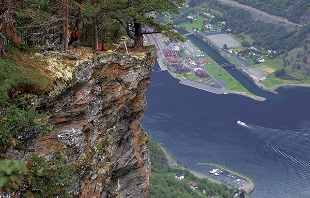
Geoscientists use ground-based lidar to measure deformation on the unstable rock slope of Stampa Mountain above the village of Flåm in Aurlandsfjord. More than 600,000 people visit this village each year. Credit: Reginald L. Hermanns.
Systematic mapping started in 2007, and in nine years, three and a half of the 17 counties with high relief have been fully mapped, revealing more than 250 unstable rock slopes. The counties with high relief are being mapped in high resolution. Last year, Norway decided it would image the entire country, not just the high relief areas, but at a lower resolution than in the high relief areas, relying on data from the Sentinel satellites, part of the European Space Agency’s Copernicus program: Each locality will be over-flown once every six days, allowing for near real-time observations all year long.
Once mapping reveals that slopes are unstable, the NGU uses a rigorous hazard and risk classification system on each slope to focus mitigation measures on medium- to high-risk sites, like unstable slopes that, upon collapse, could form rock avalanches that could crash into fjords and create displacement waves.
Mitigation measures include everything from draining rock slopes, which stabilizes them — a process that has been proven effective elsewhere, but which is extremely expensive and challenging due to many such sites only being reachable by helicopter — to emplacing continuous monitoring networks, including early warning networks. These installations — based on multiple instruments, such as tiltmeters, extension meters, microseismic networks and DGNSS (Differential Global Navigation Satellite System) stations — are also costly and challenging to build and maintain.
Draining slopes has been discussed in Norway, but no such projects exist yet. Norway’s prime mitigation measure involves emplacing early warning networks on all slopes deemed hazardous. Without such early warning networks, new development in the fjordlands would be impossible, since the building codes concerning landslide hazards in Norway are among the strictest in the world: Buildings without inhabitants must be constructed to withstand a landslide with a 1:100 probability of occurring in a given year, while single-family houses and condominiums must be built to withstand landslides with, respectively, 1:1,000 and 1:5,000 probabilities of occurring in a given year. (Probabilities of rock slope failure are estimated based on the hazard classification system, which considers factors such as the current rate of slope deformation, rockfall activity, and the cumulative amount of damage that the rock has accrued since the Scandinavian Ice Sheet receded 10,000 to 15,000 years ago.)
Because Norway’s building codes are so strict, a clause has been written in: If early warning can be given 72 hours ahead of time and all persons (including tourists) can be evacuated out of the hazard zone, then further development is allowed.
Today, more than 80 unstable slopes have monitoring installations for either ground-based or remote monitoring. The early warning systems are maintained by the NVE and are based on continuous-monitoring instruments installed both on the ground and in boreholes, as monitoring such hazard-prone sites cannot rely on one technique alone. In addition, backup systems exist for power supply and the telecommunication devices sending the monitoring data to the monitoring center. When these monitoring instruments detect even minute changes of motion within a slope, they send notes to the monitoring center, where experts decide, based on previously defined deformation rate thresholds, when to issue warnings to municipalities. Whether to evacuate is a decision left to the local authorities.
This year, the NGU is releasing a web-based map of all 250 unstable slopes known so far (to be found at www.ngu.no/en). The map will include relevant geological data on each slope, including the hazard potential for rock slope failures. At the same time, zones with building restrictions for all sites where the hazard and risk classification has been completed (22 of the 250 known unstable slopes) — and for which the hazard falls within the strict guidelines of the building codes — will become publicly available through NVE (to be found at http://atlas.nve.no/).
There is much work remaining, but this is a good start. The mapping project is expanding into other counties and eventually all the rest will be mapped. Meanwhile, the NGU is working on the hazard and risk classifications for all currently known unstable slopes, which involves monitoring these slopes for a couple of years since the classification is partially based on the deformation rate over time.
Norway’s mitigation strategy, relying largely on mapping and hazard and risk classification systems, combined with on-the-ground early warning networks, will not prevent the next rock slope failure or a potential displacement wave, but the hope is that our efforts will prevent future deaths when these slope failures do occur.
© 2008-2021. All rights reserved. Any copying, redistribution or retransmission of any of the contents of this service without the expressed written permission of the American Geosciences Institute is expressly prohibited. Click here for all copyright requests.