
by Zahra Hirji Thursday, January 5, 2012
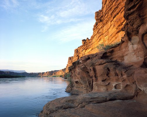
The 610-meter-deep canyons carved by the Colorado River (shown here) and other rivers give Utah's Canyonlands its name. Courtesy of National Park Service Photo
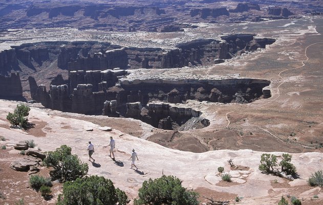
Grand Point is one of the most popular sites in the Island in the Sky district. Courtesy of National Park Service Photo
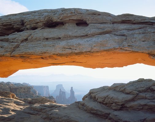
Mesa Arch is one of Canyonlands' smaller arches, but boasts beautiful views of the 180-meter-deep canyon below. Courtesy of National Park Service Photo
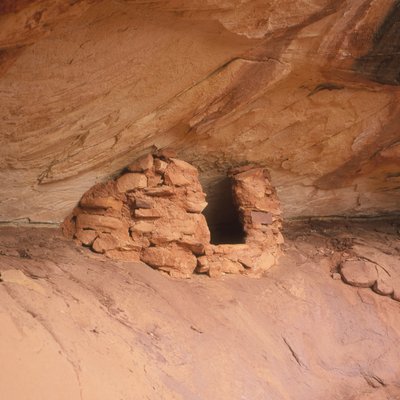
The Pueblo (or Anasazi) people settled in the Four Corners region, which includes southeastern Utah, two thousand years ago, leaving behind granaries (above) and dwellings. Courtesy of National Park Service Photo
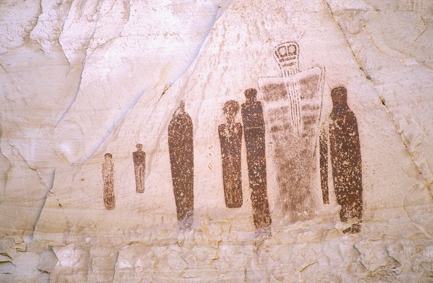
Rock art from ancient Native American communities is speckled across Canyonlands National Park. Courtesy of National Park Service Photo
Ditch the city for a week and enjoy the forgotten natural landscape of America at Canyonlands National Park, a haven for outdoor enthusiasts in southeastern Utah. Canyonlands offers ample opportunity to hike, camp, rock climb, drive, canoe, swim and much more, all while exploring a range of geological features in its three distinct districts: Island in the Sky, the Needles and the Maze.
The southwestern United States underwent millions of years of rock building and erosion before humans ever existed. Though the area is now arid and far from the sea, ancient oceans in the western and northern parts of what is now Utah repeatedly advanced eastward and retreated during the Triassic period (around 240 to 205 million years ago). When the oceans retreated, they left behind thick deposits of beach sands and marine limestones. To the east of the Colorado Plateau, compression formed the Rocky Mountains; to the west, the land stretched apart, forming the Basin and Range Province. But the Colorado Plateau itself, a geologic region containing the Canyonlands, remained structurally intact.
Then, approximately 10 million years ago, plates in the Earth’s crust moved, spurring a rise in the entire continent’s western edge, including the Colorado Plateau. The elevation increase led to the capture of more rain and snowfall, giving rise to the Colorado River system, and also prompted the river systems to cut deeper channels, pushing the water through the bedrock and resulting in roughly 610-meter-deep canyons. These canyons — twice the height of the Eiffel Tower — characterize the national park today.
The y-shaped cross-cutting pattern of the Colorado and Green rivers isolates the three districts from one another. Island in the Sky is at the northernmost part of the park, separated from the Maze, to the southwest, by the Green River. To the southeast, the Colorado River serves as a wall between Island in the Sky and the Needles. Both the Island in the Sky and the Needles districts have their own visitors' centers; the Maze has the Hans Flat Ranger station as a source for help and information.
If you are traveling by plane, you can land either in Grand Junction, Colo., or in Salt Lake City, Utah, which are two and four hours away, respectively, by car from the closest park entrance at Island in the Sky. The park has two paved entrances: Highway 313 takes you to Island in the Sky, whereas Highway 211 leads to the Needles. Getting to the Maze is more of a trek; the roads are comprised of graded dirt and often require four-wheel drive to pass. Be warned: These roads may become impassable when wet.
The most accessible district, Island in the Sky, is close to the town of Moab, Utah. The town caters to a range of travelers, from those in the mood for pampering at spas, luxury hotels and fine dining, to others more interested in doing their own grilling, camping and enjoying the nearby national parks.
Island offers opportunities to those interested in traveling by foot or car. Many of Island’s most prized features, such as Mesa Arch and Grand Point View, are accessible by car. Upheaval Dome, also accessible by car, is one of the coolest features in the Island district; the landmark is made up of an interior anticline or dome of pushed-up, folded rock and an exterior syncline of down-folding rock layers. Its allure is augmented by its mysterious geological origins. One theory claims the dome is a crater that resulted from a meteorite roughly 536 meters long in diameter (which equals roughly the distance of 5 football fields lined up length-wise for scale). A second theory postulates the dome is a pinched-off salt diapir (an intrusion of mobile, ductily-deformable material, in this case salt, that is forced into overlying brittle rocks). If the second theory is correct, this landmark is potentially Earth’s most deeply eroded salt structure.
Needles, located in the southeastern corner of the park, gets its name from the spires of Cedar Mesa sandstone, made up of red and white interchanging layers of rock. The white bands include salt blown into the region when the landscape was at the eastern edge of a shallow sea 245 million to 286 million years ago. The red layers derive from sediment loads carried in by streams. The Cedar Mesa sandstone built up over time until the uplift of the Colorado Plateau triggered the dramatic intrusion of water via river systems. Water carved the canyons, eroding and weathering the landscape by both flowing across the rock and into it via fractures and cracks — areas of weakness within the rock. Eventually, the fractures gave way to these needle formations.
In addition to the Needles’ majestic, picture-worthy geology, make sure to check out the lasting imprint of ancient Native Americans, also in the district. Wonderfully preserved prehistoric rock art can be found at Cave Spring and the Pueblo granary ruins, comprised of mud and stone, at Roadside Ruin Trail.
The most remote district, the Maze, is for the serious adventurists. The Maze is rather impenetrable by car, and when traveling by foot it is important to bring along a topographical map and GPS. While this district may be hard to access, the scenery makes up for it with breathtaking sights, including the Doll House, Maze Overlook, Golden Stairs and Orange Cliffs.
In the heartland of southeastern Utah, Canyonlands National Park offers a low-budget getaway that will keep you and the family entertained for days. This three-district park promises fun and breathtaking sites — whether for visitors interested in day excursions or scenic drives, or for travelers eager for a raw outdoor experience in Utah’s wilderness.
© 2008-2021. All rights reserved. Any copying, redistribution or retransmission of any of the contents of this service without the expressed written permission of the American Geosciences Institute is expressly prohibited. Click here for all copyright requests.