
by Meg Marquardt Thursday, January 5, 2012
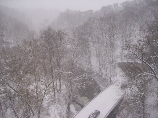
Duke Ellington Memorial Bridge in Washington, D.C., during a snowstorm in December 2009. Erin Wayman
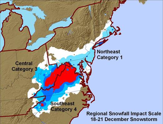
NOAA's snowstorm index ranked regional impact during a December 2009 snowstorm in the mid-Atlantic region. Within the region, there was greater impact (category 4) in the southeast than the northeast (category 1). Mike Squires, NOAA
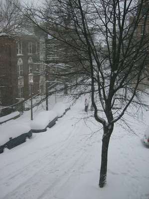
A December 2009 snowstorm dumped nearly two feet of snow on Washington, D.C. Erin Wayman
On Dec. 18, 2009, a winter storm deposited two feet of snow in a swath from the North Carolina mountains to Baltimore, Md., shutting down airports for days. Eight days later, a Christmas blizzard ripped through the Midwest, stranding holiday travelers in Nebraska and the Dakotas under almost a foot of snow. But which storm was worse? It’s a difficult call to make, because unlike other natural disasters, snowstorms have no categorization system. But researchers at NOAA are changing that: They are creating a unique ranking system to show how winter storms impact society.
Most natural hazards have concrete ranking systems. An earthquake is measured by a seismometer to get a specific magnitude. A hurricane with wind speeds of 125 miles per hour is a Category 3 storm. By this same logic, you might expect that a snow index would rely exclusively on the number of inches a storm produces. However, that doesn’t tell the whole story. To fully categorize a storm, NOAA’s proposed Regional Snowfall Impact Scale, or ReSIS, takes into account societal impact and relies on population density as well as the actual amount of snow.
“This index … will explain how serious a snowstorm was in terms of societal impacts,” says Mike Squires, a physical scientist and lead researcher on the index at NOAA’s National Climatic Data Center in Asheville, N.C. How many people a storm will affect is just as important as snow totals, he says. “It’s more than just ‘We had 18 inches of snow and it covered two states.’”
ReSIS depends on three quantities: the amount of snow in storm, the area affected by the storm and the population of the affected area. When values are entered for each factor — they are all weighted equally — researchers create a map of the storm, assigning a unique strength of 1 to 5 for each region the storm passes through. Because population density is taken into consideration, similarly sized storms can fall into different categories depending on where the snow falls. For example, a storm that drops seven inches of snow in a small, rural Virginia town will be a lower category than a storm that drops seven inches in Washington, D.C., and Baltimore.
At the moment, ReSIS is purely a historical look at snowstorm impacts and is not used for prediction purposes. But by knowing how other storms of similar predicted snowfall affected regions, meteorologists may be able to offer advice as to how to best respond to a new threat and how those highways, hospitals and schools will be affected. “It may give [meteorologists] a gauge of how much a storm will have an impact on society at large,” Squires says, and whether his categorization system is accurate.
Thus far, Squires has complied a database of the 200 most severe snowstorms nationwide since 1900. He draws the historical data from the Global Historical Climatology Network-Daily, another NOAA database that has firsthand measurements of snowfalls and temperatures from the 1800s to the present. As work progresses, more storms will be added to the ReSIS collection, painting a more robust picture of the type of snowstorms that trouble the nation.
“I think this is going to be a really powerful database to have,” says Gregory Dobson, a research associate at the University of North Carolina at Asheville’s Renaissance Computing Institute, which runs a database that holds a multitude of information about geographic regions, including the weather patterns, from which ReSIS pulls its data. “It’s really unique because it’s really the first good example of using this great GIS technology to assess weather in terms of societal impacts.”
“We can get to a point where we are better prepared for these kind of storms and hopefully lessen the impact of some snowfall, just like we would lessen impacts for hurricanes or tornadoes,” Dobson adds. “We can just be better prepared for the future.”
© 2008-2021. All rights reserved. Any copying, redistribution or retransmission of any of the contents of this service without the expressed written permission of the American Geosciences Institute is expressly prohibited. Click here for all copyright requests.