
by Timothy Oleson Monday, January 5, 2015
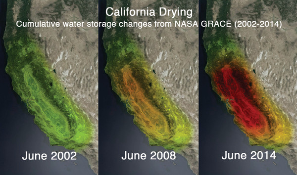
Credit: NASA/JPL-Caltech/University of California, Irvine.
Offering another perspective on the ongoing drought in the western U.S., NASA recently released this three-panel image illustrating relative water loss from California’s Central Valley between 2002 and 2014 based on data from the Gravity Recovery and Climate Experiment (GRACE) satellites (hot colors indicate greater loss). The contrast appears greater between the latter two panels, underscoring the substantial impact of recent conditions in California, where 80 percent of the state is facing “extreme” or “exceptional” drought (the two most severe of five drought levels) as of early December, according to the U.S. Drought Monitor. The Sacramento and San Joaquin river basins have lost a combined 15 cubic kilometers of water annually since 2011, partially due to groundwater pumping to sustain agriculture, according to a statement released by NASA.
© 2008-2021. All rights reserved. Any copying, redistribution or retransmission of any of the contents of this service without the expressed written permission of the American Geosciences Institute is expressly prohibited. Click here for all copyright requests.