
by Terri Cook Thursday, February 20, 2014
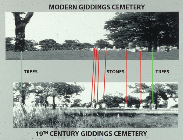
Comparing a historical photo of a cemetery in Giddings, Texas, to modern-day photos and removing modern additions like phone lines and curbing, Brooks Ellwood and his team noticed three trees and five monuments common in both photos, allowing them to locate the possible position of Wild Bill Longley's grave. Sure Ellwood
Ellwood, Smithsonian forensic anthropologist Doug Owsley and their team then excavated where the computer work indicated, and found the long-lost gravesite of Wild Bill. Sure Ellwood
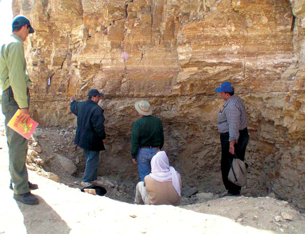
Ellwood pioneered the use of the MagnetoSusceptibility Event and Cyclostratigraphy (MSEC) technique to study Global Boundary Stratotype Section and Point (GSSP) localities around the world, such as this one near Luxor, Egypt. Brooks Ellwood
The call came out of the blue. Geophysicist Brooks Ellwood was sitting in his office in the geology department at the University of Texas at Arlington in 1990 when the telephone rang. On the other end was Doug Owsley, a forensic anthropologist at the Smithsonian Institution, who was calling to ask for Ellwood’s help to find the grave of “Wild Bill” Longley. Little did Ellwood realize that this seemingly straightforward request would set him off on a 10-year quest.
The search for Longley’s burial site is just one of the many unusual applications of magnetism that Ellwood has pursued in a career spanning more than four decades. During this time he has published one book in addition to more than 150 articles on topics ranging from air pollution to paleoclimate. He also uncovered the outlaw’s final burial place.
William Preston Longley was a notorious Texas outlaw rumored to have shot at least 32 people, topping even Billy the Kid’s purported tally. One of the first fast-draw, two-gun outlaws, Longley was known for his accuracy; it was said he could hit a small target six successive times from atop a moving horse.
Longley reportedly cheated death when he survived a hanging in Arkansas after a stray bullet severed the rope. Several years later, when he was convicted of shooting a boyhood friend and hanged on Oct. 11, 1878, rumors quickly spread that his death had been a hoax. Stories circulated that Longley had worn a special harness that prevented his neck from breaking, and had escaped again to become a rancher in Nicaragua; or that he had embarked as a passenger on the ill-fated RMS Lusitania, which was sunk by a German U-boat in May 1915 during World War I; or that he had moved to Louisiana’s Iberville Parish and raised a family under the alias of John Calhoun Brown.
It was the last of these that came to the attention of the researchers. One of Brown’s grandsons, after hearing of his possible ancestral connection to Longley, had approached Owsley to help him solve this historical mystery. After comparing photographs and handwriting samples from both John Calhoun Brown and Longley, Owsley concluded there was a chance that John Calhoun Brown and William Preston Longley had been the same person. The ultimate test would be to find Longley’s grave and expose either his remains or, as the grandson suspected, a rock-filled casket. This is where Ellwood’s experience — locating unmarked gravesites using sensitive geophysical techniques — came in handy.
“I’ve always tried to incorporate a practical laboratory into classes I teach,” Ellwood says. “It’s hard to get to mountains in Dallas, but cemeteries are great microenvironments” for testing and teaching students to use such equipment. In cemeteries, Ellwood and his students have conducted surveys using a custom-built proton magnetometer and electrical resistivity (ER) meter. As part of a study in south Dallas, for example, Ellwood and his students found several unmarked burials remaining in a graveyard thought to have been completely relocated.
Ellwood’s technique takes advantage of the expectation that gravesites should be overlain by anomalous magnetic variations. For example, a surface anomaly should result where iron is buried in a grave, and it would likely be oriented east-west, the preferred orientation of pioneer-era graves for religious reasons. Additionally, in places where the ground has been dug up, such as burial sites, the soil should have correspondingly higher porosity and moisture that reduces the ground’s resistance to electrical currents, resulting in low resistivity values (although in times of drought, differences in resistivity may become less apparent).
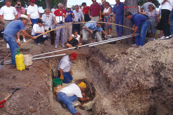
In the case of Longley’s grave, which various lines of historical evidence placed in a graveyard in the tiny town of Giddings, Texas, about an hour outside of Austin, the combined techniques worked well — almost too well. Despite magnetic interference from modern graves, which contain rebar, or steel reinforcements, plus the magnetic signatures of old metal fences and lightning strikes, Ellwood’s surveys in 1992 and 1994 located 61 geophysical anomalies he believed could be graves. After narrowing their range, the team excavated 31 unmarked burials, but none of the remains fit the description of the 6-foot-tall, 27-year-old outlaw.
Frustrated, the researchers returned to their last remaining clue: a historic photograph of Longley’s gravesite taken some 40 years after his purported death. One of the team members, Sue Ellwood, who is also Brooks’ wife, noticed that the area where they had been searching did not match up with the photograph. Using distinctive grave markers placed prior to 1925, as well as several old trees, Sue was able to take a modern photograph that matched the historic one. Using Photoshop, she removed modern additions such as phone lines and curbing. “Three trees and five headstones jumped out at us,” Ellwood says. They pinpointed a new site, received special permission from the mayor to excavate just one more grave and resumed their search in 1998.
As they dug, Ellwood became increasingly nervous. “All the burials we had seen before were about three, three and a half feet down, and we were already at four feet. I went up to the backhoe operator and told him I didn’t think it was there.” But the operator had a gut feeling, Ellwood says, and requested permission to dig a little deeper. “About 3 inches after that, coffin nails showed up, followed by the grave of what turned out to be a Caucasian male about 27 years old and just over 6 feet tall,” which matched Longley’s physique. Artifacts found with the skeleton also matched the descriptions of Longley’s clothing and ornamentation at the hanging. Ellwood was convinced that the team had finally found their man. He was right. A later test of DNA recovered from the corpse matched DNA from a blood sample given by the great-granddaughter of Longley’s sister.
Ellwood, now the Robey H. Clark Distinguished Professor of Geology and Geophysics at Louisiana State University, helped pioneer the use of magnetic susceptibility (MS) for high-resolution interpretation of sedimentary sequences around the world. Magnetic susceptibility is essentially how easily a material is magnetized in an inducing magnetic field, Ellwood says. A sample’s average bulk susceptibility can be determined quickly and is applicable to many geologic problems, he says.
For example, because changes in climate vary the amount of sediment flowing into the ocean, the magnetic susceptibility of sediments accumulating on the seafloor reveals information about past climates. During warm periods, erosion and rainfall increase, increasing the amount of material, including iron-bearing sediment, that makes its way to the ocean. During cool periods, precipitation and erosion slow and less sediment flows into the sea. Thus, in the rock record, high MS readings indicate warm climates and low MS readings indicate cold climates. Of course, these cycles are superimposed on long-term MS changes that are due to local and global tectonics and other factors, Ellwood says.
Climate processes also affect the magnetic properties of sediments that collect inside caves. MS measurements of sediments that have washed in and accumulated in caves can therefore also serve as a proxy for climate, opening the door to correlation between sites. Ellwood and others have used MS measurements of climate cycles to correlate Quaternary cave sites across Europe, and are currently extending these datasets into Southeast Asian cave sites.
The method has proved especially useful for dating archaeological sites more than 40,000 years old, which approach the limits of radiocarbon dating. Ellwood has, for example, used MS to pinpoint the important Middle–Upper Paleolithic transition that corresponds to the prehistoric Aurignacian culture, which archaeologists consider Europe’s first modern humans.
He applied the method to two caves in northern Spain — El Castillo and L’Arbreda — where Aurignacian cultural deposits were previously found but not precisely dated. Using what Ellwood calls the “time-depth-climate” signal, which can be extracted from MS data, his team concluded that the Aurignacian occupation began at the same time in both Spanish caves, and corresponded to a warm period about 40,000 years ago.
Using a similar approach at Scladina Cave, an important Late Pleistocene geoarchaeological site in Belgium, Ellwood determined the relative age of sediments associated with Neanderthal skeletal remains as 90,000 years old, plus or minus 7,000 years.
In the early 1800s, geologists began using fossils to help define boundaries on the geologic timescale. These scientists eventually realized that the appearance or disappearance of a fossil assemblage could be used to correlate rock strata of the same age deposited in widespread locations, a technique now known as biostratigraphy. With the development of chemostratigraphy in the 20th century, researchers began to take advantage of chemical techniques, such as variations in carbon isotopes or concentrations of elements such as iridium, to more closely correlate and, when possible, assign absolute ages to strata.
Ellwood and his collaborators have helped to develop the use of magnetostratigraphy susceptibility to attain even more precise resolution by combining MS measurements of Phanerozoic marine rocks with separate biostratigraphic controls to create what he calls the MagnetoSusceptibility Event and Cyclostratigraphy (MSEC) technique.
Ellwood has applied MSEC to the study of various Global Boundary Stratotype Section and Point (GSSP) localities. Sometimes called “golden spikes” after the bronze disks used to mark them, these internationally agreed-upon stratigraphic reference points define a stage boundary on the geological timescale — from Colorado to the Czech Republic to Morocco. After characterizing the MS of the materials spanning a GSSP, Ellwood uses these data to pinpoint where that same boundary lies in other stratigraphic sections crossing the same time interval. In this way, he can correlate sections at a higher resolution than using fossils alone.
In the late 1990s, Ellwood’s team was working on the Middle Devonian Eifelian-Givetian (E-G) GSSP in Morocco, when they found a distinctive MS pattern, similar to one they had previously observed near Gubbio, Italy. Gubbio is where evidence for the end-Cretaceous boundary bolide was first found, including ejecta from the large impactor that struck the Yucatan Peninsula and caused the mass extinction that finished off the dinosaurs. After locating and observing the same pattern in other E-G stage boundary sections, as well as high concentrations of shocked quartz and microspherules, a large negative carbon isotope shift, and geochemical anomalies associated with this horizon — all telltale signs of an impact — the researchers concluded that an impact event similar to the end-Cretaceous one may have happened before. In a 2003 paper in Science, Ellwood and colleagues suggested that the anomalies were evidence of an older bolide impact, about 380 million years ago, that coincided with — and may have caused — the global mass extinctions that occurred in the Middle Devonian.
Ellwood is currently working on correlating sections from the Permian-Triassic boundary, when Earth’s biggest mass extinction occurred, and is working on Middle Cambrian, Upper Cretaceous, and Eocene-Oligocene rocks to correlate to the established GSSPs. He and his colleagues have recently characterized three Middle Permian GSSPs in Guadalupe Mountains National Park, and more precisely dated two stratigraphic sections in northern Spain spanning the Mid-Devonian Taghanic Biocrisis — the latter to help resolve whether major fossil groups disappeared simultaneously or at different times in different locations during this crisis.
Whether searching for an outlaw’s grave or discovering the cause of a mass extinction, Ellwood has repeatedly demonstrated that unlocking our planet’s magnetic mysteries can reveal an even deeper understanding of the world.\
© 2008-2021. All rights reserved. Any copying, redistribution or retransmission of any of the contents of this service without the expressed written permission of the American Geosciences Institute is expressly prohibited. Click here for all copyright requests.